An official website of the United States government
Here's how you know
Official websites use .gov
A .gov website belongs to an official government organization in the United States.
Secure .gov websites use HTTPS
A lock () or https:// means you’ve safely connected to the .gov website. Share sensitive information only on official, secure websites.
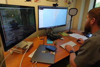
Rafael Abreau Paris reviews the recent weekly aftershock probabilities for the M8.8 Russian Kamchatka Peninsula quake.
Following the M8.8 Russian Kamchatka Peninsula Earthquake, the USGS has released new aftershock forecasts that detail the likelihood and magnitude of future earthquakes expected in the region.
Within the first week following the magnitude 8.8 event, scientists calculated:
2% chance of additional magnitude 8 or larger aftershocks
24% chance of additional magnitude 7 or larger aftershocks
96% chance of additional magnitude 6 or larger aftershocks
greater than 99% chance of more magnitude 5 or larger aftershocks
greater than 99% chance of more magnitude 4 or larger aftershocks
greater than 99% chance of more magnitude 3 or larger aftershocks
These forecasts prove vital for residents and responders who must remain vigilant and prepared for subsequent tremors that can continue for weeks, months, or even years after a major earthquake. Forecasts will be updated as more information becomes available.
Event Summary
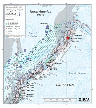
On July 29, 2025, at 7:25pm EDT (July 30, 2025, 11:25am local time), a magnitude 8.8 earthquake struck offshore the Kamchatka Peninsula, Russia, tying it for the sixth-largest earthquake ever recorded by modern seismic instruments. The massive earthquake triggered Pacific-wide tsunami watches and warnings.
This historic earthquake was not an isolated event. It followed a 10-day sequence that began with 50 magnitude 5.0 or larger earthquakes, including a magnitude 7.4 earthquake on July 20 and three magnitude 6.6 earthquakes. The sequence remains active as scientists monitor ongoing aftershocks, including M6.9 and M6.2 quakes.
To learn more about the seismotectonics of the Kuril-Kamchatka subduction zone, check out our new geonarrative.
Science in Action: USGS Response Tools
Within moments of detecting the massive earthquake, a comprehensive suite of monitoring and assessment tools were issued to evaluate its impact and guide emergency response efforts worldwide. These science-based tools, developed through years of research and international collaboration, provide critical information in the crucial hours and days following major seismic events.
Visualization of shaking and energy released from earthquake fault rupture.
Scientists at the U.S. Geological Survey’s (USGS) National Earthquake Information Center modeled the extent and timing of rupture, determining that the earthquake tore through an area spanning approximately 300 by 100 miles. The fault slipped up to 30 feet as the rupture took roughly 3.5 minutes to complete its course. Because the earthquake occurred at a shallow 12-mile depth on a subduction plate boundary, the earthquake caused the seafloor to move vertically, displacing water and generating a tsunami threat across the Pacific Basin. The earthquake also caused severe local shaking. Data from the Global Seismographic Network, operated by the USGS and National Science Foundation, was essential to rapidly and accurately estimating the size and extent of the earthquake's rupture in the remote Kamchatka region.
“Rapidly understanding the size, location, and mechanism of the earthquake is crucial for agencies, like the National Oceanic and Atmospheric Administration, to issue accurate tsunami warnings and for the USGS to estimate the earthquake's shaking-related impacts," said USGS seismologist William Yeck.
The earthquake's shallow depth and oceanic location made it particularly concerning for coastal communities across the Pacific Rim.
USGS seismologist Will Yeck reviews the estimated fault rupture for the magnitude 8.8 Kamchatka Peninsula, Russia, Earthquake (2025).
PAGER: Rapid Impact Assessment
Immediately following the earthquake, the USGS activated its PAGER system, which provides rapid assessments of likely impact via estimates of the number of fatalities and economic losses. For the Kamchatka Peninsula, Russia earthquake, PAGER issued a RED alert for economic losses and a YELLOW alert for fatalities, indicating losses would likely be severe and widespread.
"Timely data and resources that characterize event details and impacts are among the most effective ways to reduce risk and inform response and recovery efforts,” said Yeck.
The PAGER system processes information about earthquake size, location, and shaking intensity, combined with population density and building fragility data. This analysis provides aid agencies and government entities with time-critical impact assessments within minutes of an event.
The Global Seismographic Network (GSN) is a permanent digital network of state-of-the-art seismological and geophysical sensors that serves as a resource for monitoring, research, and education. GSN provides near-uniform, worldwide monitoring of the Earth, with approximately 150 modern seismic stations distributed globally.
The USGS collaborates with seismic networks and agencies worldwide to share data and expertise. This international cooperation enhances the accuracy of earthquake monitoring and hazard assessments, ensuring that critical information reaches communities across the globe.
Working across international boundaries allows scientists to provide comprehensive monitoring that would be impossible for any single agency to achieve. When earthquakes like the Kamchatka event occur, this collaborative network ensures that data flows quickly to the communities and countries that need it most.
Building Resilience Through Science
The devastating impact of large earthquakes in populated regions serves as a sobering reminder of the importance of preparedness and scientific monitoring. The USGS continues its mission to detect, locate, and report earthquake events while developing new tools and resources to help communities understand and prepare for seismic hazards.
As the Kamchatka sequence continues, scientists maintain their vigilant monitoring, providing ongoing updates and analysis. Each earthquake offers new data that improves understanding of seismic processes and enhances the tools used to protect communities worldwide.
The rapid response to the July 2025 M8.8 Russian earthquake demonstrates how science-based tools can transform devastating natural events into opportunities for learning, preparedness, and ultimately, better protection of communities through improved understanding of our dynamic planet.
10 Largest Earthquakes Ever Recorded (Updated 2025)
10 Largest Earthquakes Ever Recorded (Updated 2025)
#10. MAGNITUDE 8.6 (1950). Arunachal Pradesh, India - Referred to as the Assam-Tibet earthquake, this quake produced intense shaking, triggered sandblows, ground cracks, and large landslides across the region. All told, 780 people died.
10 Largest Earthquakes Ever Recorded (Updated 2025)
#10. MAGNITUDE 8.6 (1950). Arunachal Pradesh, India - Referred to as the Assam-Tibet earthquake, this quake produced intense shaking, triggered sandblows, ground cracks, and large landslides across the region. All told, 780 people died.
"Foreshock" and "aftershock" are relative terms. Foreshocks are earthquakes that precede larger earthquakes in the same location. An earthquake cannot be identified as a foreshock until after a larger earthquake in the same area occurs. Aftershocks are smaller earthquakes that occur in the same general area during the days to years following a larger event or "mainshock." They occur within 1-2...
"Foreshock" and "aftershock" are relative terms. Foreshocks are earthquakes that precede larger earthquakes in the same location. An earthquake cannot be identified as a foreshock until after a larger earthquake in the same area occurs. Aftershocks are smaller earthquakes that occur in the same general area during the days to years following a larger event or "mainshock." They occur within 1-2...
Sometimes, yes. A few large regional earthquakes (greater than magnitude 6) are considered to be related to a subsequent eruption or to some type of unrest at a nearby volcano. However, volcanoes can only be triggered into eruption by nearby tectonic earthquakes if they are already poised to erupt. This requires two conditions to be met: Enough "eruptible" magma within the volcanic system...
Sometimes, yes. A few large regional earthquakes (greater than magnitude 6) are considered to be related to a subsequent eruption or to some type of unrest at a nearby volcano. However, volcanoes can only be triggered into eruption by nearby tectonic earthquakes if they are already poised to erupt. This requires two conditions to be met: Enough "eruptible" magma within the volcanic system...
10 Largest Earthquakes Ever Recorded (Updated 2025)
10 Largest Earthquakes Ever Recorded (Updated 2025)
#10. MAGNITUDE 8.6 (1950). Arunachal Pradesh, India - Referred to as the Assam-Tibet earthquake, this quake produced intense shaking, triggered sandblows, ground cracks, and large landslides across the region. All told, 780 people died.
10 Largest Earthquakes Ever Recorded (Updated 2025)
#10. MAGNITUDE 8.6 (1950). Arunachal Pradesh, India - Referred to as the Assam-Tibet earthquake, this quake produced intense shaking, triggered sandblows, ground cracks, and large landslides across the region. All told, 780 people died.
"Foreshock" and "aftershock" are relative terms. Foreshocks are earthquakes that precede larger earthquakes in the same location. An earthquake cannot be identified as a foreshock until after a larger earthquake in the same area occurs. Aftershocks are smaller earthquakes that occur in the same general area during the days to years following a larger event or "mainshock." They occur within 1-2...
"Foreshock" and "aftershock" are relative terms. Foreshocks are earthquakes that precede larger earthquakes in the same location. An earthquake cannot be identified as a foreshock until after a larger earthquake in the same area occurs. Aftershocks are smaller earthquakes that occur in the same general area during the days to years following a larger event or "mainshock." They occur within 1-2...
Sometimes, yes. A few large regional earthquakes (greater than magnitude 6) are considered to be related to a subsequent eruption or to some type of unrest at a nearby volcano. However, volcanoes can only be triggered into eruption by nearby tectonic earthquakes if they are already poised to erupt. This requires two conditions to be met: Enough "eruptible" magma within the volcanic system...
Sometimes, yes. A few large regional earthquakes (greater than magnitude 6) are considered to be related to a subsequent eruption or to some type of unrest at a nearby volcano. However, volcanoes can only be triggered into eruption by nearby tectonic earthquakes if they are already poised to erupt. This requires two conditions to be met: Enough "eruptible" magma within the volcanic system...