

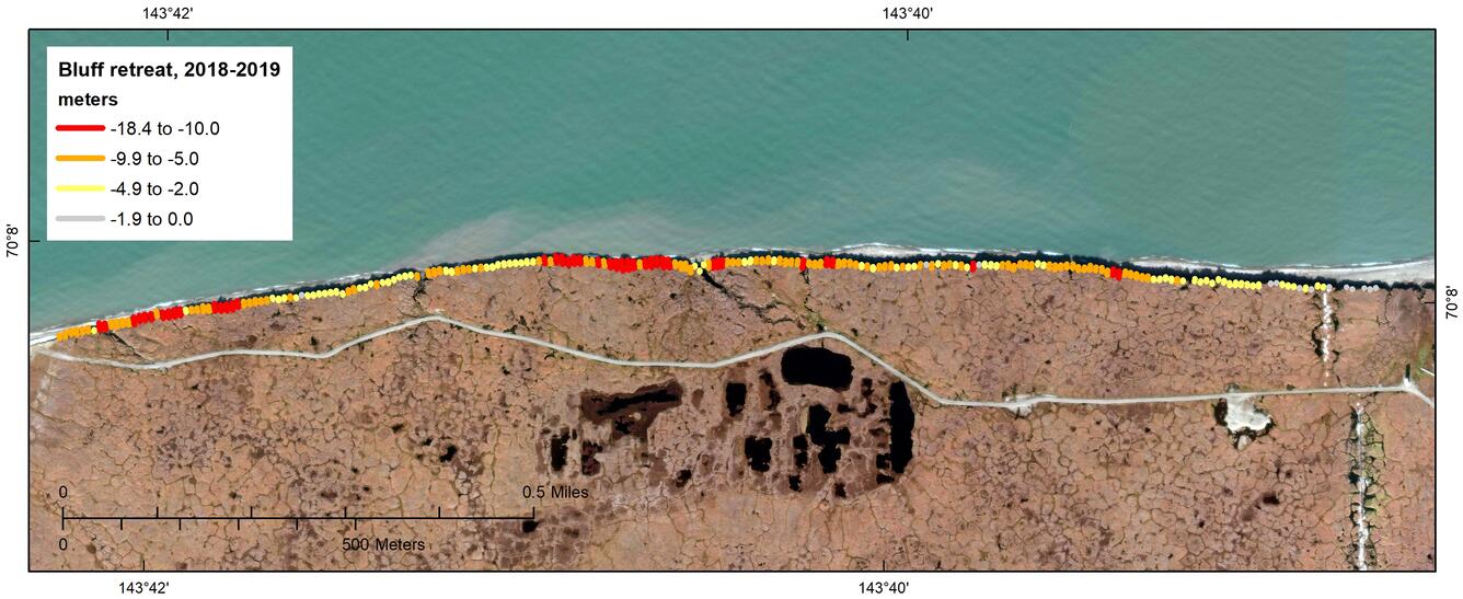
In the spring, winter sea ice thaws and moves offshore leaving the coast exposed to increased wave action and relatively warm water temperatures that, when in contact with the bluff, erodes the toe of the bluff.
The Challenges of Arctic Fieldwork
By Pacific Coastal and Marine Science Center
December 31, 2019
On a far-away island along Alaska’s North Slope coast, conducting fieldwork can be challenging.

Sources/Usage: Public Domain. View Media Details
This article is part of the October-December 2019 issue of the Sound Waves newsletter.
On a far-away island along Alaska’s North Slope coast, conducting fieldwork can be challenging. With temperatures on Barter Island reaching only into the high 30s (Fahrenheit), installing equipment and handling tools and instruments prove to be difficult tasks.
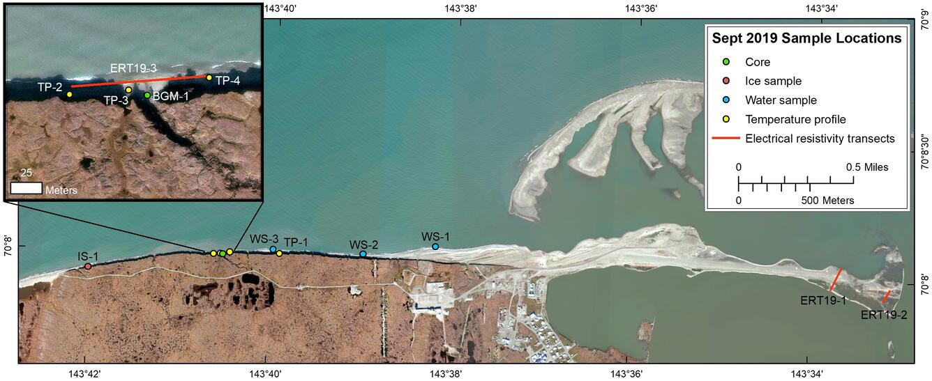
USGS scientists Ann Gibbs, Cordell Johnson, Josh Logan, and Dan Nowacki from the USGS Pacific Coastal and Marine Science Center visited Barter Island, Alaska between September 2 and 10, 2019 to collect a variety of field data. Visiting the area a few times per year and during different seasons, their work supports a decade-long research project measuring permafrost degradation, coastal erosion, and flooding hazards on and around Barter Island.
Sources/Usage: Public Domain. View Media Details
Examples of UAS photography

Sources/Usage: Public Domain. View Media Details

Sources/Usage: Public Domain. View Media Details

Sources/Usage: Public Domain. View Media Details

Sources/Usage: Public Domain. View Media Details

Sources/Usage: Public Domain. View Media Details

Sources/Usage: Public Domain. View Media Details
The scientists maneuver all-terrain vehicles, fly unmanned aerial systems (UAS), lay out ground control targets for aerial photography, set up global positioning system (GPS) base stations, drill holes and dig trenches in the frozen tundra to take samples and set instruments, collect electrical resistivity tomography profiles, and more, all in heavy, bulky outerwear to protect themselves from the extreme cold. High coastal erosion rates in the area cause cliff collapse, so time-lapse camera systems, set out to capture the seasonal effects of wave attack on permafrost cliffs, often tumble to the beach. The cameras may or may not be recoverable, but at least the imagery is successfully transmitted to USGS computers.

Sources/Usage: Public Domain. View Media Details

Sources/Usage: Public Domain. View Media Details

Sources/Usage: Public Domain. View Media Details
Perhaps the biggest challenge in conducting fieldwork at this remote region is the abundance of polar bears. Subsistence whaling activities by the indigenous Iñupiat people attract numerous polar bears to Barter Island every year. Of course, the bears’ presence requires constant vigilance while conducting fieldwork. But to make things even more complicated, the curious bears also seem to have discovered some strange toys on the tundra: USGS field equipment!

Sources/Usage: Public Domain. View Media Details

Sources/Usage: Public Domain. View Media Details
Polar bear play time
Some of the time-lapse camera systems, with their metal poles and attachments, served as scratching posts for the bears. When the poles have not tumbled down onto the beach due to coastal erosion, they are being bent and dislodged from their mounts when the bears rub against them. Other field equipment, like a GPS ground target—a small tarp laid on the ground for aerial photograph alignment—served as entertainment for groups of bears, who were observed tossing around the tarp like puppies with a towel.
Sources/Usage: Public Domain. View Media Details

Sources/Usage: Public Domain. View Media Details
While the bears did prevent the USGS scientists from completing all of their planned activities, it was a successful field season. Data collected included three electrical resistivity tomography (ERT) transects (ERT is a geophysical technique for imaging subsurface structures using electrical resistivity measurements by electrodes set down in boreholes), a 6-meter, 20-centimeter-in-diameter sediment core to ground-truth the ERT data, water and ice samples, bluff temperature profiles, and UAS-based photography and thermal imagery.
Ann Gibbs also visited the local high school and talked with the class about their research projects, the type of work the USGS is doing, and the data collected during the September visit.
Related Content
Climate impacts to Arctic coasts
The Arctic region is warming faster than anywhere else in the nation. Understanding the rates and causes of coastal change in Alaska is needed to identify and mitigate hazards that might affect people and animals that call Alaska home.

Animation depicting seasonal cycles on Alaska's Arctic bluffs
In the spring, winter sea ice thaws and moves offshore leaving the coast exposed to increased wave action and relatively warm water temperatures that, when in contact with the bluff, erodes the toe of the bluff.

Time-lapse video of bluff erosion on Barter Island, Alaska
Recorded June 1, 2019 - August 18, 2019: Video shows a series of photos taken every hour during daylight hours in the summer of 2019. The camera looks westward along the coastal bluffs of Barter Island, located on Alaska’s North Slope.
Recorded June 1, 2019 - August 18, 2019: Video shows a series of photos taken every hour during daylight hours in the summer of 2019. The camera looks westward along the coastal bluffs of Barter Island, located on Alaska’s North Slope.
Related Content
- Science
Climate impacts to Arctic coasts
The Arctic region is warming faster than anywhere else in the nation. Understanding the rates and causes of coastal change in Alaska is needed to identify and mitigate hazards that might affect people and animals that call Alaska home. - Multimedia
Animation depicting seasonal cycles on Alaska's Arctic bluffs
In the spring, winter sea ice thaws and moves offshore leaving the coast exposed to increased wave action and relatively warm water temperatures that, when in contact with the bluff, erodes the toe of the bluff.
In the spring, winter sea ice thaws and moves offshore leaving the coast exposed to increased wave action and relatively warm water temperatures that, when in contact with the bluff, erodes the toe of the bluff.
Time-lapse video of bluff erosion on Barter Island, AlaskaRecorded June 1, 2019 - August 18, 2019: Video shows a series of photos taken every hour during daylight hours in the summer of 2019. The camera looks westward along the coastal bluffs of Barter Island, located on Alaska’s North Slope.
Recorded June 1, 2019 - August 18, 2019: Video shows a series of photos taken every hour during daylight hours in the summer of 2019. The camera looks westward along the coastal bluffs of Barter Island, located on Alaska’s North Slope.
- News
Get Our News
These items are in the RSS feed format (Really Simple Syndication) based on categories such as topics, locations, and more. You can install and RSS reader browser extension, software, or use a third-party service to receive immediate news updates depending on the feed that you have added. If you click the feed links below, they may look strange because they are simply XML code. An RSS reader can easily read this code and push out a notification to you when something new is posted to our site.