
Landsat 8
Synthetic Landsat
LANDFIRE-informed Land Cover
On a cool March morning in 2019, LANDFIRE program leaders were sitting in a conference room at the USGS Earth Resources Observation and Science (EROS) Center, listening to a presentation from a team led by EROS scientist Jesslyn Brown.
The meeting wasn’t billed as a monumental occasion. It was more akin to a lunch-and-learn session for two Landsat-based mapping teams: Brown is the science lead for the Land Change Monitoring, Assessment, and Projection (LCMAP) initiative, which is producing annual land cover and change data for the conterminous U.S. (CONUS); LANDFIRE’s team produces more detailed but less timely geospatial maps of vegetation type, height, and the like.
The meeting would, in fact, prove informative for LANDFIRE. Its production team was in the throes of a full-scale update of its circa 2001 base map– a massive undertaking that intends to improve its product suite across the United States.
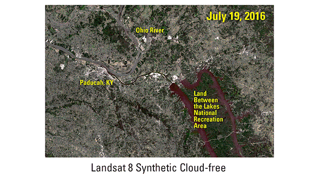
What Brown’s team offered, without explicitly saying so, was an innovative way to address a mapping problem. Woven into slides on goals, methods, and progress was an enticing byproduct of LCMAP’s change detection algorithm: A date-stamped Landsat image for the East Coast, completely free of clouds and spectral artifacts.

The twist? It wasn’t actually a Landsat image at all.
What the LANDFIRE team saw was a spectral prediction of sorts, showing not how the land actually appeared that day, but rather how it would have, given the area’s observed history. LCMAP’s algorithmic analysis and harmonic modeling of more than 30 years of Landsat observations, she explained, made it possible to produce “synthetic” observations for any location in the conterminous United States, on any given day of any given year, from 1984 through the present.
What is a Synthetic Landsat image?
It was a light bulb moment for EROS contractor Brian Tolk and his LANDFIRE co-workers. They’d just begun slogging through scenes along the east coast in search of clear images that fit LANDFIRE’s target dates, and it hadn’t been easy.
“They flashed that image on the screen, and I was sitting there thinking, ‘man, that’s pretty nice,” Tolk said. “It was cloud-free, and because we need to build multi-scene mosaics, using that same date would eliminate the major issues routinely giving us fits.”
The March meeting sparked an inter-project collaboration that would not only speed up the LANDFIRE Remap process for the Eastern U.S., but improve that process more dramatically than the remap project had anticipated. In the end, LANDFIRE produced seamless image mosaics for three of its 13 “vegetation production units” – roughly a fifth of the United States – using entirely synthetic imagery.
Mapping By Satellite Through Clouds and Seasons
To understand why synthetic imagery was such a game-changer, it’s helpful to explore what satellite-based land cover mapping entails.
Satellite images typically reflect conditions on the Earth’s surface at a given point in time.
Mapping land cover with Landsat imagery, however, is typically not a matter of replicating how the Earth appeared on a specific day. It’s more akin to painting from satellite memory.
Imagine passing a park each day on your way to work, a park with patches of wildflowers and trees, long stretches of grassy fields, and perhaps a handful of community garden plots.
Those features aren’t static. White winter snow gives way to the browned Earth of early spring, from which shoots of green emerge, grow and brighten. Flowers bloom and vegetables swell through the summer. Walnuts, maple seeds, and leaves of orange and yellow drop from the trees in autumn.
Some days are cloudy, some are sunny. Sometimes the park is blanketed in snow or wet with rain. Yet surely you hold a clear image in your mind’s eye of how the park appears during each season.
Land cover maps essentially aim for a similar result: A geospatial data product that represents the clearest, most accurate picture of what’s on the Earth’s surface in a given year or season. Land cover maps are not satellite observations, but rather a melded view of the land surface built from many individual observations.
There are two primary challenges, though. First, Landsat imagery comes not daily, but every 16 days (every eight days when two satellites are operating). Second, clouds can block the view of the Earth beneath them. In especially cloudy regions of the country, those dual difficulties can be especially troublesome when the goal is a map meant to represent a particular point in time.
Former EROS Chief Scientist Tom Loveland helped guide land cover mapping for decades and championed the LCMAP approach prior to his 2018 retirement. Cloud troubles and inconsistencies from one available date to the next have dogged Landsat-based efforts from the start, he said.
“The fact is, there are just so many inconsistencies (from observation to observation),” Loveland said. “That’s why we have errors in our results. One of the things we moved to in LCMAP was to use as many observations as we have. The more data points you have, the more observations you can use to determine what’s there at a given point in time, and the better chance you have to separate signal from noise.”

Moving Beyond ‘Best Pixel’
LANDFIRE, like any land cover mapping program, has spent years fine-tuning its approach to handling those issues. Research teams typically look for scenes collected within a few days of specific dates (e.g. May 15 for spring). When clouds block the satellite’s view on the target date, they’re forced to look to other days for observations, sometimes even outside the target year.
The LANDFIRE team has worked since 2011 to fine-tune a semi-automated “best pixel” approach to mask clouds and fill in gaps. It involves pre-selecting scenes manually, scouring the Landsat archive for the best gap filing options using high-performance computing resources, and checking troublesome pixels for accuracy against the program’s network of on-the-ground reference data.
That approach drove the lion’s share of the remap work, and it was a vast improvement over the past efforts. In truth, it’s an approach that wasn’t technically or economically possible when LANDFIRE launched.
“When we were first doing what we now refer to as LANDFIRE National Production (in 2001), Landsat imagery was not free,” said Birgit Peterson, the USGS EROS Fire Science lead. “This limited the approaches that could be used to alleviate issues with the imagery and introduced artifacts in the final products, impacting the quality of the initial base maps.”
That’s why the remap work is so important: the better the base map, the better the products derived from it. The availability of free and open Landsat data since 2008 and the best pixel approach that undergirds it already promised big improvements.
The synthetic data has become a powerful tool for overcoming the issues that remain, even in the free-and-open data era. Along the cloud-prone eastern seaboard and Gulf Coast, Tolk said, synthetic data was more likely to align with ground conditions than “best pixel” images.
“The way those scenes came together was dramatically better than anything we’d used before,” Tolk said. “It was cleaner and easier to use.”
Initial Collaboration ‘Only Scratches the Surface’

Brown is pleased with how helpful the LCMAP synthetic imagery has been, a situation she calls “a happy accident.” The LCMAP team knew there was value in the synthetic imagery, but her team is focused on the production of its own land cover and land surface change products. The synthetic imagery is not part of the initial LCMAP product suite.
“We sort of understood within the project that it’s a capability that’s probably useful for a lot of things, but it hasn’t been our primary focus,” Brown said. “I think the value of these images is recognized, but we haven’t gone the distance with them. We’re only scratching the surface.”
She’s also pleased to see how collaboration is helping to produce better products across separate projects. Differing land cover products have different customers and purposes, she said, but collaboration can improve products across the board.
“We do have a goal in science to improve efficiencies between (these projects), and this is sign of us working in that direction,” Brown said.
Loveland was also excited to learn that LANDFIRE had moved to incorporate the synthetic imagery into its products. The move highlights not only the value in collaboration within EROS, but the potential worldwide appeal of the LCMAP approach. The Canadian Forest Service, for example, uses a “best pixel” approach for its own national forest mapping products, and could conceivably save time and effort in the manner LANDFIRE has through the embrace of synthetic data.
“As it turns out, it really does have scientific value,” he said. “That’s the part that really excites me, if LANDFIRE is going to go that way. That’s potentially a really innovative step.”
LANDFIRE’S remap for the conterminous United States (CONUS) has rolled out in stages. The final sections of CONUS, which include the East Coast, will begin its release in spring of 2020. Remap work for Alaska and Hawaii is already ramping up.
For more information on LANDFIRE Remap, visit this link.
Related Content

LCMAP Offers Insight on Dynamic Wetlands

LANDFIRE-Landscape Fire and Resource Management Planning Tools
Related Content
LCMAP Offers Insight on Dynamic Wetlands
LANDFIRE-Landscape Fire and Resource Management Planning Tools
Get Our News
These items are in the RSS feed format (Really Simple Syndication) based on categories such as topics, locations, and more. You can install and RSS reader browser extension, software, or use a third-party service to receive immediate news updates depending on the feed that you have added. If you click the feed links below, they may look strange because they are simply XML code. An RSS reader can easily read this code and push out a notification to you when something new is posted to our site.