
June is National Ocean Month!
Discover the breadth of USGS ocean and coastal research.
The White House has proclaimed June 2021 as National Ocean Month.
"By protecting our ocean and coastal ecosystems and resources, we are also protecting the worldwide economies and people that depend on them. To address these challenges, we are building on our Nation’s long legacy of ocean exploration and research to gain new insights into ocean ecosystems and biodiversity and ways the ocean can sequester and store carbon."
- A Proclamation on National Ocean Month
The ocean provides vast benefits to society, from resources, food, and jobs, to half of the oxygen in the air that we breathe. USGS conducts research in diverse environments to better understand our coastal and ocean resources. Here, we explore how science helps society better understand the vast influences the ocean has on global resources as well as how we respond to specific challenges from the Nation’s coasts to the deep sea.
Our Ocean, Natural Hazards, and Climate Change

The global ocean occupies the majority of the Earth’s surface and plays a significant role in large processes such as plate tectonics, climate and weather patterns. USGS studies tectonic structures and related seismic activity and movement from identifying faults, and studies the processes involved in underwater earthquakes and tsunamis so our Nation can be better prepared for these oceanic hazards.
Underwater earthquakes can generate tsunamis that pose risk to coastal communities. USGS scientists study the recent history of underwater earthquakes and tsunamis and evaluate the future potential and probable impacts of such events on a regional basis. The Marine Geohazards Sources and Probabilities project works to quantify marine hazards such as earthquakes, landslides, tsunamis, and volcanoes in marine and coastal environments by using geological and geophysical data and models; develop the technologies and methodologies needed to do so; understand the underlying processes of these marine hazards to inform hazard estimations; and develop reliable estimates of the hazards to be used by engineers and policymakers.

The dynamic coastal landscape of California is a setting where science in tectonics, landslides, coastal change, ecosystems, wildfire, and hydrology come together. USGS brings expertise from these various disciplines to improve understanding as we fulfill the mission for reducing risk from natural hazards for the Nation. CMHRP uses remote sensing technologies to monitor coastal landslides and collect elevation change data that can be used by partners such as the Department of Transportation to plan for, adapt to, and mitigate these hazardous events.
USGS also studies how our ocean environment is responding as the planet’s climate changes. Climate change and sea-level rise are already impacting coastal communities in many locations worldwide. USGS assesses present and future coastal vulnerability to provide actionable hazards information and decision support for management of our Nation’s coasts. USGS uses multidisciplinary research to develop products and tools to explore the future likelihood of sea-level rise impacts, including the Sea-Level Rise Data Viewer that provides the ability for users to explore sea-level rise scenarios at various locations throughout the U.S. The Sea-Level Rise Scenarios geonarrative provides context for understanding the scenarios and how they were generated. These data and products can be applied to inform adaptation strategies, evaluate tradeoffs, and examine mitigation options.

USGS scientists also investigate underwater impacts of climate change such as ocean acidification, which is the decline of ocean pH driven by rising atmospheric carbon dioxide and absorption into the ocean. Acidification can cause harmful effects to marine systems by affecting calcification rates or dissolving carbonate materials such as sediment and the shells and skeletons of marine organisms like corals and commercially-important shellfish. Careful seawater chemistry monitoring and dedicated carbonate research help inform management and mitigation strategies for the impacts of increasing acidity in our oceans.
Storms
Our ocean and Earth’s atmospheric conditions are intricately connected – both influencing each other in numerous ways. One of the ways the ocean affects our weather is by supporting the formation of tropical storms and hurricanes. These events can lead to considerable changes to coastal and marine environments and pose risks to people and infrastructure.
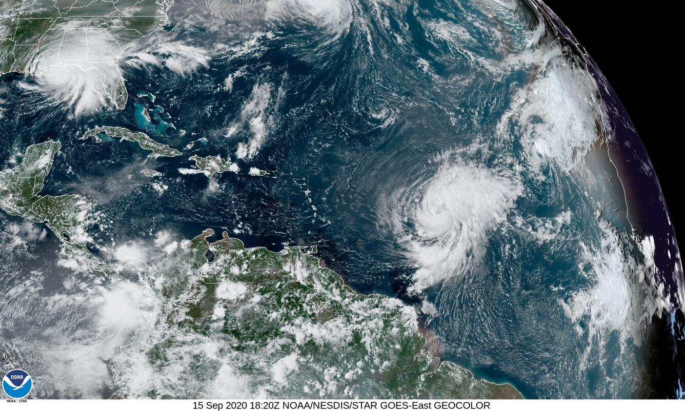

The USGS studies, models, and forecasts the effects of extreme coastal storms, sea-level rise, hurricanes, and nor’easters along our coasts to help the Nation better prepare for these hazards. Our Coastal Change Hazards focus integrates stakeholder input into research priorities and when designing technical capabilities and applications such as the Total Water Level and Coastal Change Forecast Viewer - a tool that allows users to visualize forecasted water levels along 3,000 miles of coastline. Our products are developed in a user-centric way so that our data and tools are accessible to those who need them.
Hurricane Sandy, one of the most destructive hurricanes in U.S. history, significantly affected the mid Atlantic coast in 2012. In New Jersey, where Sandy made landfall, much of the coast consists of barrier islands - narrow stretches of sand deposited parallel to the mainland coast – that were deeply eroded, overwashed, and breached by the storm. USGS scientists are studying the evolution and behavior of the New Jersey barrier island system so they can provide managers with the data and tools necessary to reduce vulnerability and ensure that human activities and development do not interfere with the natural resiliency of the barrier island system and thus, the numerous benefits the islands provide.

Coastal Environments
Coasts are the borders between terrestrial habitats/people and the ocean environment. These are unique ecosystems that support diverse wildlife and protect coastal communities and infrastructure from coastal hazards such as storm waves and sea-level rise. USGS studies movement of sediments, the foundation of many coastal environments; how various riverine and estuarine systems interact with the coast; and how erosional processes affect permafrost bluffs. We also use next-generation technology, including remote-sensing technologies—such as aerial photography, time-series video camera image collection, satellite imagery, structure-from-motion (SfM) photogrammetry, and lidar (laser-based surveying) to monitor coastal change. For example, within a few days after Hurricane Isaias, the USGS Remote Sensing Coastal Change project rapidly processed Emergency Response Imagery collected by NOAA’s National Geodetic Survey. The results provided the National Park Service with critical information before field-based assessment teams were deployed on the ground. Much of our data and understanding are incorporated into models that are used to forecast future change over short- and long-term time scales, or used to develop products and tools that allow stakeholders to better understand their changing coastal environments and shoreline positions.


USGS also conducts research in the Great Lakes. As part of the Geologic Mapping: Links to Coastal Vulnerability and Hazards Project, USGS scientists conducted high-resolution geophysical mapping of the floor of Lake Superior to determine the distribution and thickness of historical mine tailings. Movement of that sediment has caused progradation of the beach and damming of stream outlets downdrift of the pile. In the offshore, USGS mapping will characterize the extent of sedimentation on the sensitive hard-bottom habitats, and help quantify the spreading environmental effects from copper and other metals that threaten critical fish breeding grounds.
Explore more of our Coastal Change Hazards work and our Coastal Science Stories.
Wetlands and Estuaries
Wetlands and estuaries are the gateway to our oceans, acting as a transition from terrestrial and aquatic environments into the saline waters of our planet’s largest ecosystem. USGS studies estuarine processes, hazards, and ecosystems through observations and numerical modeling to better understand the past, present, and future states of estuaries. Our scientists also collect geologic data in marsh environments to study how and where short- and long-term coastal processes interact, how they influence coastal accretion or erosion, and how they influence marsh resiliency to storms, sea-level change, and human alterations. USGS develops metrices such as the Unvegetated to Vegetated Ratio (UVVR) to assess wetland vulnerability to change and to inform partners working to restore coastal wetland habitats.

USGS national- and local-scale mapping of coastal elevation, infrastructure, wetland conditions, carbon sequestration, and methane emissions helps partners identify opportunities for restoration that will improve habitat while reducing greenhouse gas emissions into the atmosphere, helping federal agencies such as the U.S. Fish and Wildlife Service and the National Park Service with management decisions, and aiding state and local governments in meeting emission reduction targets. Diked wetlands (wetlands with an embankment controlling the wetland’s water level) and tidally restricted wetlands (wetlands that have been separated from the ocean by infrastructure) are currently being mapped on a national scale, including the roads, railroads, and other infrastructure that interact with them. USGS scientists are bringing together expertise in multiple coastal science disciplines to support restoring the National Park Service’s Herring River at the Cape Cod National Seashore—a $50 million restoration of 1,000 acres of diked wetland and estuary that is now both drained and impounded in different portions. The National Park Service, USGS, and collaborators within the Bringing Wetlands to Market team are working on science for understanding carbon cycling and informing how wetland restoration is accounted for in the carbon market and greenhouse gas offsets at federal or state levels.
Continental Shelf
The continental shelf extends from shore out to 200 nm and is home to diverse marine life and ecosystems such as coral and rocky reefs, kelp forests, and more. USGS conducts research on the habitats and resources in, and services provided by these various continental shelf ecosystems.

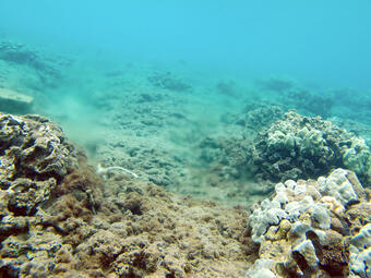
More than 8,500 square miles (22,000 square kilometers) of coral reef habitat is found in U.S. waters. Most of these coral reefs are relatively healthy, but some areas have been degrading likely in part related to human activities. Coral reefs are not just important for supporting marine biodiversity, but USGS research shows that they also provide $1.8 billion in coastal protection from the impacts of storms and waves. USGS research can inform reef restoration through projects like the Role of Reefs in Coastal Protection. For instance, evaluations of how coral restoration can reduce coastal flooding indicate that more physically robust species of coral need to be outplanted to shallower, more energetic locations in order to increase the coastal hazard risk reduction potential of reef restoration, rather than the more fragile, faster-growing species that are primarily being grown in coral nurseries. (Explore this geonarrative to learn more: The Role of U.S. Coral Reefs in Coastal Protection.)
The Coral Reef Ecosystem Studies (CREST) project investigates the variables that affect coral growth rates at coral reefs throughout Florida and the U.S. Caribbean in modern times, and how growth rates have changed over the last 10,000 years. Understanding coral growth and the factors that influence it will help inform reef restoration efforts and help scientists predict the future of reefs along the U.S. continental shelf. The Microbial Ecology group also studies the microbiomes of corals, including which microbes are beneficial or detrimental to corals. They work to identify the causes of coral diseases, such as the Stony Coral Tissue Loss Disease (SCTLD) that has devastated reefs in the Atlantic and Caribbean.

As part of the Climate Change and Land-use Histories project, researchers at USGS are developing new and unique oceanographic and environmental archives from coral skeleton records to better understand the compounding effects of land-use and environmental change on coral reef health across U.S. Pacific islands. We aim to introduce coral-derived time-series information into monitoring and future management decisions to reduce and prevent land-based sources of pollution, including forecasting future impacts and response to load reductions expected from implementation of specific management tactics.
The services provided by coral reefs depend on whether or not reefs grow fast enough to keep up with rising sea level. However, many coral reef ecosystems are degrading due to human and natural impacts. The USGS quantifies coral reef seafloor accretion (growth) or erosion by collecting high-resolution orthoimagery to understand the processes that influence reef accretion or erosion, and quantifying how seafloor elevation and stability change over time. This information is fundamental to answer questions of reef health, resiliency, and vulnerability of coastal communities to coastal and socioeconomic hazards, as well as to help partners make informed decisions on where to focus reef restoration efforts.
The USGS Law of the Sea project helps identify the submerged extent of the U.S. land territory beyond 200 nautical miles, referred to as the Extended Continental Shelf (ECS). USGS acquires and interprets geologic data to help better protect, manage, and use the seabed resources contained within the ECS. On smaller scales, USGS creates regional seafloor maps in places like Massachusetts, Florida and California that can help partners with resource management and restoration decisions.

Deep Sea
The ocean covers 71% of our Earth’s surface, yet we know very little about this vast underwater world. USGS dives deep into our oceans to investigate oceanic hazards, biological and energy resources, minerals, and deep water habitats. As part of the EXPRESS project (Expanding Pacific Research and Exploration of Submerged Systems), USGS investigates deep-sea mineral resources of industry interest and maps high priority benthic habitats such as deep-sea coral reefs to inform ocean energy and resource decisions to prevent impacts to sensitive habitats. (Learn more in this geonarrative: Expanding Pacific Exploration and Research.) The Diversity, Systematics and Connectivity of Vulnerable Reef Ecosystems (DISCOVRE) Project works to characterize the genetic makeup and microbial communities of deep water coral reefs to determine baselines prior to potential ecosystem impacts (e.g., oil spill, environmental change). These baselines will allow scientists to investigate the magnitude and effects of future change in these unique habitats.

USGS also conducts mapping of unexplored areas of the United States in support of the National strategy for mapping the Exclusive Economic Zone (EEZ). These efforts, such as our National Seafloor Mapping Project, the National Archive of Marine Seismic Surveys, the geologic mapping project in Massachusetts, the Massachusetts Integrated Coastal Studies project, and the Delmarva Geologic Framework and Evolution project help us better understand the geologic framework of our Nation’s coastal and marine areas. We provide high-resolution geologic maps to serve the needs of research, management, and the public. This type of information can be used to identify and evaluate potential hazards, resource vulnerability or availability of offshore resources such as sand for use in beach restoration and renourishment projects.

Energy and geohazards research within the USGS CMHRP is focused on three themes: gas hydrates (naturally-occurring ice-like deposits made of water and gas—typically methane), underwater earthquakes and tsunami hazards, and the sea floor beyond 200 nautical miles from shore, known as the extended continental shelf. The USGS works closely with other Federal agencies on implementing national gas hydrate research priorities and has been a leader in gas hydrates research for more than three decades. The USGS Gas Hydrates Project focuses on gas hydrates in the natural environment and seeks to advance understanding of the potential of gas hydrates as an energy resource; their role in, and susceptibility to climate change; and how they affect the stability of submarine slopes. USGS has collected over 2,000 km of multichannel seismic (MCS) data as part of the Mid-Atlantic Resource Imaging Experiment (MATRIX) to acquire data on methane seeps, which can affect methane inputs into the atmosphere, ocean acidification, the distribution of chemosynthetic communities and energy resources across the U.S. EEZ.
The USGS Extended Continental Shelf (ECS) Project supports the U.S. Department of State in delineating the outer limits of the U.S. ECS—the region beyond 200 nautical miles where coastal States (i.e., nations) can employ their sovereign rights to explore, manage, or conserve nonliving and sedentary living resources. The past two decades of data collection for this project are being synthesized into documentation of proposed U.S. ECS outer limits. There are seven core regions for which full documentation is underway, including the Arctic, Atlantic, Bering Sea, Gulf of Mexico-East, Marianas, Pacific/Mendocino, and Gulf of Mexico-West.

The USGS Coastal and Marine Hazards and Resources Program is dedicated to conducting robust scientific investigations about our Nation’s coastal and marine environments, and developing products and tools to help stakeholders better understand the resources and hazards that lie therein.
Stay up to date on our work:
- Visit the CMHRP website
- Subscribe to the Sound Waves Newsletter
- Explore our Strategic Plan
- Follow us on Facebook and Twitter
Get Our News
These items are in the RSS feed format (Really Simple Syndication) based on categories such as topics, locations, and more. You can install and RSS reader browser extension, software, or use a third-party service to receive immediate news updates depending on the feed that you have added. If you click the feed links below, they may look strange because they are simply XML code. An RSS reader can easily read this code and push out a notification to you when something new is posted to our site.