An official website of the United States government
Here's how you know
Official websites use .gov
A .gov website belongs to an official government organization in the United States.
Secure .gov websites use HTTPS
A lock () or https:// means you’ve safely connected to the .gov website. Share sensitive information only on official, secure websites.
This video was filmed on May 21, 2018, with a UAV (unmanned aerial vehicle). Limited UAV flights above the hazardous Kīlauea summit area, which is currently too dangerous for geologists to enter for ground observations, are conducted with permission from the National Park Service. The overflights collect visual information on what is happening at this rapidly changing vent. The information is used to quantify change and informs our assessment of hazards, which is shared with the National Park Service and emergency managers.At Kīlauea Volcano's summit, a nearly continuous plume of gas and steam billows out of the Overlook vent and drifts with the wind. Explosions are occurring about two times a day, producing ash that rises to a height of between 8,000 to 10,000 feet above sea level. Small ash emissions occur more frequently. The larger explosions produce ash that is blown downwind, and trace amounts have fallen in nearby communities.
Lower East Rift Zone UAS flights assist with remote data collection, lava flow mapping, and hazard assessment
This footage is from an Unmanned Aircraft System (UAS) hovering near fissure 22 during the overnight hours of May 22, 2018, and looking down on the fountaining fissure complex. The view rotates upward (to the south) to track channelized lava as it flows toward the Pacific Ocean, about 3 mi (5 km) away. The ocean entry is in the distance, recognizable by a small plume. The USGS National Unmanned Aircraft Systems Project Office is assisting with remote data collection and mapping of lava flows and hazards. UAS flights into hazardous areas allow USGS scientists to safely view, document, and better understand what's happening with Kīlauea's rapidly changing eruption and to provide information to Hawai‘i County Civil Defense and emergency officials. Video courtesy of the U.S. Department of the Interior Office of Aviation Services.
During HVO's overflight this morning, the fissure 22 fountain was not as high as several days ago, but was still erupting significant lava. USGS photo by M. Patrick.
Fissure 6 fountain, as of around 9:30 a.m. HST today. USGS photo by M. Patrick.
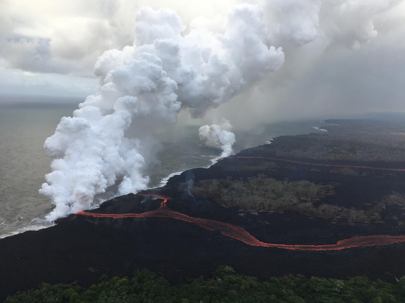
During today's overflight of the ongoing lower East Rift Zone eruption, HVO geologists noted that fissures 6, 13 and 22 were still erupting, with two channelized flows reaching the ocean. The eastern lava channel splits just before reaching the ocean, so it has two entry points, creating a total of three ocean entries on the flow field. USGS photo by M. Patrick.
Poor weather at the summit of Kīlauea has obscured views of Halema‘uma‘u for much of today, but a brief break in the weather around noon allowed HVO's webcam to capture this image of an ash plume rising from the crater at 12:17 p.m. HST. Even though weather has obscured visual observations of the ongoing summit explosions, HVO scientists are able to track them using signals from monitoring instruments, such as seismometers.
On Wednesday, May 23, the Hilo Civil Air Patrol conducted flights over the lower East Rift Zone eruption to assist USGS and Hawai‘i County Civil Defense Agency as they respond to the Kīlauea eruption. This image shows the scale of the lava channels feeding the ocean entries. Note that lava is overflowing the channels and is on top of slightly older, black lava flows. The visible haze is sulfur dioxide gas that's being emitted from the fissures.
On May 23, 2018, the Hilo Civil Air Patrol captured this evening photograph of the coastline where lava flows are entering the sea. There are currently three primary ocean entry points, which have evolved over the course of the eruption.
Get Our News
These items are in the RSS feed format (Really Simple Syndication) based on categories such as topics, locations, and more. You can install and RSS reader browser extension, software, or use a third-party service to receive immediate news updates depending on the feed that you have added. If you click the feed links below, they may look strange because they are simply XML code. An RSS reader can easily read this code and push out a notification to you when something new is posted to our site.