An official website of the United States government
Here's how you know
Official websites use .gov
A .gov website belongs to an official government organization in the United States.
Secure .gov websites use HTTPS
A lock () or https:// means you’ve safely connected to the .gov website. Share sensitive information only on official, secure websites.
No significant changes were observed at Kīlauea's summit today, during a routine overflight by Hawaiian Volcano Observatory geologists. Nice weather allowed for clear views of Kīlauea Caldera and this photo, looking west, shows the collapse area that formed during 2018, as well as the summit of Mauna Loa in the background. Lava flows that erupted in 1971 and 1974 (darker colored relative to other lava flows on Kīlauea Caldera floor) border the foreground in this image.
This image, looking northwest from the summit of Kīlauea, shows the growing crater lake within Halema‘uma‘u, with Mauna Kea summit in the background. Kīlauea's summit lake was rusty-brown in color today.
Steep walls, collapsed blocks, and rubble border Halema‘uma‘u Crater and Kīlauea's growing summit crater lake. In this photo, looking northwest, the summits of both Kīlauea (foreground) and Mauna Loa (background) are visible. USGS photos by K. Mulliken
During today's overflight of Kīlauea summit, both thermal and visual cameras were used to characterize activity. Comparing thermal (left) to visual (right) images of nearly the same view, you can see that the growing crater lake at Kīlauea's summit remains hot. Steam emanates from the lake surface in the visual image on the right, and the yellow and red colors in the thermal image indicate that the lake has a hotter surface temperature relative to the rocks and rubble around it. The lake isn't the only hot feature within Halema‘uma‘u, however, fumaroles on the crater wall, which stand out as white areas indicating alteration in the visual image, also stand out as bright white spots in the thermal image. USGS photo by K. Mulliken.
Portions of Crater Rim Drive are visible in three locations within this photo, which is angled looking north. Prior to 2018, Crater Rim Drive used to cross the southwest portion of Kīlauea Caldera. The collapse events of 2018 made the road impassable, as parts became severely damaged due to earthquakes, or completely collapsed. In the bottom half of this photo, fragments of the road are visible in the left center, the center of the image just below the lake, and the bottom right corner. USGS photo by K. Mulliken.
Keanakāko‘i Crater is featured prominently in the foreground of this photo, looking southeast during an overflight of Kīlauea's summit today. In 1974, fissures erupted in the vicinity of Keanakāko‘i Crater, partially filling it and feeding lava flows that traveled south. You can read more about the 1974 Kīlauea eruption in this "Volcano Watch" article. USGS photo by K. Mulliken.
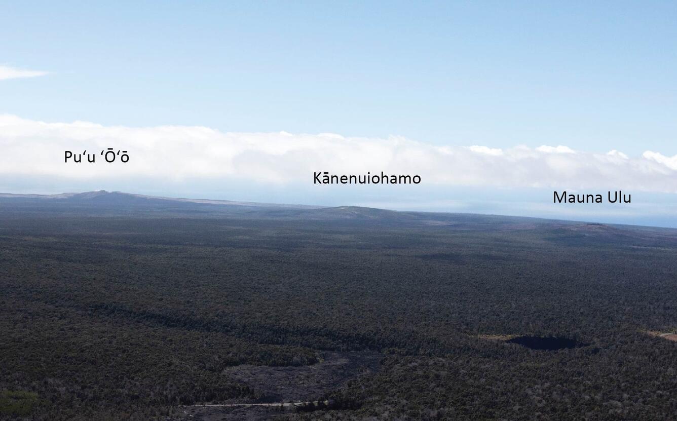
This view of Kīlauea's East Rift Zone was captured from the summit during today's overflight. Kīlauea's East Rift Zone has been the location of numerous eruptions over the past decades, some brief (days) and some longer-lived (years). In this photo, three prominent lava shields—which form during longer-lived eruptions—are visible: Mauna Ulu, Kānenuiohamo, and Pu‘u ‘Ō‘ō. Mauna Ulu was active from 1969–1974; Kānenuiohamo formed at least several hundred years ago; Pu‘u ‘Ō‘ō was active from 1983–2018.
Get Our News
These items are in the RSS feed format (Really Simple Syndication) based on categories such as topics, locations, and more. You can install and RSS reader browser extension, software, or use a third-party service to receive immediate news updates depending on the feed that you have added. If you click the feed links below, they may look strange because they are simply XML code. An RSS reader can easily read this code and push out a notification to you when something new is posted to our site.