U.S. flag

An official website of the United States government

October 16, 2020

Great Hawaii ShakeOut


During yesterday's Great Hawai‘i ShakeOut earthquake drill at 10:15 a.m., HVO staff practiced "Drop, Cover, and Hold on."
During yesterday's Great Hawai‘i ShakeOut earthquake drill at 10:15 a.m., HVO staff practiced "Drop, Cover, and Hold on." During an earthquake, you should DROP where you are, onto your hands and knees. COVER your head and neck with one arm and hand. If a sturdy table or desk is nearby, crawl underneath it for shelter. If no shelter is nearby, crawl next to an interior wall (away from windows). HOLD ON until shaking stops. For more information about preparing for earthquakes, visit https://www.shakeout.org/dropcoverholdon/. USGS photos by HVO staff.

 Photos of Kīlauea's summit

A wide-angle view of the western wall of Kīlauea caldera in Hawai‘i Volcanoes National Park
A wide-angle view of the western wall of Kīlauea caldera in Hawai‘i Volcanoes National Park as viewed from the foot of Byron Ledge trail (east wall of the caldera). The profile of Mauna Loa is visible in the background. The former site of HVO is perched on Uēkahuna Bluff, left of center in the image. This photo was taken in the early morning light, at 7:10 a.m. on October 9, 2020. USGS photo by Don Swanson.


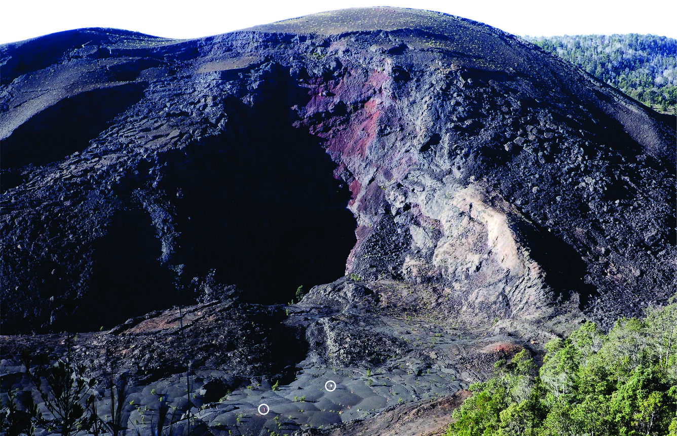
Pu‘u Pua‘i, a tephra cone formed during the 1959 eruption in Kīlauea Iki in Hawai‘i Volcanoes National Park.
Pu‘u Pua‘i, a tephra cone formed during the 1959 eruption in Kīlauea Iki in Hawai‘i Volcanoes National Park. View is from the north rim of Kīlauea Iki. In the upper right is part of south sulfur bank in Kīlauea caldera. This photo was taken from Cater Rim Trail at 7:45 a.m. on October 9, 2020. USGS photo by Don Swanson.
Another photo of Pu‘u Pua‘i, at Kīlauea's summit
Another photo of Pu‘u Pua‘i, at Kīlauea's summit, taken from the same vantage point as the previous photo but 7 minutes later, showing two trail runners (circled), who provide convenient scale as well as inspiration.
A telephoto view showing a part of south sulfur bank on the south wall of Kīlauea caldera in Hawai‘i Volcanoes National Park.
A telephoto view showing a part of south sulfur bank on the south wall of Kīlauea caldera in Hawai‘i Volcanoes National Park. The sulfur bank consists of lava flows that have been altered, mostly to sulfates, by acidic fumaroles. It was a prominent feature until the mid-19th century, when it was covered by lava flows filling the caldera. During Kīlauea's 2018 summit-collapse events part of the caldera floor dropped, exposing the sulfur bank, which is now one of the most prominent features along the wall of the caldera. Beyond the sulfur bank is a dark pāhoehoe flow erupted in September 1982. Between the pāhoehoe flow and the sulfur bank are explosive deposits erupted between about 1500 and the early 1800s. This photo was taken from Byron Ledge on October 9, 2020. USGS photo by Don Swanson.
A wide-angle view of Halema‘uma‘u in the southwestern part of Kīlauea caldera in Hawai‘i Volcanoes National Park.
A wide-angle view of Halema‘uma‘u in the southwestern part of Kīlauea caldera in Hawai‘i Volcanoes National Park. The current lake is on the floor of Halema‘uma‘u just right of center, hidden from view by part of the caldera floor. A collapsed portion of Crater Rim Drive crosses the isolated block just left of center. Mauna Loa’s Southwest Rift Zone is visible in the background. This USGS photo was taken from Byron Ledge on October 9, 2020 by Don Swanson.


Get Our News

These items are in the RSS feed format (Really Simple Syndication) based on categories such as topics, locations, and more. You can install and RSS reader browser extension, software, or use a third-party service to receive immediate news updates depending on the feed that you have added. If you click the feed links below, they may look strange because they are simply XML code. An RSS reader can easily read this code and push out a notification to you when something new is posted to our site.