An official website of the United States government
Here's how you know
Official websites use .gov
A .gov website belongs to an official government organization in the United States.
Secure .gov websites use HTTPS
A lock () or https:// means you’ve safely connected to the .gov website. Share sensitive information only on official, secure websites.
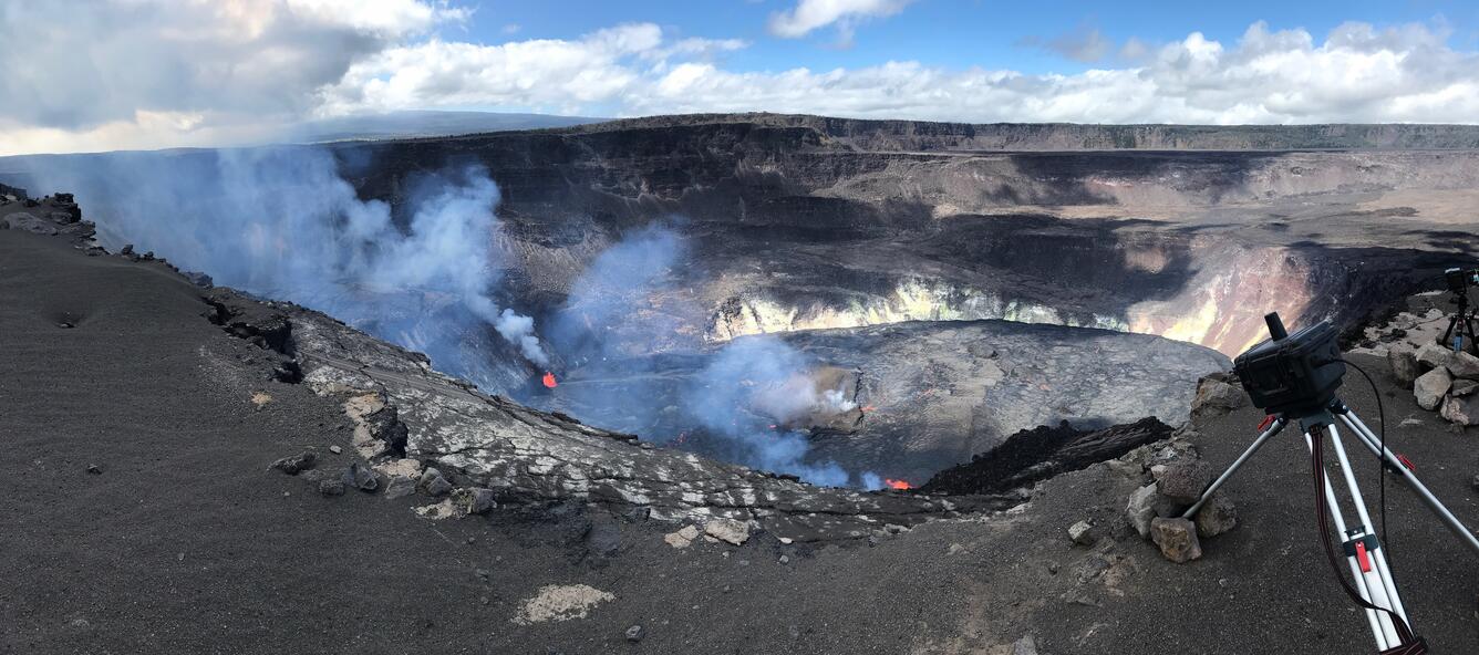
A new eruption at Kīlauea's summit began at approximately 3:20 p.m. HST on September 29, 2021. Lava activity is currently confined within Halema'uma'u crater. Gas emissions and seismic activity at the summit remain elevated. HVO field crews—equipped with specialized safety gear—monitor the eruption from within the closed area of Hawai‘i V
HVO scientists collect detailed data to assess hazards and understand how the eruption is evolving at Kīlauea's summit, all of which are shared with the National Park Service and emergency managers. Access to this hazardous area is by permission from, and in coordination with, Hawai‘i Volcanoes National Park.
The USGS Hawaiian Volcano Observatory KWcam at Kīlauea's summit has captured changes within Halemaʻumaʻu crater, at Kīlauea's summit, due to the eruption that began on September 29, 2021. At approximately 3:21 pm, HST, new fissures opened at the base of Halemaʻumaʻu crater. These fissures opened east of the large island near the center of the lava lake that was active within Halemaʻumaʻu crater from December 2020 until May 2021. The first image was taken on September 29, 2021, just before the eruption began; the second image was taken the morning of October 2, 2021, and shows the continuing eruption and growing lava lake. USGS webcam images.
With permission from Hawa‘i Volcanoes National Park, Hawaiian Volcano Observatory (HVO) scientists continue to monitor the ongoing eruption within Halema‘uma‘u, at Kīlauea's summit. No significant changes have occurred over the past 24 hours. When HVO geologists are not in the field, webcameras, such as one pictured here, allow HVO staff and the public to monitor the eruption remotely. Kīlauea summit webcams are available here. USGS photo by L. DeSmither.
The eruption in Halema‘uma‘u, at Kīlauea's summit, continues as of the evening of October 2, 2021. From the south rim of Halema‘uma‘u, this image shows at least three fountaining sources in the crater. Hawaiian Volcano Observatory scientists monitoring the eruption today noted that spatter from the fountain near the southeast edge of the island in the center of the lava lake (that formed during the December 2020-May 2021 eruption) is constructing a small cone on the island. USGS photo by L. DeSmither.
Lava continues to erupt from multiple vents on the base and west wall of Halemaʻumaʻu during the evening of October 2, 2021. Kīlauea summit sulfur dioxide (SO2) emission rates remain high and were estimated at around 20,000 tonnes per day the morning of September 30, 2021. This is significantly lower than the initial emission rates of 85,000 tonnes per day that were measured just after the eruption started on the afternoon of September 29, 2021. The rate of lava lake rise has slowed since the early phase of the eruption. Over the past 24 hours, the lava lake surface has risen approximately 4 meters (4.4 yds). In total, the lava lake surface has risen approximately 24 m (26 yds) since the eruption started. Localized and discontinuous crustal foundering continues (a process by which cool lava crust on the surface of the lava lake is overridden by less-dense liquid from below causing the crust to sink into the underlying lake lava). Seismicity is stable, with few earthquakes and ongoing eruptive tremor. Summit tiltmeters continued to record slowing deflationary tilt through the last 24 hours. USGS photo by L. DeSmither.
A helicopter overflight on October 1, 2021, at approximately 10 a.m. HST allowed for aerial visual and thermal imagery to be collected of Halema‘uma‘u crater at the summit of Kīlauea. The scale of the thermal map ranges from blue to red, with blue colors indicative of cooler temperatures and red colors indicative of warmer temperatures. The dimensions of the new lava lake are 1 km (1094 yd) E-W axis and 720 m (790 yd) in N-S axis. The estimated area of the lake is about 54 hectares (134 acres). USGS map by M. Patrick.
A helicopter overflight on October 1, 2021, at approximately 10 a.m. HST allowed for aerial visual and thermal imagery to be collected of Halema‘uma‘u crater at the summit of Kīlauea. The scale of the thermal map ranges from blue to red, with blue colors indicative of cooler temperatures and red colors indicative of warmer temperatures. The dimensions of the new lava lake are 1 km (1094 yd) E-W axis and 720 m (790 yd) in N-S axis. The estimated area of the lake is about 54 hectares (134 acres). USGS map by M. Patrick.
Get Our News
These items are in the RSS feed format (Really Simple Syndication) based on categories such as topics, locations, and more. You can install and RSS reader browser extension, software, or use a third-party service to receive immediate news updates depending on the feed that you have added. If you click the feed links below, they may look strange because they are simply XML code. An RSS reader can easily read this code and push out a notification to you when something new is posted to our site.