
Chemistry of Uncontaminated Alluvial Deposits of the Cheyenne and Belle Fourche Rivers, South Dakota
Project Period: 2009-10
Cooperators: Cheyenne River Sioux Tribe, U.S. Army Corps of Engineers
Project Chief: John Stamm
Executive Summary
The Sioux Indians of the Cheyenne River Indian Reservation maintain their culture and traditions with a strong nexus to the Cheyenne River and the resources it provides. This water resource is crucial to their traditional worship practices and ways of life, even today. In 1944, Tribal lands along the Missouri and Cheyenne Rivers were acquired by the U.S. Government under the Pick-Sloan Missouri River Basin Program and in 1959 much of that land was flooded to create the reservoir for Oahe Dam. The Water Resource Development Act of 1999 (amended in 2000) returns to the Cheyenne River and Lower Brule Sioux Tribes lands managed by the U.S. Army Corps. Section 602 (j) of the Act requires a sedimentation study be conducted not later than 10 years after the date of enactment of P.L. 106-53, prior to transfer of lands. The Secretary of the Army shall: (A) complete a study of sediment contamination in the Cheyenne River, and (B) take appropriate remedial action to eliminate any public health and environmental risk posed by the contaminated sediment.
Objectives
The objective of this project is to document concentrations of metals and metalloids in sediment that existed prior to the impact of mining and other sources of contamination in the Cheyenne River. These data provide estimates of "background" or "uncontaminated" levels in alluvial sediment as transported by the Cheyenne River to the Reservation. Several proposed sites are located on alluvial terraces that pre-date mining activity in the Black Hills. Alluvial terraces with well exposed gravels are commonly several hundred feet above the active channel in the lower part of the Cheyenne River and are estimated to be late-Pleistocene to Holocene deposits. Ages of deposits will be determined using radiocarbon (if organic material is preserved) and/or optically stimulated luminescence (quartz and feldspars in sands).
- Overview
Project Period: 2009-10
Cooperators: Cheyenne River Sioux Tribe, U.S. Army Corps of Engineers
Project Chief: John StammExecutive Summary
The Sioux Indians of the Cheyenne River Indian Reservation maintain their culture and traditions with a strong nexus to the Cheyenne River and the resources it provides. This water resource is crucial to their traditional worship practices and ways of life, even today. In 1944, Tribal lands along the Missouri and Cheyenne Rivers were acquired by the U.S. Government under the Pick-Sloan Missouri River Basin Program and in 1959 much of that land was flooded to create the reservoir for Oahe Dam. The Water Resource Development Act of 1999 (amended in 2000) returns to the Cheyenne River and Lower Brule Sioux Tribes lands managed by the U.S. Army Corps. Section 602 (j) of the Act requires a sedimentation study be conducted not later than 10 years after the date of enactment of P.L. 106-53, prior to transfer of lands. The Secretary of the Army shall: (A) complete a study of sediment contamination in the Cheyenne River, and (B) take appropriate remedial action to eliminate any public health and environmental risk posed by the contaminated sediment.
Objectives
The objective of this project is to document concentrations of metals and metalloids in sediment that existed prior to the impact of mining and other sources of contamination in the Cheyenne River. These data provide estimates of "background" or "uncontaminated" levels in alluvial sediment as transported by the Cheyenne River to the Reservation. Several proposed sites are located on alluvial terraces that pre-date mining activity in the Black Hills. Alluvial terraces with well exposed gravels are commonly several hundred feet above the active channel in the lower part of the Cheyenne River and are estimated to be late-Pleistocene to Holocene deposits. Ages of deposits will be determined using radiocarbon (if organic material is preserved) and/or optically stimulated luminescence (quartz and feldspars in sands).
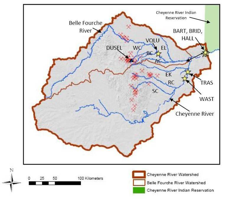
Sources/Usage: Some content may have restrictions. View Media DetailsMap of the Cheyenne River watershed showing major rivers, creeks, mining in the Black Hills (shown by the pick symbols), and the location of the Homestake Mine, which is currently occupied by the Deep Underground Science and Engineering Laboratory (DUSEL). Yellow stars show proposed sampling locations (BART, BRID, HALL, TRAS, VOLU, WAST). AC - Alkali Creek, BC - Bear Butte Creek, EK - Elk Creek, EM - Elm Creek, RC - Rapid Creek, SC - Spring Creek, WC - Whitewood Creek. - Multimedia
- Publications
- Partners