
Wyoming State Engineer’s Office and Riverside Technologies, Inc: Consumptive use Monitoring for Colorado River Compact Completed
The Colorado River provides water to seven states as well as the Republic of Mexico. The seven states which receive water from the river system are Arizona, California, Colorado, Nevada, New Mexico, Utah and Wyoming. Water is divided between these entities primarily based on three documents.
The Colorado River provides water to seven states as well as the Republic of Mexico. The seven states which receive water from the river system are Arizona, California, Colorado, Nevada, New Mexico, Utah and Wyoming. Water is divided between these entities primarily based on three documents. The Colorado River Compact signed in 1922 allocates water in the basin between the lower basin states (Arizona, California and Nevada) and the upper basin states (Colorado, New Mexico, Utah and Wyoming). The International Treaty with Mexico signed in 1944 guarantees annual delivery of 1,500,000 acre-feet of Colorado River water to that country. Finally, the Upper Colorado River Basin Compact of 1948 divides the water allocated to the upper basin states between those states on a percentage basis. Language in the Upper Basin Compact requires each upper basin state to determine and report their annual consumptive use of water.
For the State of Wyoming, this reporting obligation has historically presented a considerable challenge. The vast majority of water use in Wyoming, as with most western states, occurs due to irrigation. The portion of Wyoming that drains to the Colorado River includes the Green River Basin (fig. 1) and has over 330,000 acres of irrigated lands spread out over 17,000 square miles (mi²). In addition, water is withdrawn from surface water sources at over 2,000 individual headgates. Under these conditions, accurate on-the-ground measurement of the consumptive use of water is not only costly, but nearly impossible. In 2009, the State of Wyoming turned to the use of remotely sensed data from Landsat and a process developed in Idaho termed METRIC (Mapping EvapoTranspiration at high Resolution with Internalized Calibration; Allen and others, 2007), to assess evapotranspiration from irrigated lands in the Green River Basin (figs. 2 and 3). The METRIC model was originally developed at the University of Idaho to compute and map evapotranspiration using Landsat images. The recent Landsat satellites (5, 7, and 8) contain the necessary spatial resolution and thermal data to conduct an energy balance calculation to determine evapotranspiration at the field scale. The use of Landsat and METRIC has yielded consistent savings from a third to potentially as much as a half of the total costs compared to on-the-ground methods.

The use of Landsat data to assess the consumptive use of water across a large basin provides a savings in time and money for the State. The use of Landsat data in METRIC to estimate evapotranspiration is more efficient and accurate, as well as relatively inexpensive, when compared to traditional methods in use (Allen and others, 2005; Morse and others, 2008). The Landsat thermal band and relatively high spatial resolution are necessary for conducting energy balance analysis and determining consumptive use. Riverside Technology, inc., a private consulting firm, is currently working with the State of Wyoming by helping the state engineer’s office map consumptive use in the Green River Basin. This work is done to meet the obligation of the State of Wyoming to the Colorado River Compact administration program.

Despite the efficiencies associated with Landsat imagery use, concerns about potential problems exist. Currently there are two operating satellites: Landsat 7 and Landsat 8. Each satellite has a revisit time of 16 days, providing Landsat imagery as frequently as every 8 days. Landsat 7, however, returns an image with some missing data. Relying on imagery from Landsat 8 only, provides imagery every 16 days at best. Cloud cover on days of satellite overpass may render an image unusable, increasing the gap in imaging intervals to less than what is needed to measure evapotranspiration during a growing season. Therefore, the State of Wyoming is currently moving ahead with a program to continually measure water diverted at as many headgates as possible to ensure the state will have a “back-up” process to measure consumptive use in case of any failures in the Landsat program. This effort is expensive but necessary until an operational Landsat program can be guaranteed. Such a program would need to meet the criteria outlined by the Western States Water Council, which include ensuring the continuity of no-cost global imagery in perpetuity while retaining or improving the existing spectral bands, spatial resolution, and temporal resolution (Willardson, 2012).
Finally, although each of the upper basin states currently uses a different methodology to calculate their consumptive use, there is a study under way by the Upper Basin Commission to evaluate what it may take to conduct some monitoring of all irrigated lands in the upper basin using Landsat imagery. A consistent method across all states will hold each state accountable at the same level of accuracy and efficiency. A decision to move forward with such an effort will be based on the confidence in or certainty of a long-term Landsat program (Steve Wolff, Wyoming State Engineer’s Office, oral commun. and written commun., 2013).
- Overview
The Colorado River provides water to seven states as well as the Republic of Mexico. The seven states which receive water from the river system are Arizona, California, Colorado, Nevada, New Mexico, Utah and Wyoming. Water is divided between these entities primarily based on three documents.
The Colorado River provides water to seven states as well as the Republic of Mexico. The seven states which receive water from the river system are Arizona, California, Colorado, Nevada, New Mexico, Utah and Wyoming. Water is divided between these entities primarily based on three documents. The Colorado River Compact signed in 1922 allocates water in the basin between the lower basin states (Arizona, California and Nevada) and the upper basin states (Colorado, New Mexico, Utah and Wyoming). The International Treaty with Mexico signed in 1944 guarantees annual delivery of 1,500,000 acre-feet of Colorado River water to that country. Finally, the Upper Colorado River Basin Compact of 1948 divides the water allocated to the upper basin states between those states on a percentage basis. Language in the Upper Basin Compact requires each upper basin state to determine and report their annual consumptive use of water.
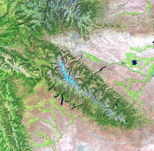
Sources/Usage: Some content may have restrictions. View Media DetailsLandsat image of the Upper Green River Basin. Courtesy of Wyoming State Engineer’s Office. For the State of Wyoming, this reporting obligation has historically presented a considerable challenge. The vast majority of water use in Wyoming, as with most western states, occurs due to irrigation. The portion of Wyoming that drains to the Colorado River includes the Green River Basin (fig. 1) and has over 330,000 acres of irrigated lands spread out over 17,000 square miles (mi²). In addition, water is withdrawn from surface water sources at over 2,000 individual headgates. Under these conditions, accurate on-the-ground measurement of the consumptive use of water is not only costly, but nearly impossible. In 2009, the State of Wyoming turned to the use of remotely sensed data from Landsat and a process developed in Idaho termed METRIC (Mapping EvapoTranspiration at high Resolution with Internalized Calibration; Allen and others, 2007), to assess evapotranspiration from irrigated lands in the Green River Basin (figs. 2 and 3). The METRIC model was originally developed at the University of Idaho to compute and map evapotranspiration using Landsat images. The recent Landsat satellites (5, 7, and 8) contain the necessary spatial resolution and thermal data to conduct an energy balance calculation to determine evapotranspiration at the field scale. The use of Landsat and METRIC has yielded consistent savings from a third to potentially as much as a half of the total costs compared to on-the-ground methods.
Sources/Usage: Some content may have restrictions. View Media DetailsLandsat 5 thermal image processed in METRIC (Mapping EvapoTranspiration at high Resolution with Internalized Calibration) of center pivot irrigated fields in Wyoming. Courtesy of Wyoming State Engineer’s Office. The use of Landsat data to assess the consumptive use of water across a large basin provides a savings in time and money for the State. The use of Landsat data in METRIC to estimate evapotranspiration is more efficient and accurate, as well as relatively inexpensive, when compared to traditional methods in use (Allen and others, 2005; Morse and others, 2008). The Landsat thermal band and relatively high spatial resolution are necessary for conducting energy balance analysis and determining consumptive use. Riverside Technology, inc., a private consulting firm, is currently working with the State of Wyoming by helping the state engineer’s office map consumptive use in the Green River Basin. This work is done to meet the obligation of the State of Wyoming to the Colorado River Compact administration program.
Sources/Usage: Some content may have restrictions. View Media DetailsPreliminary monthly evapotranspiration estimation results for the month of July along a narrow river corridor of the Green River Basin when irrigation is applied using surface water deliveries. Courtesy of Wyoming State Engineer’s Office. (METRIC, Mapping EvapoTranspiration at high Resolution with Internalized Calibration; ET, evapotranspiration; mm, millimeters) Despite the efficiencies associated with Landsat imagery use, concerns about potential problems exist. Currently there are two operating satellites: Landsat 7 and Landsat 8. Each satellite has a revisit time of 16 days, providing Landsat imagery as frequently as every 8 days. Landsat 7, however, returns an image with some missing data. Relying on imagery from Landsat 8 only, provides imagery every 16 days at best. Cloud cover on days of satellite overpass may render an image unusable, increasing the gap in imaging intervals to less than what is needed to measure evapotranspiration during a growing season. Therefore, the State of Wyoming is currently moving ahead with a program to continually measure water diverted at as many headgates as possible to ensure the state will have a “back-up” process to measure consumptive use in case of any failures in the Landsat program. This effort is expensive but necessary until an operational Landsat program can be guaranteed. Such a program would need to meet the criteria outlined by the Western States Water Council, which include ensuring the continuity of no-cost global imagery in perpetuity while retaining or improving the existing spectral bands, spatial resolution, and temporal resolution (Willardson, 2012).
Finally, although each of the upper basin states currently uses a different methodology to calculate their consumptive use, there is a study under way by the Upper Basin Commission to evaluate what it may take to conduct some monitoring of all irrigated lands in the upper basin using Landsat imagery. A consistent method across all states will hold each state accountable at the same level of accuracy and efficiency. A decision to move forward with such an effort will be based on the confidence in or certainty of a long-term Landsat program (Steve Wolff, Wyoming State Engineer’s Office, oral commun. and written commun., 2013).