
Research Geologist Adam Hudson installs a soil temperature and moisture monitoring station for a topographic asymmetry study in the Great Sand Dunes National Park and Preserve (Sangre de Cristo Mountains, Colorado, USA).
Geologic Framework of the Intermountain West Active
By Geosciences and Environmental Change Science Center
October 4, 2019
The Geologic Framework of the Intermountain West (IMW) Project is creating a seamless, integrated, geologic map database that spans the Intermountain West region. The database will serve enhanced geologic map data to support geoscience research, environmental and resource assessments, and the communication of geologic information for all U.S. Geological Survey stakeholders.
This innovative approach to serving geologic map data synthesizes new and existing geologic mapping into a spatially consistent geologic framework, preserves source metadata, and improves the queryability of map unit information. The stratigraphic framework that underpins the geologic mapping is constructed dynamically using a process-based, time-dependent, hierarchical classification of map units. This data set can be integrated with users’ data via GIS hosted feature layers or can be viewed using the Intermountain West Geologic Map Explorer .
Research groups within this project investigate the magmatic, tectonic, stratigraphic, and landscape evolution of the Intermountain West through targeted studies of geologic processes.
The Intermountain West Seamless Geologic Map Explorer is now live!
The Intermountain West Seamless Geologic Map Explorer is now live!
The Intermountain West Seamless Geologic Map Explorer is now live!
The USGS Geochron Database Explorer is now live!
The USGS Geochron Database Explorer is now live!
The USGS Geochron Database Explorer is now live!

Installing a soil temperature and moisture monitoring station
Research Geologist Adam Hudson installs a soil temperature and moisture monitoring station for a topographic asymmetry study in the Great Sand Dunes National Park and Preserve (Sangre de Cristo Mountains, Colorado, USA).

Carbonate rocks, northern Humboldt Range, Nevada
Research Geologist Amy Gilmer walks over carbonate rocks of the Upper Triassic Star Peak Group (northern Humboldt Range, Nevada, USA).
Research Geologist Amy Gilmer walks over carbonate rocks of the Upper Triassic Star Peak Group (northern Humboldt Range, Nevada, USA).

Geologic Framework of the Intermountain West Project members
Geologic Framework of the Intermountain West project members Adam Hudson, Margaret Berry, Harrison Gray, Cal Ruleman, and Samuel Johnstone perform field work for a topographic asymmetry study in the Great Sand Dunes National Park and Preserve (Sangre de Cristo Mountains, Colorado, USA).
Geologic Framework of the Intermountain West project members Adam Hudson, Margaret Berry, Harrison Gray, Cal Ruleman, and Samuel Johnstone perform field work for a topographic asymmetry study in the Great Sand Dunes National Park and Preserve (Sangre de Cristo Mountains, Colorado, USA).

Collecting sediment for geochemical analysis
In an effort to better understand the effects of abandoned mine lands on natural resources, Research Geologists Margaret Berry and Adam Hudson collect samples of ancestral Animas River sediment for geochemical analysis (Durango, Colorado, USA).
In an effort to better understand the effects of abandoned mine lands on natural resources, Research Geologists Margaret Berry and Adam Hudson collect samples of ancestral Animas River sediment for geochemical analysis (Durango, Colorado, USA).

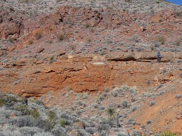
Gravel deposits and associated geologic hazards along the Hines Creek fault system, Denali National Park
linkIntermountain West Project members Adam Hudson and Michael Frothingham, in collaboration with National Park Service archaeologist Patrick Fristoe, inspect gravel deposits and associated geologic hazards along the Hines Creek fault system, Denali National Park (Alaska, USA).

Wild burros
Wild burros stand guard on the path to Miocene volcaniclastic rocks of the Death Valley region (California, USA).
Wild burros stand guard on the path to Miocene volcaniclastic rocks of the Death Valley region (California, USA).
Cenozoic fluvial conglomerates in the Delamar Mountains, Nevada
Research Geologist Jens-Erik Lundstern poses as a scale for middle Cenozoic fluvial conglomerates in the Delamar Mountains (southern Nevada, USA).
Research Geologist Jens-Erik Lundstern poses as a scale for middle Cenozoic fluvial conglomerates in the Delamar Mountains (southern Nevada, USA).

Multi-colored lacustrine shales of the Oligocene Amargosa Valley Formation
Research Geologist Jens-Erik Lundstern explores multi-colored lacustrine shales of the Oligocene Amargosa Valley Formation (Bat Mountain, California, USA).
Research Geologist Jens-Erik Lundstern explores multi-colored lacustrine shales of the Oligocene Amargosa Valley Formation (Bat Mountain, California, USA).

Cenozoic sedimentary rocks of Bat Mountain
Research Geologist Theresa Schwartz takes field notes about the Cenozoic sedimentary rocks of Bat Mountain (Death Valley region, California, USA).
Research Geologist Theresa Schwartz takes field notes about the Cenozoic sedimentary rocks of Bat Mountain (Death Valley region, California, USA).

Sedimentary rocks in Death Valley National Park
Research Geologist Theresa Schwartz walks over Cenozoic sedimentary rocks in Death Valley National Park (California, USA).
Research Geologist Theresa Schwartz walks over Cenozoic sedimentary rocks in Death Valley National Park (California, USA).

Cropsy Mountain
The flat-lying rhyolite of Cropsy Mountain overlies the hydrothermally altered Summitville Andesite (San Juan Mountains, Colorado, USA).
The flat-lying rhyolite of Cropsy Mountain overlies the hydrothermally altered Summitville Andesite (San Juan Mountains, Colorado, USA).

Sunset at Little Molas Lake, Colorado
Sunset view across Little Molas Lake, an alpine glacial lake on the west side of the Animas River Valley (San Juan Mountains, Colorado, USA).
Sunset view across Little Molas Lake, an alpine glacial lake on the west side of the Animas River Valley (San Juan Mountains, Colorado, USA).

Moab fault near Arches National Park, Utah
Geologist Alexander Lusk investigates slickenlines on the Moab fault near Arches National Park (Utah, USA).
Geologist Alexander Lusk investigates slickenlines on the Moab fault near Arches National Park (Utah, USA).

Pennsylvanian Honaker Trail Formation at Goosenecks State Park
Intermountain West Project members Theresa Schwartz and Alexander Lusk investigate the Pennsylvanian Honaker Trail Formation at Goosenecks State Park (Utah, USA).
Intermountain West Project members Theresa Schwartz and Alexander Lusk investigate the Pennsylvanian Honaker Trail Formation at Goosenecks State Park (Utah, USA).

Oligocene-Miocene Troublesome outcrop
Intermountain West Project members discuss an outcrop of the Oligocene-Miocene Troublesome Formation (near Kremmling, Colorado, USA).
Intermountain West Project members discuss an outcrop of the Oligocene-Miocene Troublesome Formation (near Kremmling, Colorado, USA).

Avery Peak, Colorado
Red sedimentary rocks of the Pennsylvanian-Permian Maroon Formation exposed on Avery Peak dip southwestward away from gray igneous rocks of the Cenozoic White Rock pluton.
Red sedimentary rocks of the Pennsylvanian-Permian Maroon Formation exposed on Avery Peak dip southwestward away from gray igneous rocks of the Cenozoic White Rock pluton.

Geologic Framework of the Intermountain West project members
Intermountain West Project members pose at the summit of Crested Butte (Colorado, USA) prior to examining the Crested Butte laccolith (from left to right, Jeremy Workman, Allison Dombrowski, Ian Hillenbrand, Amy Gilmer, Kenzie Turner, and Ren Thompson).
Intermountain West Project members pose at the summit of Crested Butte (Colorado, USA) prior to examining the Crested Butte laccolith (from left to right, Jeremy Workman, Allison Dombrowski, Ian Hillenbrand, Amy Gilmer, Kenzie Turner, and Ren Thompson).

Cottonwood Pass, Colorado
A view westward from Cottonwood Pass (Sawatch Range, Colorado, USA) into the Taylor Park basin. The peaks in the backgorund are composed of igneous and metamorphic rocks ranging in age from early Paleozoic to Eocene, uplifted along the Taylor Park fault.
A view westward from Cottonwood Pass (Sawatch Range, Colorado, USA) into the Taylor Park basin. The peaks in the backgorund are composed of igneous and metamorphic rocks ranging in age from early Paleozoic to Eocene, uplifted along the Taylor Park fault.

East Red Mountain in the Grizzly Peak caldera, Colorado
Vivid red, orange, and yellow colors highlight hydrothermally altered rocks on East Red Mountain in the Grizzly Peak caldera (Sawatch Range, Colorado, USA).
Vivid red, orange, and yellow colors highlight hydrothermally altered rocks on East Red Mountain in the Grizzly Peak caldera (Sawatch Range, Colorado, USA).

Deformed rocks of a Proterozoic shear zone
Geologist Michael Frothingham observes strongly deformed rocks of a Proterozoic shear zone in the Medicine Bow Mountains (Wyoming, USA).
Geologist Michael Frothingham observes strongly deformed rocks of a Proterozoic shear zone in the Medicine Bow Mountains (Wyoming, USA).
- Overview
The Geologic Framework of the Intermountain West (IMW) Project is creating a seamless, integrated, geologic map database that spans the Intermountain West region. The database will serve enhanced geologic map data to support geoscience research, environmental and resource assessments, and the communication of geologic information for all U.S. Geological Survey stakeholders.
This innovative approach to serving geologic map data synthesizes new and existing geologic mapping into a spatially consistent geologic framework, preserves source metadata, and improves the queryability of map unit information. The stratigraphic framework that underpins the geologic mapping is constructed dynamically using a process-based, time-dependent, hierarchical classification of map units. This data set can be integrated with users’ data via GIS hosted feature layers or can be viewed using the Intermountain West Geologic Map Explorer .
Research groups within this project investigate the magmatic, tectonic, stratigraphic, and landscape evolution of the Intermountain West through targeted studies of geologic processes.
The Intermountain West Seamless Geologic Map Explorer is now live!The Intermountain West Seamless Geologic Map Explorer is now live!The USGS Geochron Database Explorer is now live!The USGS Geochron Database Explorer is now live! - Data
- Maps
- Multimedia
Installing a soil temperature and moisture monitoring station
Research Geologist Adam Hudson installs a soil temperature and moisture monitoring station for a topographic asymmetry study in the Great Sand Dunes National Park and Preserve (Sangre de Cristo Mountains, Colorado, USA).
Research Geologist Adam Hudson installs a soil temperature and moisture monitoring station for a topographic asymmetry study in the Great Sand Dunes National Park and Preserve (Sangre de Cristo Mountains, Colorado, USA).
Carbonate rocks, northern Humboldt Range, NevadaResearch Geologist Amy Gilmer walks over carbonate rocks of the Upper Triassic Star Peak Group (northern Humboldt Range, Nevada, USA).
Research Geologist Amy Gilmer walks over carbonate rocks of the Upper Triassic Star Peak Group (northern Humboldt Range, Nevada, USA).
Geologic Framework of the Intermountain West Project membersGeologic Framework of the Intermountain West project members Adam Hudson, Margaret Berry, Harrison Gray, Cal Ruleman, and Samuel Johnstone perform field work for a topographic asymmetry study in the Great Sand Dunes National Park and Preserve (Sangre de Cristo Mountains, Colorado, USA).
Geologic Framework of the Intermountain West project members Adam Hudson, Margaret Berry, Harrison Gray, Cal Ruleman, and Samuel Johnstone perform field work for a topographic asymmetry study in the Great Sand Dunes National Park and Preserve (Sangre de Cristo Mountains, Colorado, USA).
Collecting sediment for geochemical analysisIn an effort to better understand the effects of abandoned mine lands on natural resources, Research Geologists Margaret Berry and Adam Hudson collect samples of ancestral Animas River sediment for geochemical analysis (Durango, Colorado, USA).
In an effort to better understand the effects of abandoned mine lands on natural resources, Research Geologists Margaret Berry and Adam Hudson collect samples of ancestral Animas River sediment for geochemical analysis (Durango, Colorado, USA).
Gravel deposits and associated geologic hazards along the Hines Creek fault system, Denali National ParkGravel deposits and associated geologic hazards along the Hines Creek fault system, Denali National Park
linkIntermountain West Project members Adam Hudson and Michael Frothingham, in collaboration with National Park Service archaeologist Patrick Fristoe, inspect gravel deposits and associated geologic hazards along the Hines Creek fault system, Denali National Park (Alaska, USA).
Gravel deposits and associated geologic hazards along the Hines Creek fault system, Denali National Park
linkIntermountain West Project members Adam Hudson and Michael Frothingham, in collaboration with National Park Service archaeologist Patrick Fristoe, inspect gravel deposits and associated geologic hazards along the Hines Creek fault system, Denali National Park (Alaska, USA).
Wild burrosWild burros stand guard on the path to Miocene volcaniclastic rocks of the Death Valley region (California, USA).
Wild burros stand guard on the path to Miocene volcaniclastic rocks of the Death Valley region (California, USA).
Cenozoic fluvial conglomerates in the Delamar Mountains, NevadaResearch Geologist Jens-Erik Lundstern poses as a scale for middle Cenozoic fluvial conglomerates in the Delamar Mountains (southern Nevada, USA).
Research Geologist Jens-Erik Lundstern poses as a scale for middle Cenozoic fluvial conglomerates in the Delamar Mountains (southern Nevada, USA).
Multi-colored lacustrine shales of the Oligocene Amargosa Valley FormationResearch Geologist Jens-Erik Lundstern explores multi-colored lacustrine shales of the Oligocene Amargosa Valley Formation (Bat Mountain, California, USA).
Research Geologist Jens-Erik Lundstern explores multi-colored lacustrine shales of the Oligocene Amargosa Valley Formation (Bat Mountain, California, USA).
Cenozoic sedimentary rocks of Bat MountainResearch Geologist Theresa Schwartz takes field notes about the Cenozoic sedimentary rocks of Bat Mountain (Death Valley region, California, USA).
Research Geologist Theresa Schwartz takes field notes about the Cenozoic sedimentary rocks of Bat Mountain (Death Valley region, California, USA).
Sedimentary rocks in Death Valley National ParkResearch Geologist Theresa Schwartz walks over Cenozoic sedimentary rocks in Death Valley National Park (California, USA).
Research Geologist Theresa Schwartz walks over Cenozoic sedimentary rocks in Death Valley National Park (California, USA).
Cropsy MountainThe flat-lying rhyolite of Cropsy Mountain overlies the hydrothermally altered Summitville Andesite (San Juan Mountains, Colorado, USA).
The flat-lying rhyolite of Cropsy Mountain overlies the hydrothermally altered Summitville Andesite (San Juan Mountains, Colorado, USA).
Sunset at Little Molas Lake, ColoradoSunset view across Little Molas Lake, an alpine glacial lake on the west side of the Animas River Valley (San Juan Mountains, Colorado, USA).
Sunset view across Little Molas Lake, an alpine glacial lake on the west side of the Animas River Valley (San Juan Mountains, Colorado, USA).
Moab fault near Arches National Park, UtahGeologist Alexander Lusk investigates slickenlines on the Moab fault near Arches National Park (Utah, USA).
Geologist Alexander Lusk investigates slickenlines on the Moab fault near Arches National Park (Utah, USA).
Pennsylvanian Honaker Trail Formation at Goosenecks State ParkIntermountain West Project members Theresa Schwartz and Alexander Lusk investigate the Pennsylvanian Honaker Trail Formation at Goosenecks State Park (Utah, USA).
Intermountain West Project members Theresa Schwartz and Alexander Lusk investigate the Pennsylvanian Honaker Trail Formation at Goosenecks State Park (Utah, USA).
Oligocene-Miocene Troublesome outcropIntermountain West Project members discuss an outcrop of the Oligocene-Miocene Troublesome Formation (near Kremmling, Colorado, USA).
Intermountain West Project members discuss an outcrop of the Oligocene-Miocene Troublesome Formation (near Kremmling, Colorado, USA).
Avery Peak, ColoradoRed sedimentary rocks of the Pennsylvanian-Permian Maroon Formation exposed on Avery Peak dip southwestward away from gray igneous rocks of the Cenozoic White Rock pluton.
Red sedimentary rocks of the Pennsylvanian-Permian Maroon Formation exposed on Avery Peak dip southwestward away from gray igneous rocks of the Cenozoic White Rock pluton.
Geologic Framework of the Intermountain West project membersIntermountain West Project members pose at the summit of Crested Butte (Colorado, USA) prior to examining the Crested Butte laccolith (from left to right, Jeremy Workman, Allison Dombrowski, Ian Hillenbrand, Amy Gilmer, Kenzie Turner, and Ren Thompson).
Intermountain West Project members pose at the summit of Crested Butte (Colorado, USA) prior to examining the Crested Butte laccolith (from left to right, Jeremy Workman, Allison Dombrowski, Ian Hillenbrand, Amy Gilmer, Kenzie Turner, and Ren Thompson).
Cottonwood Pass, ColoradoA view westward from Cottonwood Pass (Sawatch Range, Colorado, USA) into the Taylor Park basin. The peaks in the backgorund are composed of igneous and metamorphic rocks ranging in age from early Paleozoic to Eocene, uplifted along the Taylor Park fault.
A view westward from Cottonwood Pass (Sawatch Range, Colorado, USA) into the Taylor Park basin. The peaks in the backgorund are composed of igneous and metamorphic rocks ranging in age from early Paleozoic to Eocene, uplifted along the Taylor Park fault.
East Red Mountain in the Grizzly Peak caldera, ColoradoVivid red, orange, and yellow colors highlight hydrothermally altered rocks on East Red Mountain in the Grizzly Peak caldera (Sawatch Range, Colorado, USA).
Vivid red, orange, and yellow colors highlight hydrothermally altered rocks on East Red Mountain in the Grizzly Peak caldera (Sawatch Range, Colorado, USA).
Deformed rocks of a Proterozoic shear zoneGeologist Michael Frothingham observes strongly deformed rocks of a Proterozoic shear zone in the Medicine Bow Mountains (Wyoming, USA).
Geologist Michael Frothingham observes strongly deformed rocks of a Proterozoic shear zone in the Medicine Bow Mountains (Wyoming, USA).
- Publications
- Web Tools