
Tectonics Completed
The Southern Rocky Mountains of northern New Mexico, Colorado and southern Wyoming consist of a broad array of Proterozoic-basement-cored structural uplifts and flanking sedimentary basins. Many of these uplift-basin systems involved some degree of Late Cretaceous to Eocene crustal contraction when they initially formed during the Laramide Orogeny. Recent research has demonstrated that elements of the modern mountain-valley landscape resulted from tectonic modification of the Laramide structural framework during Oligocene to Quaternary crustal extension. Much of the extensional strain has been accommodated by normal faulting resulting in mountain block surface uplift, partly reflecting complex processes of tectonic inheritance from Proterozoic through Laramide structural features.
A Task of the Cenozoic Landscape Evolution of the Southern Rocky Mountains Project.
The mid to late Cenozoic extension may be broadly coeval with, but more spatially diffuse and regionally extensive, the discrete Rio Grande rift that transects the Southern Rocky Mountains as far north as Leadville, Colorado. For example, the broad basins of South, Middle, and North Parks may have acquired their modern topographic form chiefly by extensional modification of earlier Laramide structures. Several volcanic centers of diverse age and composition are scattered throughout the southern Rockies that may have vented along, or were otherwise influenced by, faults of similar or older age. Such structures and associations can be difficult to recognize in volcanic settings, requiring detailed mapping and field observations. Linkages between the kinematics (slip vectors) and age of young faults and the form and evolution of adjacent landscapes may exist, but they need to be systematically investigated in the Southern Rocky Mountains with the assistance of powerful new tools such as lidar and thermochronology.


Although previous research has suggested that many large-displacement and laterally extensive late Cenozoic normal faults in the Rio Grande rift and elsewhere in the Rocky Mountain region are inherited from older structures, detailed geologic data that test these claims and reveal mechanisms of structural inheritance are generally lacking. Moreover, robust criteria for testing the influence of structural inheritance are lacking.
The Laramide Orogeny in the southern Rockies has commonly been viewed as a distinct tectonic episode that was followed by a period of tectonic quiescence before latest Oligocene inception crustal extension associated with the Rio Grande rift. In contrast, recent research suggests that crustal deformation, transitional in nature between contractional (Laramide) and extensional regimes (Rio Grande rift), continued throughout late Eocene and Oligocene time. Details of this transitional tectonic phase, including temporal and spatial changes in deformational style, fault geometry, associated kinematics, and paleostress regimes have not been systematically addressed across the region.
Understanding the structural-geologic character of the present-day landscape is important for assembling the tectonic evolution of the Southern Rocky Mountains. It is also important for understanding and quantifying the natural resources that the populous of the region depends on. Refinement of our knowledge of the structural-geologic framework through mapping and topical research bears on:
- Understanding numerous resources such as groundwater aquifers and hydrocarbon and reservoirs by quantifying their physical boundary conditions—rock types, petrophysical properties, depths and lateral extents
- Identification of faults and the role they play in hosting geothermal and metallic mineral resources as well as the nature of seismic hazards they may pose
- Documentation of the current state of landscape substrates that support ecosystems that are rapidly changing


Objectives
We will characterize geologic structures as evidence for tectonic evolution and linkages to landscape change at representative locations throughout the southern Rocky Mountains. Rates of deformation and associated mountain-block rock and surface uplift will be determined in a variety of physiographic settings in rocks and deposits of diverse age using tools such as thermochronolgy. Fundamental to this research is detailed (1:50,000 and larger scale) geologic mapping of key areas to adequately document the local structural-geologic frameworks. The mapping and characterization of these frameworks, supplemented by various complementary lines of research, will help establish and assess the spatial and temporal tectonic, geologic, and landscape evolution of mountain block surface uplifts and adjacent basins and valleys over a broad region of the southern Rocky Mountains. Map and other observational data that bear directly on the relative roles of Laramide contractional versus later Cenozoic extensional deformation in controlling paleo and modern landscapes are a particular focus.


- Overview
The Southern Rocky Mountains of northern New Mexico, Colorado and southern Wyoming consist of a broad array of Proterozoic-basement-cored structural uplifts and flanking sedimentary basins. Many of these uplift-basin systems involved some degree of Late Cretaceous to Eocene crustal contraction when they initially formed during the Laramide Orogeny. Recent research has demonstrated that elements of the modern mountain-valley landscape resulted from tectonic modification of the Laramide structural framework during Oligocene to Quaternary crustal extension. Much of the extensional strain has been accommodated by normal faulting resulting in mountain block surface uplift, partly reflecting complex processes of tectonic inheritance from Proterozoic through Laramide structural features.
A Task of the Cenozoic Landscape Evolution of the Southern Rocky Mountains Project.
The mid to late Cenozoic extension may be broadly coeval with, but more spatially diffuse and regionally extensive, the discrete Rio Grande rift that transects the Southern Rocky Mountains as far north as Leadville, Colorado. For example, the broad basins of South, Middle, and North Parks may have acquired their modern topographic form chiefly by extensional modification of earlier Laramide structures. Several volcanic centers of diverse age and composition are scattered throughout the southern Rockies that may have vented along, or were otherwise influenced by, faults of similar or older age. Such structures and associations can be difficult to recognize in volcanic settings, requiring detailed mapping and field observations. Linkages between the kinematics (slip vectors) and age of young faults and the form and evolution of adjacent landscapes may exist, but they need to be systematically investigated in the Southern Rocky Mountains with the assistance of powerful new tools such as lidar and thermochronology.
Sources/Usage: Some content may have restrictions. View Media DetailsPanorama, looking west to north, of southern Sawatch Range (peaks on horizon) mountain block where it merges with the western end of "Poncha" mountain block (lower ridges in middle/foreground). South end of Upper Arkansas River Valley visible at the right edge of photo. Trace of older (Miocene?) range-front fault separating the two blocks is located where dissected bench in left middle/foreground, capped by bouldery gravel of Mio-Pliocene Dry Union Formation, intersects base of wooded escarpment (in left middle distance) formed in Paleozoic-Proterozoic basement rocks. (Credit: Scott Minor, USGS. Public domain.)
Sources/Usage: Some content may have restrictions. View Media DetailsTectonic map of the Poncha Pass area, Colorado.
Sources/Usage: Some content may have restrictions. View Media DetailsMuddy, water-saturated debris flow encountered on U.S. Highway 50 in Poncha Canyon on 15 July, 2014 about an hour after intense downpour from a localized thunder cell. Rock-laden flow was sourced from a steep, narrow tributary canyon (mouth visible in upper left part of photo) floored by loose rocky debris derived from underlying fractured Proterozoic bedrock. (Credit: Scott Minor, USGS. Public domain.) Although previous research has suggested that many large-displacement and laterally extensive late Cenozoic normal faults in the Rio Grande rift and elsewhere in the Rocky Mountain region are inherited from older structures, detailed geologic data that test these claims and reveal mechanisms of structural inheritance are generally lacking. Moreover, robust criteria for testing the influence of structural inheritance are lacking.
The Laramide Orogeny in the southern Rockies has commonly been viewed as a distinct tectonic episode that was followed by a period of tectonic quiescence before latest Oligocene inception crustal extension associated with the Rio Grande rift. In contrast, recent research suggests that crustal deformation, transitional in nature between contractional (Laramide) and extensional regimes (Rio Grande rift), continued throughout late Eocene and Oligocene time. Details of this transitional tectonic phase, including temporal and spatial changes in deformational style, fault geometry, associated kinematics, and paleostress regimes have not been systematically addressed across the region.
Understanding the structural-geologic character of the present-day landscape is important for assembling the tectonic evolution of the Southern Rocky Mountains. It is also important for understanding and quantifying the natural resources that the populous of the region depends on. Refinement of our knowledge of the structural-geologic framework through mapping and topical research bears on:
- Understanding numerous resources such as groundwater aquifers and hydrocarbon and reservoirs by quantifying their physical boundary conditions—rock types, petrophysical properties, depths and lateral extents
- Identification of faults and the role they play in hosting geothermal and metallic mineral resources as well as the nature of seismic hazards they may pose
- Documentation of the current state of landscape substrates that support ecosystems that are rapidly changing
Sources/Usage: Some content may have restrictions. View Media DetailsClose-up view of the mylonitic fault zone.
Sources/Usage: Some content may have restrictions. View Media DetailsIntensely fractured Proterozoic metamorphic basement rock exposed in Poncha Canyon. Systematic structural measurements of fractures in such old rocks indicate a protracted history of brittle deformation in the core of Poncha mountain block that continued into recent rift-related extensional faulting. (Credit: Scott Minor, USGS. Public domain.)
Sources/Usage: Some content may have restrictions. View Media DetailsTwo faults (located on either side of project geologist Chris Fridrich) cutting Pleistocene fluvial gravels on the northern edge of the Poncha mountain block. These and other young faults exposed in area help reveal the latest kinematic (movement) and paleostress histories of the mountain block. (Credit: Scott Minor, USGS. Public domain.) Objectives
We will characterize geologic structures as evidence for tectonic evolution and linkages to landscape change at representative locations throughout the southern Rocky Mountains. Rates of deformation and associated mountain-block rock and surface uplift will be determined in a variety of physiographic settings in rocks and deposits of diverse age using tools such as thermochronolgy. Fundamental to this research is detailed (1:50,000 and larger scale) geologic mapping of key areas to adequately document the local structural-geologic frameworks. The mapping and characterization of these frameworks, supplemented by various complementary lines of research, will help establish and assess the spatial and temporal tectonic, geologic, and landscape evolution of mountain block surface uplifts and adjacent basins and valleys over a broad region of the southern Rocky Mountains. Map and other observational data that bear directly on the relative roles of Laramide contractional versus later Cenozoic extensional deformation in controlling paleo and modern landscapes are a particular focus.
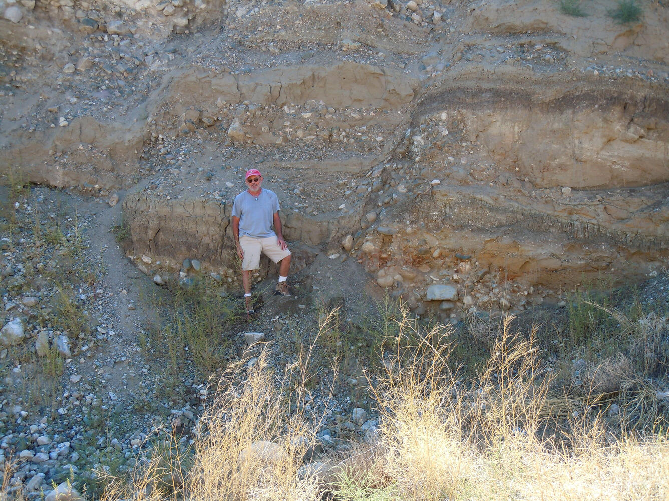
Sources/Usage: Some content may have restrictions. View Media DetailsCliff exposures of Mio-Pliocene basin-fill sediments of the Dry Union Formation along the northern front of Poncha mountain block near Salida, Colorado. An angular unconformity, visible near top of large cliff to right, separates tilted lower Dry Union gray sediments from flat-lying upper Dry Union tan gravels that are also visible in sunlit cliff cliff to left. A fault drops down the cliff sediments on the left relative to those on the right. Such relations indicate the area has been tectonically active during late stages of rifting. (Credit: Scott Minor, USGS. Public domain.)
Sources/Usage: Some content may have restrictions. View Media DetailsHoodoo in the intrarift "Poncha mountain block" (near Salida) composed of tilted sand and gravel of the Mio-Pliocene Dry Union Formation that are cut by a normal fault (white line, arrows showing slip sense). Structural measurements on faults such as this are being collected systematically to constrain the deformational and uplift histories of mountain blocks within and flanking the northern Rio Grande rift. (Credit: Scott Minor, USGS. Public domain.)
Sources/Usage: Some content may have restrictions. View Media DetailsView south along Huerfano River valley toward Blanca Peak, one of the 14,000+ ft peaks in the Sangre de Cristo Range. Project geologists and geophysicists are investigating the tectonic and structural history of this area to try to understand how it has controlled the peculiar geometry of this part of the Sangre de Cristo range front, which has influenced the location of the Great Sand Dunes. (Credit: Mark Hudson, USGS. Public domain.)