
Paleohydrology of Desert Wetlands Completed
Springs and wetlands are among the most highly threatened ecosystems on Earth. Although geographically limited, they support more than 20% of all the threatened and endangered species in the United States. Scientists from the U.S. Geological Survey are examining the rock record to determine how springs and wetlands responded to abrupt climate change during prehistoric times and the recent geologic past. The results will inform conservation efforts aimed at protecting these fragile ecosystems in light of future climate warming.
What are desert wetlands? And how do they form?
Desert wetlands occur where groundwater reaches the surface in arid environments, usually in valley bottoms and on shallow hill slopes. They include point source discharge features, such as seeps and springs, as well as more dispersed discharge, such as marshes and wet meadows. The water that feeds the springs comes from precipitation that falls on surrounding mountains, which infiltrates the rocks and eventually makes its way to the surface by natural flow or by faulting.
Wetlands are common features in deserts around the world, and support a wide array of life. When active, they serve as important watering holes for humans and animals alike, support vegetation that depends on access to groundwater for survival, and act as catchments for eolian and alluvial sediments.
Why is this research important?
Desert wetlands are among the most biologically diverse ecosystems in the world. Thousands of endangered, threatened, and endemic species all call wetlands their home. They also play an integral role in migration corridors, providing oases for animals crossing the harsh desert landscape.
Despite their ecological importance, our knowledge and understanding of springs and wetlands is extremely limited. Only a handful of the nearly 15,000 springs that have been identified in the southwestern U.S. are currently being monitored. Even fewer (virtually none) have monitoring data going back beyond the past few years. In order to understand how springs responded to climate change in the past, we need to turn to the geologic record.


How do we study wetlands that no longer exist?
Traditionally, geologists have relied heavily on lake deposits to reconstruct the magnitude and timing of environmental changes that took place in the American Southwest. Wetland deposits contain complementary information to lakes and offer several advantages. First, they provide unequivocal evidence of past water-table levels. In many instances, the elevation of past discharge can be identified to within a few centimeters. Second, they are often exposed over fairly large areas, which affords researchers the opportunity to examine and interpret complex stratigraphic relations and sedimentological features that can be missed in sediment cores. Third, they can be dated by multiple techniques and, therefore, hydrologic and climatic conditions recorded by wetlands can be tied directly to other climate records, such as ice cores, marine and lake sediments, and speleothems (cave deposits). Fourth, we can recognize specific hydrologic flow regimes in the geologic record, including rheocrene (streams), limnocrene (ponds), and helocrene (marshes) flow. Finally, they are relatively common in the world’s arid lands and can be used to reconstruct past conditions on a variety of spatial and temporal scales.

Geologic deposits associated with springs and desert wetlands can be incredibly complex, exhibiting subtle variations in color, texture, and grain size that tell us about what the landscape was like at different times in the past.
The majority of our field work is done at the outcrop scale. Sedimentary features and contacts are described in the field, and units are traced across the landscape. This can be a tricky business as some of the units are similar in appearance and are often inset within or positioned adjacent to each another.

Many of the larger wetland systems in the southern Great Basin and Mojave Deserts dried up and disappeared during the early Holocene, roughly 8,000 years ago. To understand how desert wetlands have responded to subtle changes in climate since then, we drill sediment cores near extant (or active) springs and wetlands. During wetter times, water table rise, and wetlands expand. Conversely, when conditions become dry, the water table drops, and wetlands contract or collapse altogether. These cycles can be observed in the rock record and reveal how sensitive these systems are to climate change.

How do we date the deposits?
We use two different techniques, radiocarbon and luminescence, to determine the ages of the wetland units. Radiocarbon (or 14C) dating of charcoal, small terrestrial gastropod shells, and organic matter is used to date sediments that are as much as 40,000 years old. We use luminescence dating, specifically infrared-stimulated luminescence (or IRSL), to date sediments that are beyond this limit.

And then what?
Once the stratigraphy and chronology are firmly established for a given area, we use a number of "proxy" techniques to reconstruct various aspects of the paleoenvironment.
- Microfaunal assemblages (ostracodes, mollusks), tufa morphology and lineaments, and the types of sediments and bedforms present in the geologic record allow us to reconstruct past hydrologic flow regimes.
- Stable and clumped isotopes tell us about temperature, relative humidity, and the isotopic content of groundwater in the past.
- Pollen, plant macrofossils, and charred wood provide direct evidence of the types of plants that once inhabited the area.
- Fossilized remains of extinct megafauna (mammoth, sloth, bison, horse, camel, etc.) provide opportunities to understand how faunal communities responded to past climate change in arid environments, as well as to investigate the potential ties between Pleistocene extinctions, the arrival of humans, and changes in paleoenvironmental conditions.
Results
A new way of looking at past hydrologic changes
Often thought of as stagnant and unchanging, new research suggests that springs and wetlands in the American Southwest responded dynamically to past episodes of abrupt climate change. Water tables rose and fell in response to climatic perturbations, affecting the growth and collapse of the wetlands. In the Las Vegas Valley, for example, our research group has found that wetland deposits provide a detailed and nearly complete record of dynamic hydrologic changes for the past 35,000 years, including cycles of wetland expansion, contraction, and even total ecosystem collapse when conditions became too hot/dry.

Study Locations
Recent geologic mapping by the U.S. Geological Survey has identified hundreds of localities in the southern Great Basin and Mojave Deserts that exhibit evidence of ancient springs and wetlands. Dozens, if not hundreds, of additional localities are scattered throughout the Sonoran and Chihuahuan Deserts. Scientific examination of wetland sites throughout the American Southwest will reveal important information on the sensitivity of these systems to climate change, the sources of moisture that fed the extinct wetlands, and allow us to ground truth (and thus improve) climate models.
1. Las Vegas Valley
Las Vegas is the linchpin for paleowetland studies in the southwestern U.S. The nearby mountains are exceptionally high (Mt. Charleston to the west reaches 3632 meters above sea level), which captures abundant precipitation, supplying groundwater to the valley during both glacial and interglacial periods.
Geologic research has gone on in Las Vegas for more than half a century, beginning in earnest with the "Big Dig" of 1962-63. Dr. C. Vance Haynes, Jr., directed the geologic work at that time, using large earth moving equipment to cut deep trenches to view and map the complex stratigraphic relations of the deposits without the interference of naturally eroded topography.

Geologic research in the valley resumed in the 1990s when scientists from the San Bernardino County Museum (SBCM) began working in the upper Las Vegas Wash. These efforts, which continued into the 2000’s, were initially related to paleontologic mitigation associated with Bureau of Land Management (BLM) land transfers and construction activities. Subsequent field investigations between 2008 and 2014 by the SBCM and USGS combined geologic mapping and detailed stratigraphic analyses with expanded and better-defined hydrologic interpretations and more refined chronology, resulting in the formal designations of the Las Vegas Formation and Tule Springs Local Fauna.


Ultimately, the combination of the initial protection of these fossil-rich lands by the BLM, the excitement by the general public and political powers over the fossil discoveries and ongoing scientific studies, and an enthusiastic and steadfast advocacy group led to the designation of Tule Springs Fossil Beds National Monument (or TUSK) in 2014. The designation protects these lands in perpetuity.

2. Casting the net wider—southern Great Basin and Mojave Deserts
We are able to recognize many units within the Las Vegas Formation in wetland deposits elsewhere in the southern Great Basin and Mojave Deserts, including Valley Wells, Piute Valley, Mesquite Spring, Lathrop Wells, and Dove Spring. Ongoing studies are aimed at determining if local watersheds responded in unison to changes in climate over regional spatial scales.

3. And wider still—Sonoran and Chihuahuan Deserts
Wetlands in southeastern Arizona, near the border between the Sonoran and Chihuahuan Deserts, exhibit many of the same features as those seen at sites far to the west. By comparing the magnitude and timing of changes in the local water tables to those in the southern Great Basin and Mojave Deserts, we may be able to determine the relative contributions of westerly and southerly moisture sources, a key unknown in modeling hydrologic conditions in the past.

Key unanswered questions
We are now studying similar deposits at sites throughout the southwestern U.S. to determine how local watersheds responded to past changes in climate on both local and regional scales. Our goal is to be able to provide answers to several outstanding questions:
- How sensitive are desert wetlands to climate change and at what temporal resolution can we detect this change?
- What made wetland ecosystems collapse entirely at times during the late Pleistocene? And how long were they absent from the landscape before they were reactivated?
- What were conditions like when they became active again?
- What types of hydrologic conditions and subsurface structures dictate spring development?
- Were springs and desert wetlands still around during the Holocene?
- How did wetlands respond to recent climatic events, such as the Little Ice Age?
- How might active springs respond to future climate change?
- What does this tell us about arid land springs and wetlands in other parts of the world?
- Overview
Springs and wetlands are among the most highly threatened ecosystems on Earth. Although geographically limited, they support more than 20% of all the threatened and endangered species in the United States. Scientists from the U.S. Geological Survey are examining the rock record to determine how springs and wetlands responded to abrupt climate change during prehistoric times and the recent geologic past. The results will inform conservation efforts aimed at protecting these fragile ecosystems in light of future climate warming.
What are desert wetlands? And how do they form?
Desert wetlands occur where groundwater reaches the surface in arid environments, usually in valley bottoms and on shallow hill slopes. They include point source discharge features, such as seeps and springs, as well as more dispersed discharge, such as marshes and wet meadows. The water that feeds the springs comes from precipitation that falls on surrounding mountains, which infiltrates the rocks and eventually makes its way to the surface by natural flow or by faulting.
Wetlands are common features in deserts around the world, and support a wide array of life. When active, they serve as important watering holes for humans and animals alike, support vegetation that depends on access to groundwater for survival, and act as catchments for eolian and alluvial sediments.
Why is this research important?
Desert wetlands are among the most biologically diverse ecosystems in the world. Thousands of endangered, threatened, and endemic species all call wetlands their home. They also play an integral role in migration corridors, providing oases for animals crossing the harsh desert landscape.
Despite their ecological importance, our knowledge and understanding of springs and wetlands is extremely limited. Only a handful of the nearly 15,000 springs that have been identified in the southwestern U.S. are currently being monitored. Even fewer (virtually none) have monitoring data going back beyond the past few years. In order to understand how springs responded to climate change in the past, we need to turn to the geologic record.
Sources/Usage: Public Domain. View Media DetailsPoint of Rocks Spring at Ash Meadows, southern Nevada. This spring and others like it in the arid Southwest are home to threatened and endangered species. (Photograph courtesy of Jeff Pigati.)
Sources/Usage: Some content may have restrictions. View Media DetailsA spring pool that was active ~50,000 years ago is preserved in the geologic record in the Las Vegas Valley, Nevada. Note that the green-colored sediments are shaped like a cauldron, similar to the active spring pools at Ash Meadows. (Photograph courtesy of Eric Scott.)
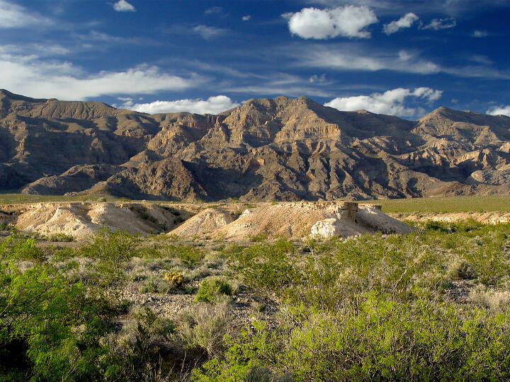
Sources/Usage: Some content may have restrictions. View Media DetailsIn southern Nevada, buff-colored deposits sit against the backdrop of the Las Vegas Range just outside the city limits of Las Vegas. Once thought to be remnants of a large lake, these deposits actually record the presence of extensive wetlands that were home to an array of Pleistocene megafauna. They also hold valuable clues to understanding how desert ecosystems responded to climate change in the past. (Photograph courtesy of Eric Scott.) How do we study wetlands that no longer exist?
Traditionally, geologists have relied heavily on lake deposits to reconstruct the magnitude and timing of environmental changes that took place in the American Southwest. Wetland deposits contain complementary information to lakes and offer several advantages. First, they provide unequivocal evidence of past water-table levels. In many instances, the elevation of past discharge can be identified to within a few centimeters. Second, they are often exposed over fairly large areas, which affords researchers the opportunity to examine and interpret complex stratigraphic relations and sedimentological features that can be missed in sediment cores. Third, they can be dated by multiple techniques and, therefore, hydrologic and climatic conditions recorded by wetlands can be tied directly to other climate records, such as ice cores, marine and lake sediments, and speleothems (cave deposits). Fourth, we can recognize specific hydrologic flow regimes in the geologic record, including rheocrene (streams), limnocrene (ponds), and helocrene (marshes) flow. Finally, they are relatively common in the world’s arid lands and can be used to reconstruct past conditions on a variety of spatial and temporal scales.
Sources/Usage: Some content may have restrictions. View Media DetailsPaleowetland deposits in the Las Vegas Valley. Through careful study, USGS scientists are able to reconstruct the hydrologic response of desert wetlands to climate change on a variety of temporal and spatial scales. (Photograph courtesy of Eric Scott.) Geologic deposits associated with springs and desert wetlands can be incredibly complex, exhibiting subtle variations in color, texture, and grain size that tell us about what the landscape was like at different times in the past.
The majority of our field work is done at the outcrop scale. Sedimentary features and contacts are described in the field, and units are traced across the landscape. This can be a tricky business as some of the units are similar in appearance and are often inset within or positioned adjacent to each another.
Sources/Usage: Some content may have restrictions. View Media DetailsUSGS geologist Kathleen Springer investigating wetland deposits in the Las Vegas Valley. (Photograph courtesy of Eric Scott.) Many of the larger wetland systems in the southern Great Basin and Mojave Deserts dried up and disappeared during the early Holocene, roughly 8,000 years ago. To understand how desert wetlands have responded to subtle changes in climate since then, we drill sediment cores near extant (or active) springs and wetlands. During wetter times, water table rise, and wetlands expand. Conversely, when conditions become dry, the water table drops, and wetlands contract or collapse altogether. These cycles can be observed in the rock record and reveal how sensitive these systems are to climate change.
Sources/Usage: Some content may have restrictions. View Media DetailsUSGS scientists collecting sediment cores near an active spring adjacent to Soda Lake in the Mojave National Preserve, southern California. (Photograph courtesy of Jeff Pigati.) How do we date the deposits?
We use two different techniques, radiocarbon and luminescence, to determine the ages of the wetland units. Radiocarbon (or 14C) dating of charcoal, small terrestrial gastropod shells, and organic matter is used to date sediments that are as much as 40,000 years old. We use luminescence dating, specifically infrared-stimulated luminescence (or IRSL), to date sediments that are beyond this limit.
Sources/Usage: Some content may have restrictions. View Media DetailsUSGS geologist Jeff Pigati collecting a sample for luminescence dating in the Las Vegas Valley. (Photograph courtesy of Kathleen Springer.) And then what?
Once the stratigraphy and chronology are firmly established for a given area, we use a number of "proxy" techniques to reconstruct various aspects of the paleoenvironment.
- Microfaunal assemblages (ostracodes, mollusks), tufa morphology and lineaments, and the types of sediments and bedforms present in the geologic record allow us to reconstruct past hydrologic flow regimes.
- Stable and clumped isotopes tell us about temperature, relative humidity, and the isotopic content of groundwater in the past.
- Pollen, plant macrofossils, and charred wood provide direct evidence of the types of plants that once inhabited the area.
- Fossilized remains of extinct megafauna (mammoth, sloth, bison, horse, camel, etc.) provide opportunities to understand how faunal communities responded to past climate change in arid environments, as well as to investigate the potential ties between Pleistocene extinctions, the arrival of humans, and changes in paleoenvironmental conditions.
Results
A new way of looking at past hydrologic changes
Often thought of as stagnant and unchanging, new research suggests that springs and wetlands in the American Southwest responded dynamically to past episodes of abrupt climate change. Water tables rose and fell in response to climatic perturbations, affecting the growth and collapse of the wetlands. In the Las Vegas Valley, for example, our research group has found that wetland deposits provide a detailed and nearly complete record of dynamic hydrologic changes for the past 35,000 years, including cycles of wetland expansion, contraction, and even total ecosystem collapse when conditions became too hot/dry.
Sources/Usage: Public Domain. View Media DetailsTypes of groundwater discharge in the Las Vegas Valley compared to isotopic values from the Greenland ice core record (higher isotopic values to the right represent warmer conditions; lower values represent cooler conditions). Wetland expansion and contraction in the Las Vegas Valley marched in virtual lockstep with short-lived, northern hemispheric climate oscillations, including Dansgaard-Oeschger (D-O) cycles, the Bølling (B) and Allerød (A) warm periods, and the Younger Dryas cold event (YD). (USGS Professional Paper 1839) Study Locations
Recent geologic mapping by the U.S. Geological Survey has identified hundreds of localities in the southern Great Basin and Mojave Deserts that exhibit evidence of ancient springs and wetlands. Dozens, if not hundreds, of additional localities are scattered throughout the Sonoran and Chihuahuan Deserts. Scientific examination of wetland sites throughout the American Southwest will reveal important information on the sensitivity of these systems to climate change, the sources of moisture that fed the extinct wetlands, and allow us to ground truth (and thus improve) climate models.
1. Las Vegas Valley
Las Vegas is the linchpin for paleowetland studies in the southwestern U.S. The nearby mountains are exceptionally high (Mt. Charleston to the west reaches 3632 meters above sea level), which captures abundant precipitation, supplying groundwater to the valley during both glacial and interglacial periods.
Geologic research has gone on in Las Vegas for more than half a century, beginning in earnest with the "Big Dig" of 1962-63. Dr. C. Vance Haynes, Jr., directed the geologic work at that time, using large earth moving equipment to cut deep trenches to view and map the complex stratigraphic relations of the deposits without the interference of naturally eroded topography.
Sources/Usage: Some content may have restrictions. View Media DetailsPhotograph from inside of one of the trenches as it appeared shortly after excavation during the Big Dig of 1962-63. Ten trenches totaling more than 2.13 km in length were excavated, including Trench K, which itself was more than a kilometer long! USGS scientists continue to refine the geologic and chronologic frameworks that Dr. Haynes established. (Photograph courtesy of the San Bernardino County Museum.) Geologic research in the valley resumed in the 1990s when scientists from the San Bernardino County Museum (SBCM) began working in the upper Las Vegas Wash. These efforts, which continued into the 2000’s, were initially related to paleontologic mitigation associated with Bureau of Land Management (BLM) land transfers and construction activities. Subsequent field investigations between 2008 and 2014 by the SBCM and USGS combined geologic mapping and detailed stratigraphic analyses with expanded and better-defined hydrologic interpretations and more refined chronology, resulting in the formal designations of the Las Vegas Formation and Tule Springs Local Fauna.
Sources/Usage: Some content may have restrictions. View Media DetailsSpectacular paleowetland deposits in the Las Vegas Valley that formed in vast marshes that spanned much of the valley ~ 30,000 years ago, a time when glaciers covered large parts of North America. (Photograph courtesy of Eric Scott.)
Sources/Usage: Some content may have restrictions. View Media DetailsBones of a juvenile Columbian mammoth eroding out of sediments dating to ~14,400 years before present. In all, SBCMscientists discovered and collected more than 500 fossil localities and curated 20,000+ fossils from the upper Las Vegas Wash. (Photograph courtesy of Eric Scott.) Ultimately, the combination of the initial protection of these fossil-rich lands by the BLM, the excitement by the general public and political powers over the fossil discoveries and ongoing scientific studies, and an enthusiastic and steadfast advocacy group led to the designation of Tule Springs Fossil Beds National Monument (or TUSK) in 2014. The designation protects these lands in perpetuity.
Sources/Usage: Some content may have restrictions. View Media DetailsA "carbonate river frozen in time." In the upper Las Vegas Wash, a braided fluvial tufa system that is unique in North America preserves rivers and streams that last flowed more than 12,000 years ago. This tufa system is just one of many of the geological wonders that make up the new national monument. (Photograph courtesy of Craig Manker.) 2. Casting the net wider—southern Great Basin and Mojave Deserts
We are able to recognize many units within the Las Vegas Formation in wetland deposits elsewhere in the southern Great Basin and Mojave Deserts, including Valley Wells, Piute Valley, Mesquite Spring, Lathrop Wells, and Dove Spring. Ongoing studies are aimed at determining if local watersheds responded in unison to changes in climate over regional spatial scales.
Sources/Usage: Some content may have restrictions. View Media DetailsWetland deposits at Valley Wells, California that recorded alternating wet (green/gray) and dry (tan/brown) cycles similar to those observed in Las Vegas Valley. (Photograph courtesy of Jeff Pigati.) 3. And wider still—Sonoran and Chihuahuan Deserts
Wetlands in southeastern Arizona, near the border between the Sonoran and Chihuahuan Deserts, exhibit many of the same features as those seen at sites far to the west. By comparing the magnitude and timing of changes in the local water tables to those in the southern Great Basin and Mojave Deserts, we may be able to determine the relative contributions of westerly and southerly moisture sources, a key unknown in modeling hydrologic conditions in the past.
Sources/Usage: Public Domain. View Media DetailsWetland deposits at the Murray Springs Paleoindian Site in southeastern Arizona. Megafaunal remains and Clovis-age artifacts dating to ~13,000 years before present have been found under the dark "black mat" layer near the middle of the exposure (just above the white Coro Marl), marking a time of significant climatic, faunal, and human transition in North America. Key unanswered questions
We are now studying similar deposits at sites throughout the southwestern U.S. to determine how local watersheds responded to past changes in climate on both local and regional scales. Our goal is to be able to provide answers to several outstanding questions:
- How sensitive are desert wetlands to climate change and at what temporal resolution can we detect this change?
- What made wetland ecosystems collapse entirely at times during the late Pleistocene? And how long were they absent from the landscape before they were reactivated?
- What were conditions like when they became active again?
- What types of hydrologic conditions and subsurface structures dictate spring development?
- Were springs and desert wetlands still around during the Holocene?
- How did wetlands respond to recent climatic events, such as the Little Ice Age?
- How might active springs respond to future climate change?
- What does this tell us about arid land springs and wetlands in other parts of the world?
- Publications
- Partners