
Sustainable Landscapes Active
Evidence of the loss and fragmentation of forest, wetland, shrubland, grassland and other natural and semi-natural cover to human activities is pervasive. In response, this study focuses on the trajectory of land use and development coupled with the capacity for landscape conservation and recovery of natural and semi-natural land cover across a diversity of U.S. landscapes.
Understanding Land-Use Trends, Development, and the Capacity for Sustainable Landscapes
Given the intense pressure from an increasing human population and parallel environmental changes, there is a need to understand the dynamics of landscape conservation and the emerging capacity for sustainable socio-ecological interaction. Issues include afforestation and forest persistence, maintenance of productive agricultural systems, ecological restoration and recovery, and changes at the urban fringe.
Landscapes are sustainable and resilient to varying degrees. However, opportunities to meet both land conservation goals and the other economic and natural resource needs of people become more challenging as population and development increase, and environmental conditions change. Although the US enjoyed historical periods of forest and grassland recovery, including during the 20th century, these types of processes and transitions may be less likely during the 21st century as population and global pressures mount. For example, the Food and Agriculture Organization of the United Nations estimates that a substantial increase in food production is needed by 2050, which may require agricultural expansion and other landscape changes.
The long-term patterns of land use development are likely reshaping the potential for landscape conservation and sustainability in a highly variable way:
How do the trajectories and processes of land use change that occur across a diversity of landscapes and climate conditions affect the capacity to retain forests, shrublands, grasslands, wetlands and environmental services, as well as to maintain economic production from agriculture, silviculture, and other productive systems?
Landscape Recovery Examples


Development trajectories and the capacity for landscape recovery and sustainability
The Sustainable Landscapes Project is investigating conditions across the US representative of a range of socioecological trajectories of development and conservation. Several comparative studies are underway in Environmental Protection Agency level IV ecoregions, including in urban landscapes of the southern coastal plains (below):

Baton Rouge Terrace: The Baton Rouge Terrace ecoregion occurs on the Pleistocene Prairie Terraces. The soils are mostly Alfisols with brown or grayish-brown, silt loam surfaces that developed in loess parent materials. High-sodium soils are common. The natural vegetation was influenced by the unusual soil conditions and by different forest types occurring in adjacent regions, with some upland hardwoods to the northwest, hardwood flatwoods and spruce pine-hardwood mixed forests across extensive broad flats, and many areas of bottomland hardwoods. Large areas of the mixed pine-hardwood forest have been cleared for pasture, cropland, and urban uses. Urban uses cover about fifty percent of the region. [From, Omernik, J.M., and Griffith, G.E., 2008, Ecoregions of Louisiana (EPA)]

Miami Ridge: The Miami Ridge/Atlantic Coastal Strip is a heavily urbanized region, sea level to 25 feet in elevation, with coastal ridges on the east and flatter terrain to the west that grades into the Everglades. The western side originally had wet and dry prairie marshes on marl and rockland and sawgrass marshes, but much of it is now covered by cropland, pasture, and suburbs. To the south, the Miami Ridge extends from near Hollywood south to Homestead and west into Long Pine Key of Everglades National Park. It is a gently rolling rock ridge of oolitic limestone that once supported more extensive southern slash pine forests and islands of tropical hardwood hammocks. The northern part of the region is a plain of pine flatwoods and wet prairie, and coastal sand ridges with scrub vegetation and sand pine. From, Griffith, G,E., Omernik, J.M., (Lead Authors); McGinley, M., (Topic Editor), 2008, Ecoregions of Florida (EPA), in Cleveland, C.J., ed., Encyclopedia of Earth: Washington, D.C., Environmental Information Coalition, National Council for Science and the Environment, first published October 16, 2008; last revised December 11, 2008]

Lower Rio Grande Valley: The Lower Rio Grande Valley ecoregion once supported dense, diverse grassland and shrub communities and low woodlands. However, mesquite, granjeno, and a variety of brush and shrub species invaded the landscape. Now, it is almost all in cropland, pasture, and urban land cover. The region is underlain by a mix of Quaternary clays and sands with some Miocene-age sediments of the Goliad Formation at the western edge. Mollisols are extensive, and the soils are deep, mostly clay loams and sandy clay loams. The freeze-free growing season is commonly more than 320 days compared to 250-260 days along the northern Texas coastal area. The Lower Rio Grande Valley contains important nesting grounds for the white-winged dove, a favored hunting species in southern Texas. [From, Omernik, J.M., and Griffith, G.E., 2013, Ecoregions of Texas (EPA)]
The Lower Rio Grande Alluvial Floodplain ecoregion includes the Holocene-age alluvial sands and clays of the Rio Grande floodplain that are now almost completely in cropland or urban land cover. The soils, mostly Vertisols and Mollisols, are deep, loamy and clayey. Some Entisols and Inceptisols occur near the river. The floodplain ridges once had abundant palm trees, and early Spanish explorers called the river "Rio de las Palmas." Most large palm trees and floodplain forests had been cleared by the early 1900's. A few small pieces of unique floodplain forests remain, including Texas ebony, Texas palmetto, and sugar hackberry-cedar elm floodplain forests. It is the most subtropical climate of Texas, but hard freezes occasionally occur, affecting plants and animals that are at the northern limit of their range. Crops include cotton, citrus, grain sorghum, sugar cane, vegetables, and melons. The Rio Grande's water is mostly diverted from its channel for irrigation and urban use, and little or no flow reaches the Gulf of Mexico. Both the Central and Mississippi flyways funnel through the southern tip of Texas and many species of birds reach their extreme northernmost range in this region. In addition, subtropical, temperate, coastal, and desert influences converge here, allowing for great species diversity. Nearly 500 bird species, including neotropical migratory birds, shorebirds, raptors, and waterfowl, can be found here. [From, Omernik, J.M., and Griffith, G.E., 2013, Ecoregions of Texas (EPA)]

Other Sustainable Landscapes research underway at GECSC
- Modes of Landscape Recovery: As population and development increase, and environmental conditions change, opportunities to meet both nature conservation goals and human needs become more imperative.
- Land Conservation Trends in Agricultural Landscapes: What is the emerging capacity for landscape conservation and recovery as socioeconomic and environmental conditions change?
- Overview
Evidence of the loss and fragmentation of forest, wetland, shrubland, grassland and other natural and semi-natural cover to human activities is pervasive. In response, this study focuses on the trajectory of land use and development coupled with the capacity for landscape conservation and recovery of natural and semi-natural land cover across a diversity of U.S. landscapes.
Understanding Land-Use Trends, Development, and the Capacity for Sustainable Landscapes
Given the intense pressure from an increasing human population and parallel environmental changes, there is a need to understand the dynamics of landscape conservation and the emerging capacity for sustainable socio-ecological interaction. Issues include afforestation and forest persistence, maintenance of productive agricultural systems, ecological restoration and recovery, and changes at the urban fringe.
Landscapes are sustainable and resilient to varying degrees. However, opportunities to meet both land conservation goals and the other economic and natural resource needs of people become more challenging as population and development increase, and environmental conditions change. Although the US enjoyed historical periods of forest and grassland recovery, including during the 20th century, these types of processes and transitions may be less likely during the 21st century as population and global pressures mount. For example, the Food and Agriculture Organization of the United Nations estimates that a substantial increase in food production is needed by 2050, which may require agricultural expansion and other landscape changes.
The long-term patterns of land use development are likely reshaping the potential for landscape conservation and sustainability in a highly variable way:
How do the trajectories and processes of land use change that occur across a diversity of landscapes and climate conditions affect the capacity to retain forests, shrublands, grasslands, wetlands and environmental services, as well as to maintain economic production from agriculture, silviculture, and other productive systems?
Landscape Recovery Examples
Sources/Usage: Some content may have restrictions. View Media DetailsAgriculture to woody wetland: Note that the recovery is paired with expanded low-density development in the north. Florida: 1989, 2002, 2014. (2002 and 2014 images taken from Google Earth)
Sources/Usage: Some content may have restrictions. View Media DetailsAgriculture to forest: Lake Champlain, Vermont: c. 1950, 2010. (2010 image taken from Google Earth)
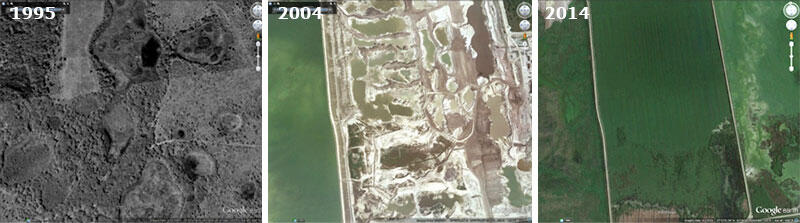
Sources/Usage: Some content may have restrictions. View Media DetailsWetland to mining to reclaimed wetland: Central Florida: 1995, 2004, 2014. (2004 and 2014 images taken from Google Earth)(Public domain.) Development trajectories and the capacity for landscape recovery and sustainability
The Sustainable Landscapes Project is investigating conditions across the US representative of a range of socioecological trajectories of development and conservation. Several comparative studies are underway in Environmental Protection Agency level IV ecoregions, including in urban landscapes of the southern coastal plains (below):
Sources/Usage: Some content may have restrictions. View Media DetailsConceptual diagram of the general approach used to understand recent landscape trajectory. Baton Rouge Terrace: The Baton Rouge Terrace ecoregion occurs on the Pleistocene Prairie Terraces. The soils are mostly Alfisols with brown or grayish-brown, silt loam surfaces that developed in loess parent materials. High-sodium soils are common. The natural vegetation was influenced by the unusual soil conditions and by different forest types occurring in adjacent regions, with some upland hardwoods to the northwest, hardwood flatwoods and spruce pine-hardwood mixed forests across extensive broad flats, and many areas of bottomland hardwoods. Large areas of the mixed pine-hardwood forest have been cleared for pasture, cropland, and urban uses. Urban uses cover about fifty percent of the region. [From, Omernik, J.M., and Griffith, G.E., 2008, Ecoregions of Louisiana (EPA)]
Sources/Usage: Some content may have restrictions. View Media DetailsBaton Rouge Terrace, Louisiana: The recent trajectory of landscape change, between 2001 and 2011 is under investigation. Miami Ridge: The Miami Ridge/Atlantic Coastal Strip is a heavily urbanized region, sea level to 25 feet in elevation, with coastal ridges on the east and flatter terrain to the west that grades into the Everglades. The western side originally had wet and dry prairie marshes on marl and rockland and sawgrass marshes, but much of it is now covered by cropland, pasture, and suburbs. To the south, the Miami Ridge extends from near Hollywood south to Homestead and west into Long Pine Key of Everglades National Park. It is a gently rolling rock ridge of oolitic limestone that once supported more extensive southern slash pine forests and islands of tropical hardwood hammocks. The northern part of the region is a plain of pine flatwoods and wet prairie, and coastal sand ridges with scrub vegetation and sand pine. From, Griffith, G,E., Omernik, J.M., (Lead Authors); McGinley, M., (Topic Editor), 2008, Ecoregions of Florida (EPA), in Cleveland, C.J., ed., Encyclopedia of Earth: Washington, D.C., Environmental Information Coalition, National Council for Science and the Environment, first published October 16, 2008; last revised December 11, 2008]
Sources/Usage: Some content may have restrictions. View Media DetailsMiami Ridge/Atlantic Coastal Strip, Florida: The recent trajectory of landscape change, between 2001 and 2011 is under investigation. Lower Rio Grande Valley: The Lower Rio Grande Valley ecoregion once supported dense, diverse grassland and shrub communities and low woodlands. However, mesquite, granjeno, and a variety of brush and shrub species invaded the landscape. Now, it is almost all in cropland, pasture, and urban land cover. The region is underlain by a mix of Quaternary clays and sands with some Miocene-age sediments of the Goliad Formation at the western edge. Mollisols are extensive, and the soils are deep, mostly clay loams and sandy clay loams. The freeze-free growing season is commonly more than 320 days compared to 250-260 days along the northern Texas coastal area. The Lower Rio Grande Valley contains important nesting grounds for the white-winged dove, a favored hunting species in southern Texas. [From, Omernik, J.M., and Griffith, G.E., 2013, Ecoregions of Texas (EPA)]
The Lower Rio Grande Alluvial Floodplain ecoregion includes the Holocene-age alluvial sands and clays of the Rio Grande floodplain that are now almost completely in cropland or urban land cover. The soils, mostly Vertisols and Mollisols, are deep, loamy and clayey. Some Entisols and Inceptisols occur near the river. The floodplain ridges once had abundant palm trees, and early Spanish explorers called the river "Rio de las Palmas." Most large palm trees and floodplain forests had been cleared by the early 1900's. A few small pieces of unique floodplain forests remain, including Texas ebony, Texas palmetto, and sugar hackberry-cedar elm floodplain forests. It is the most subtropical climate of Texas, but hard freezes occasionally occur, affecting plants and animals that are at the northern limit of their range. Crops include cotton, citrus, grain sorghum, sugar cane, vegetables, and melons. The Rio Grande's water is mostly diverted from its channel for irrigation and urban use, and little or no flow reaches the Gulf of Mexico. Both the Central and Mississippi flyways funnel through the southern tip of Texas and many species of birds reach their extreme northernmost range in this region. In addition, subtropical, temperate, coastal, and desert influences converge here, allowing for great species diversity. Nearly 500 bird species, including neotropical migratory birds, shorebirds, raptors, and waterfowl, can be found here. [From, Omernik, J.M., and Griffith, G.E., 2013, Ecoregions of Texas (EPA)]
Sources/Usage: Some content may have restrictions. View Media DetailsLower Rio Grande Valley (northern part) and Lower Rio Grande Alluvial Floodplain (southern part), Texas: The recent trajectory of change, between 2001 and 2011 is under investigation. Other Sustainable Landscapes research underway at GECSC
- Modes of Landscape Recovery: As population and development increase, and environmental conditions change, opportunities to meet both nature conservation goals and human needs become more imperative.
- Land Conservation Trends in Agricultural Landscapes: What is the emerging capacity for landscape conservation and recovery as socioeconomic and environmental conditions change?
- Publications