
Headwaters Province - Idaho and Montana: Earth Science Studies in Support of Public Policy Development and Land Stewardship Completed
The Headwaters Province project provided geoscience data and interpretations to the Federal Land Management Agencies (FLMA) that were basic to sound policy and land-stewardship practices.
Overview
The Headwaters Province project provided geoscience data and interpretations to the Federal Land Management Agencies (FLMA) that were basic to sound policy and land-stewardship practices. U.S. Forest Service (USFS) National Forest and Bureau of Land Management (BLM) Resource Area Management Plans for the Headwaters Province were in revision, with completion dates from 1999-2003. USFS Regions 1 and 4 made National Priority Requests for the Mineral Resources Program (MRP) to provide interim products that help them meet their planning cycles. MRP provided geologic maps and topical studies to meet longer range goals of integrating geoscience into decision making. This project emphasized development of digital geoscience data, GIS analyses, and interpretations to ensure that geoscience data were available for GIS-based science integration and planning.
The interrelated goals of the project were designed at complimentary scales:
- Provide digital geoscience databases for the province, at scales appropriate now and in the future, and applicable to local and regional questions.
- Advance understanding of mineral resources in a geologic, economic, and environmental context.
- Establish geologic context for ecosystem structure and function.
- Use new understanding of processes and new GIS databases to develop GIS-based approach to forecast types and locations of near future mineral exploration and development.
Project Tasks
- GIS-Based Digital Geoscience Database Development
- Geologic, Economic, and Environmental Context of Province's Mineral Deposits
- Geologic Framework for Ecosystem Structure and Function
- Digital Geologic Map Integration and Analysis
- Assessment of Potential for Development
Return to Mineral Resources Program | Geology, Geophysics, and Geochemistry Science Center
- Overview
The Headwaters Province project provided geoscience data and interpretations to the Federal Land Management Agencies (FLMA) that were basic to sound policy and land-stewardship practices.
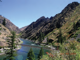
Sources/Usage: Public Domain. View Media DetailsStoddard packbridge, main Salmon River. Prominent north-dipping metamorphic layering in Mesoproterozoic biotite metasandstone on skyline. Overview
The Headwaters Province project provided geoscience data and interpretations to the Federal Land Management Agencies (FLMA) that were basic to sound policy and land-stewardship practices. U.S. Forest Service (USFS) National Forest and Bureau of Land Management (BLM) Resource Area Management Plans for the Headwaters Province were in revision, with completion dates from 1999-2003. USFS Regions 1 and 4 made National Priority Requests for the Mineral Resources Program (MRP) to provide interim products that help them meet their planning cycles. MRP provided geologic maps and topical studies to meet longer range goals of integrating geoscience into decision making. This project emphasized development of digital geoscience data, GIS analyses, and interpretations to ensure that geoscience data were available for GIS-based science integration and planning.
The interrelated goals of the project were designed at complimentary scales:
- Provide digital geoscience databases for the province, at scales appropriate now and in the future, and applicable to local and regional questions.
- Advance understanding of mineral resources in a geologic, economic, and environmental context.
- Establish geologic context for ecosystem structure and function.
- Use new understanding of processes and new GIS databases to develop GIS-based approach to forecast types and locations of near future mineral exploration and development.
Project Tasks
- GIS-Based Digital Geoscience Database Development
- Geologic, Economic, and Environmental Context of Province's Mineral Deposits
- Geologic Framework for Ecosystem Structure and Function
- Digital Geologic Map Integration and Analysis
- Assessment of Potential for Development
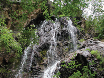
Sources/Usage: Public Domain. View Media DetailsColor Creek falls, tributary to Middle Fork Salmon River. Flowing across Mesoproterozoic muscovite-biotite schist.
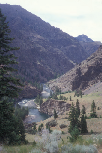
Sources/Usage: Public Domain. View Media DetailsRattlesnake Camp, Middle Fork Salmon River. Outcrops of Mesoproterozoic biotite metasandstone are prominent. Boat in mid-foreground is part of USGS–USDA Forest Service baseline geochemical characterization study of the river basin. Return to Mineral Resources Program | Geology, Geophysics, and Geochemistry Science Center
- Publications
- Partners