U.S. flag

An official website of the United States government

Geophysics

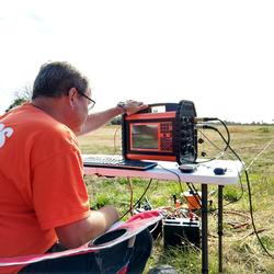
The USGS uses an integrated geologic, hydrologic, and geophysical approach to characterize the unconsolidated and bedrock aquifers in the State. Hydrogeologic framework characterization is the backbone of most groundwater-related studies, including those involving aquifer mapping, saltwater-intrusion delineation, groundwater flow and transport modeling, geologic-hazards evaluation, water-tunnel construction and repair, geothermal assessments, and groundwater-quality sampling. The NYWSC uses state-of-the-art geophysical equipment for training and methods development for geophysics that include borehole-wall imagers, gamma spectral, induction, and full waveform sonic tools, and electromagnetic and heat-pulse flowmeters. A major recent study area is the Marcellus Shale of the Appalachian Basin, one of the largest formations that contain substantial accumulations of natural gas in the United States. Processing of the Marcellus Shale deposits, which were delineated on geophysical logs by their elevated gamma radiation and low density, require hydraulic fracturing; the NYWSC has been studying water resources issues associated with development of the Marcellus Shale deposits.

Filter Total Items: 35

Water-Resource and Road-Condition Monitoring of Alternative Treatments for Road Deicing

Introduction The New York State Department of Transportation (NYSDOT) is evaluating alternative treatments for road deicing with the goal of reducing the impact of this activity on the State’s water resources. The NYSDOT has requested support from the U. S. Geological Survey (USGS) in monitoring the effects of these alternative treatments on the water resources. In the past, the USGS has cooperat
link

Water-Resource and Road-Condition Monitoring of Alternative Treatments for Road Deicing

Introduction The New York State Department of Transportation (NYSDOT) is evaluating alternative treatments for road deicing with the goal of reducing the impact of this activity on the State’s water resources. The NYSDOT has requested support from the U. S. Geological Survey (USGS) in monitoring the effects of these alternative treatments on the water resources. In the past, the USGS has cooperat
Learn More

Geophysical Methods Capabilities

Geophysics Geophysics GEOPHYSICAL METHODS CAPABILITIES The New York Water Science Center (NY WSC) makes extensive use of geophysical methods in its hydrologic investigations and research in cooperation with local, State, and Federal partners. The NY WSC staff has many years of experience in collecting and interpreting surface and borehole geophysical data, and applying the results to provide a
link

Geophysical Methods Capabilities

Geophysics Geophysics GEOPHYSICAL METHODS CAPABILITIES The New York Water Science Center (NY WSC) makes extensive use of geophysical methods in its hydrologic investigations and research in cooperation with local, State, and Federal partners. The NY WSC staff has many years of experience in collecting and interpreting surface and borehole geophysical data, and applying the results to provide a
Learn More
link

Search for New York Water Science Center Projects by County

Search for NYWSC projects by county name.
Learn More

Borehole Geophysics

Borehole geophysics is the science of recording and analyzing measurements of physical properties made in wells or test holes. Probes that measure different properties are lowered into the borehole to collect continuous or point data that is graphically displayed as a geophysical log. Multiple logs typically are collected to take advantage of their synergistic nature--much more can be learned by...
link

Borehole Geophysics

Borehole geophysics is the science of recording and analyzing measurements of physical properties made in wells or test holes. Probes that measure different properties are lowered into the borehole to collect continuous or point data that is graphically displayed as a geophysical log. Multiple logs typically are collected to take advantage of their synergistic nature--much more can be learned by...
Learn More

Determination of Sources of Water to the Tully Valley Mudboils

Background and Problem Tully Valley is part of the Onondaga Trough, which extends from the Valley Heads Moraine in the south to Onondaga Lake in the north near Syracuse, New York (fig. 1). The Onondaga Trough is filled with a complex sequence of glacial and post-glacial sediments that overlie Devonian carbonate rock and shale and Silurian shale and salt (fig.2). Mudboils, volcano-like cones o
link

Determination of Sources of Water to the Tully Valley Mudboils

Background and Problem Tully Valley is part of the Onondaga Trough, which extends from the Valley Heads Moraine in the south to Onondaga Lake in the north near Syracuse, New York (fig. 1). The Onondaga Trough is filled with a complex sequence of glacial and post-glacial sediments that overlie Devonian carbonate rock and shale and Silurian shale and salt (fig.2). Mudboils, volcano-like cones o
Learn More

Groundwater Sustainability of the Long Island Aquifer System

Groundwater sustainability can be best defined as the development and use of groundwater in a manner that can be maintained for an indefinite time without causing unacceptable environmental or socioeconomic consequences. Informed management of the Long Island aquifer system can help ensure a regionally sustainable groundwater resource. The USGS and New York State Department of Environmental...
link

Groundwater Sustainability of the Long Island Aquifer System

Groundwater sustainability can be best defined as the development and use of groundwater in a manner that can be maintained for an indefinite time without causing unacceptable environmental or socioeconomic consequences. Informed management of the Long Island aquifer system can help ensure a regionally sustainable groundwater resource. The USGS and New York State Department of Environmental...
Learn More

Hydrogeologic-Framework Mapping - Long Island, New York

Home Long Island is underlain by unconsolidated Holocene deposits, glacial deposits of Pleistocene age, and coastal-plain deposits of Late Cretaceous age. These sediments consist of gravel, sand, silt, and clay underlain by crystalline bedrock of early Paleozoic age (fig. 1). The bedrock is relatively impermeable, and forms the base of the groundwater-flow system on Long Island. The geologic and...
link

Hydrogeologic-Framework Mapping - Long Island, New York

Home Long Island is underlain by unconsolidated Holocene deposits, glacial deposits of Pleistocene age, and coastal-plain deposits of Late Cretaceous age. These sediments consist of gravel, sand, silt, and clay underlain by crystalline bedrock of early Paleozoic age (fig. 1). The bedrock is relatively impermeable, and forms the base of the groundwater-flow system on Long Island. The geologic and...
Learn More

Saltwater-Interface Mapping - Long Island, New York

Home Saltwater intrusion is the most common type of water-quality degradation in coastal-plain aquifers. In coastal areas, the hydraulic head under predevelopment (nonpumping) conditions is higher on land than in the surrounding saltwater embayments; thus, fresh groundwater flows seaward (from areas of high potential to areas of lower potential) and meets saltwater at an equilibrium point...
link

Saltwater-Interface Mapping - Long Island, New York

Home Saltwater intrusion is the most common type of water-quality degradation in coastal-plain aquifers. In coastal areas, the hydraulic head under predevelopment (nonpumping) conditions is higher on land than in the surrounding saltwater embayments; thus, fresh groundwater flows seaward (from areas of high potential to areas of lower potential) and meets saltwater at an equilibrium point...
Learn More

Groundwater-Flow Modeling - Long Island, New York

Home Numerical models provide a means to synthesize existing hydrogeologic information into an internally consistent mathematical representation of a real system or process, and thus are useful tools for testing and improving conceptual models or hypotheses of groundwater-flow systems. The goal of this effort is to develop a regional model for the Long Island aquifer system to simulate changes in...
link

Groundwater-Flow Modeling - Long Island, New York

Home Numerical models provide a means to synthesize existing hydrogeologic information into an internally consistent mathematical representation of a real system or process, and thus are useful tools for testing and improving conceptual models or hypotheses of groundwater-flow systems. The goal of this effort is to develop a regional model for the Long Island aquifer system to simulate changes in...
Learn More

Groundwater Sustainability - Long Island, New York

Home Groundwater sustainability can best be defined as the development and use of groundwater in a manner that can be maintained for an indefinite time without causing unacceptable environmental or socioeconomic consequences. Informed management of the Long Island aquifer system can help ensure a regionally sustainable groundwater resource. This study will evaluate the sustainability of Long...
link

Groundwater Sustainability - Long Island, New York

Home Groundwater sustainability can best be defined as the development and use of groundwater in a manner that can be maintained for an indefinite time without causing unacceptable environmental or socioeconomic consequences. Informed management of the Long Island aquifer system can help ensure a regionally sustainable groundwater resource. This study will evaluate the sustainability of Long...
Learn More

Our Science

The New York Water Science Center conducts research and investigations used across a broad range of industries and other services.
link

Our Science

The New York Water Science Center conducts research and investigations used across a broad range of industries and other services.
Learn More

The Use of Solute-transport Methods to Estimate Time-varying Nitrogen Loading Rates to the Peconic Estuary Resulting from Wastewater and Fertilizer Inputs to Groundwater in Suffolk County, New York (Peconic Solute Transport)

Problem The Peconic Estuary of eastern Long Island, New York, is undergoing development as the region transitions from a rural area dependent on agriculture and tourism to a suburban one with a larger year-round population. The glacial and coastal-plain sediments underlying Long Island comprise a sole-source aquifer system that supplies the region’s communities with potable water. The area surrou
link

The Use of Solute-transport Methods to Estimate Time-varying Nitrogen Loading Rates to the Peconic Estuary Resulting from Wastewater and Fertilizer Inputs to Groundwater in Suffolk County, New York (Peconic Solute Transport)

Problem The Peconic Estuary of eastern Long Island, New York, is undergoing development as the region transitions from a rural area dependent on agriculture and tourism to a suburban one with a larger year-round population. The glacial and coastal-plain sediments underlying Long Island comprise a sole-source aquifer system that supplies the region’s communities with potable water. The area surrou
Learn More