
Groundwater Sustainability - Long Island, New York Active
Home
Groundwater sustainability can best be defined as the development and use of groundwater in a manner that can be maintained for an indefinite time without causing unacceptable environmental or socioeconomic consequences. Informed management of the Long Island aquifer system can help ensure a regionally sustainable groundwater resource. This study will evaluate the sustainability of Long Island’s groundwater resource, now and for the future, by performing hydrogeologic mapping, monitoring of water quality and water levels, and constructing a groundwater-flow model for this sole-source aquifer system.
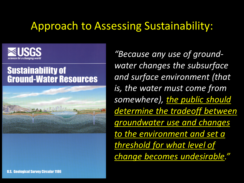
Misconceptions regarding groundwater sustainability often include the estimates of how much water is contained in the aquifer –aquifer storage – as a measure to be used to determine how much water is available for use. This example, based on the simplifying assumptions listed on the diagram, would suggest that there is about 50 trillion gallons (Tgal) of water stored in the Long Island aquifer system.
In addition to the water in storage, water is continuously entering and leaving the aquifer system as rainfall reaches the water table as recharge, and then flows through the subsurface until either discharging to streams and coastal waters, or captured and removed by pumping wells. A simplified water budget indicates that for the current (2015) pumping rate of about 150 billion gallons per year (Bgal/yr), groundwater withdrawals are only removing about 23% of the water entering the aquifer system as recharge (660 Bgal/yr), and have only resulted in about 1% of total groundwater depletion since the onset of pumping in the early 1900s (Masterson and others, 2016).
Although, the cumulative amount of groundwater depletion on Long Island may appear small (500 Bgal) compared to the total amount of water in storage (50 Tgal), removing any groundwater from storage changes the depth to the water table, and therefore, has the greatest effect on the areas where the depth to water is small; these are generally the areas where groundwater discharges to lakes, streams, wetlands, and estuaries. Small changes in water levels from groundwater depletion in these areas, can have large effects since groundwater is the primary source of water to these surface waters and is needed to support healthy ecological habitats and recreational uses.
A simple water budget is not appropriate to determine how much water can be safely removed from the aquifer system without causing unacceptable impacts to the surface waters that rely on groundwater discharge. Misuse of water budgets for this purpose have been referred to as the “Water Budget Myth”. A more appropriate approach to assessing groundwater sustainability is first to determine the factors that can limit how much water can be removed from the aquifer system. These factors include both water-quantity and water-quality considerations.
Nearly all of the water moving through the lakes and flowing in the streams on Long Island is derived from groundwater. Therefore, if the water table is lowered (or depth to water is increased) from pumping or sewering, streams and other water bodies can be adversely impacted. In western parts on Long Island, many steams and water bodies have already seen declines in groundwater discharge over the past decades, which is attributed to increased sewering and groundwater withdrawal (Busciolano, 2005). These declines have caused reduced streamflow and lake levels, and have affected the overall health of these water bodies.
The boundary between fresh groundwater and saline groundwater is referred to as the freshwater/saltwater interface. Fresh groundwater discharging to the coast prevents the landward encroachment of saline groundwater. If this balance is upset by too much water being removed from the aquifer system from pumping, then saline groundwater can migrate landward by a process referred to as saltwater intrusion. If a pumping well is close to the landward migrating freshwater/saltwater interface, the potential exists for saltwater contamination in the well.
Groundwater quality also can be a limiting factor on aquifer sustainability. All of the groundwater pumped from wells originated as recharge at land surface, therefore, the quality of the water pumped from the well can be affected by any land-use activities that can contribute contamination. Additionally, pumping of groundwater can affect the movement of contaminants in the aquifer system by altering the flow direction of water particles in the system.
Groundwater models can be used to calculate the area at the land surface that contributes water to a given pumping well; these areas are referred to as recharge or contributing areas.
Determining the sources of water to multiple pumping wells with numerous sites of point-source and nonpoint-source contamination can be very difficult, therefore, the USGS is attempting to use groundwater-age calculations to determine where in the aquifer one would find water that entered the flow system less than and greater than 100-years ago. This analysis will help determine how much water could have the potential to be affected by recent adverse land-use activities and how many public-supply wells may fall within that zone. This analysis is being supported by the USGS National Water Quality Project.
The approach to assessing groundwater sustainability involves the USGS developing the necessary modeling tools to predict the aquifer-system response to changing hydrologic stresses and working in partnership with the NYSDEC and its project steering committee to identify potential ecohydrological impacts, and whether these impacts are acceptable for modeling scenarios selected for this investigation.
Below are other science projects associated with this project.

Hydrogeologic-Framework Mapping - Long Island, New York
Saltwater-Interface Mapping - Long Island, New York

Groundwater-Flow Modeling - Long Island, New York
- Overview
Home
Groundwater sustainability can best be defined as the development and use of groundwater in a manner that can be maintained for an indefinite time without causing unacceptable environmental or socioeconomic consequences. Informed management of the Long Island aquifer system can help ensure a regionally sustainable groundwater resource. This study will evaluate the sustainability of Long Island’s groundwater resource, now and for the future, by performing hydrogeologic mapping, monitoring of water quality and water levels, and constructing a groundwater-flow model for this sole-source aquifer system.
Misconceptions regarding groundwater sustainability often include the estimates of how much water is contained in the aquifer –aquifer storage – as a measure to be used to determine how much water is available for use. This example, based on the simplifying assumptions listed on the diagram, would suggest that there is about 50 trillion gallons (Tgal) of water stored in the Long Island aquifer system.
In addition to the water in storage, water is continuously entering and leaving the aquifer system as rainfall reaches the water table as recharge, and then flows through the subsurface until either discharging to streams and coastal waters, or captured and removed by pumping wells. A simplified water budget indicates that for the current (2015) pumping rate of about 150 billion gallons per year (Bgal/yr), groundwater withdrawals are only removing about 23% of the water entering the aquifer system as recharge (660 Bgal/yr), and have only resulted in about 1% of total groundwater depletion since the onset of pumping in the early 1900s (Masterson and others, 2016).
Although, the cumulative amount of groundwater depletion on Long Island may appear small (500 Bgal) compared to the total amount of water in storage (50 Tgal), removing any groundwater from storage changes the depth to the water table, and therefore, has the greatest effect on the areas where the depth to water is small; these are generally the areas where groundwater discharges to lakes, streams, wetlands, and estuaries. Small changes in water levels from groundwater depletion in these areas, can have large effects since groundwater is the primary source of water to these surface waters and is needed to support healthy ecological habitats and recreational uses.
A simple water budget is not appropriate to determine how much water can be safely removed from the aquifer system without causing unacceptable impacts to the surface waters that rely on groundwater discharge. Misuse of water budgets for this purpose have been referred to as the “Water Budget Myth”. A more appropriate approach to assessing groundwater sustainability is first to determine the factors that can limit how much water can be removed from the aquifer system. These factors include both water-quantity and water-quality considerations.
Nearly all of the water moving through the lakes and flowing in the streams on Long Island is derived from groundwater. Therefore, if the water table is lowered (or depth to water is increased) from pumping or sewering, streams and other water bodies can be adversely impacted. In western parts on Long Island, many steams and water bodies have already seen declines in groundwater discharge over the past decades, which is attributed to increased sewering and groundwater withdrawal (Busciolano, 2005). These declines have caused reduced streamflow and lake levels, and have affected the overall health of these water bodies.
The boundary between fresh groundwater and saline groundwater is referred to as the freshwater/saltwater interface. Fresh groundwater discharging to the coast prevents the landward encroachment of saline groundwater. If this balance is upset by too much water being removed from the aquifer system from pumping, then saline groundwater can migrate landward by a process referred to as saltwater intrusion. If a pumping well is close to the landward migrating freshwater/saltwater interface, the potential exists for saltwater contamination in the well.
Groundwater quality also can be a limiting factor on aquifer sustainability. All of the groundwater pumped from wells originated as recharge at land surface, therefore, the quality of the water pumped from the well can be affected by any land-use activities that can contribute contamination. Additionally, pumping of groundwater can affect the movement of contaminants in the aquifer system by altering the flow direction of water particles in the system.
Groundwater models can be used to calculate the area at the land surface that contributes water to a given pumping well; these areas are referred to as recharge or contributing areas.
Determining the sources of water to multiple pumping wells with numerous sites of point-source and nonpoint-source contamination can be very difficult, therefore, the USGS is attempting to use groundwater-age calculations to determine where in the aquifer one would find water that entered the flow system less than and greater than 100-years ago. This analysis will help determine how much water could have the potential to be affected by recent adverse land-use activities and how many public-supply wells may fall within that zone. This analysis is being supported by the USGS National Water Quality Project.
The approach to assessing groundwater sustainability involves the USGS developing the necessary modeling tools to predict the aquifer-system response to changing hydrologic stresses and working in partnership with the NYSDEC and its project steering committee to identify potential ecohydrological impacts, and whether these impacts are acceptable for modeling scenarios selected for this investigation.
Sources/Usage: Public Domain. View Media DetailsFigure 1 - Approach to Assessing Sustainability of Groundwater Resources on Long Island. (Public domain) - Science
Below are other science projects associated with this project.
Hydrogeologic-Framework Mapping - Long Island, New York
Home Long Island is underlain by unconsolidated Holocene deposits, glacial deposits of Pleistocene age, and coastal-plain deposits of Late Cretaceous age. These sediments consist of gravel, sand, silt, and clay underlain by crystalline bedrock of early Paleozoic age (fig. 1). The bedrock is relatively impermeable, and forms the base of the groundwater-flow system on Long Island. The geologic and...Saltwater-Interface Mapping - Long Island, New York
Home Saltwater intrusion is the most common type of water-quality degradation in coastal-plain aquifers. In coastal areas, the hydraulic head under predevelopment (nonpumping) conditions is higher on land than in the surrounding saltwater embayments; thus, fresh groundwater flows seaward (from areas of high potential to areas of lower potential) and meets saltwater at an equilibrium point...Groundwater-Flow Modeling - Long Island, New York
Home Numerical models provide a means to synthesize existing hydrogeologic information into an internally consistent mathematical representation of a real system or process, and thus are useful tools for testing and improving conceptual models or hypotheses of groundwater-flow systems. The goal of this effort is to develop a regional model for the Long Island aquifer system to simulate changes in...