
High-Resolution Multichannel Seismic System Active
Description of the high-resolution multichannel seismic system at the Marine Facility (MarFac) of the USGS Pacific Coastal and Marine Science Center, for seafloor mapping

PCMSC owns and operates a portable high resolution multichannel seismic system capable of collecting sub-bottom seafloor data from a variety of vessels. The system consists of several sound sources and hydrophone receivers that can be configured for different sediment types to target subsurface structures and materials. In its smaller configuration, it can be hand deployed from small boats allowing access to shallow coastal waters. When offshore data or deeper subsurface penetration is required, the system is installed on larger ships that can supply the power, high-pressure air, and deck space needed to operate. This capability has allowed us to identify features such as submarine landslides, gas hydrates, and faults in waters of the Pacific, Atlantic, Gulf of Mexico, and Alaska.
Sound Sources

Airgun
- (1) GI Gun (210 cu. In.)
- (2) Mini GI Gun (60 cu in.)
- 4-Gun Rack-mount Hotshot Controller
- 2-Gun Portable Hotshot Controller
- Electric Compressor – MaxAir 90 PBAC with vertical storage
- Peripherals (umbilicals, blast phones, 2-gun hanger, air handling manifold)
Sparkers and Boomers
- SIG mini-sparker
- Delta Sparker
- Applied Acoustics AA201 Boomer Plate
- GeoPulse Boomer Plates
- Associated Power Supplies: Applied Acoustics
Acquisition
- Geometrics Geoeel Multichannel Streamer
- (3) Streamer depth control birds
- Electric winch with 500m capacity
Complementary Equipment
High resolution data is often collected in conjunction with a Chirp sub-bottom profiler.


.


Check out the PCMSC Marine Facility (MarFac) web site for more information about our field capabilities.

PCMSC Marine Facility (MarFac)

Cascadia Subduction Zone Marine Geohazards

PCMSC MarFac Field Equipment and Capabilities

Coastal and Marine Geohazards of the U.S. West Coast and Alaska

California Sand Resource Assessment Project

MarFac Dive Team

PCMSC MarFac Vessels
- Overview
Description of the high-resolution multichannel seismic system at the Marine Facility (MarFac) of the USGS Pacific Coastal and Marine Science Center, for seafloor mapping
Sources/Usage: Public Domain. View Media DetailsR/V Barnes with the USGS multichannel seismic system and Chirp sub-bottom profiler. PCMSC owns and operates a portable high resolution multichannel seismic system capable of collecting sub-bottom seafloor data from a variety of vessels. The system consists of several sound sources and hydrophone receivers that can be configured for different sediment types to target subsurface structures and materials. In its smaller configuration, it can be hand deployed from small boats allowing access to shallow coastal waters. When offshore data or deeper subsurface penetration is required, the system is installed on larger ships that can supply the power, high-pressure air, and deck space needed to operate. This capability has allowed us to identify features such as submarine landslides, gas hydrates, and faults in waters of the Pacific, Atlantic, Gulf of Mexico, and Alaska.
Sound Sources
Sources/Usage: Public Domain. View Media DetailsGI Gun Airgun
- (1) GI Gun (210 cu. In.)
- (2) Mini GI Gun (60 cu in.)
- 4-Gun Rack-mount Hotshot Controller
- 2-Gun Portable Hotshot Controller
- Electric Compressor – MaxAir 90 PBAC with vertical storage
- Peripherals (umbilicals, blast phones, 2-gun hanger, air handling manifold)
Sparkers and Boomers
Sources/Usage: Public Domain. View Media DetailsGeoPulse boomer plates mounted on float - SIG mini-sparker
- Delta Sparker
- Applied Acoustics AA201 Boomer Plate
- GeoPulse Boomer Plates
- Associated Power Supplies: Applied Acoustics
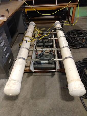
Acquisition
- Geometrics Geoeel Multichannel Streamer
- (3) Streamer depth control birds
- Electric winch with 500m capacity
Complementary Equipment
High resolution data is often collected in conjunction with a Chirp sub-bottom profiler.
Sources/Usage: Public Domain. View Media DetailsPCMSC's Geometrics GeoEel Multichannel Streamer sits on the deck of R/V Bold Horizon.
Sources/Usage: Public Domain. View Media DetailsGeoEel on its winch in the wareyard of MarFac, the USGS Pacific Coastal and Marine Science Center's marine facility. .
Sources/Usage: Public Domain. View Media DetailsThe Geospace Navigator bird is a streamer depth control device, used with a high-resolution seismic system to regulate and record the depth of the streamer.
Sources/Usage: Public Domain. View Media DetailsThe Geospace Navigator bird is a streamer depth control device, used with a high-resolution seismic system to regulate and record the depth of the streamer.
Sources/Usage: Public Domain. View Media DetailsThe Applied Acoustics power supplies provide variable output energy, up to 2400 J per shot, by means of capacitor discharge. They can be used for a range of seismic sound sources, from single boomer plates up to large sparkers. The charging rate for the CSP-D units is up to 1500 J/s. - Science
Check out the PCMSC Marine Facility (MarFac) web site for more information about our field capabilities.
PCMSC Marine Facility (MarFac)
Learn about the USGS Pacific Coastal and Marine Science Center Marine Facility, or MarFacCascadia Subduction Zone Marine Geohazards
Societal Issue: Uncertainty related to rupture extent, slip distribution, and recurrence of past subduction megathrust earthquakes in the Pacific Northwest (northern CA, OR, WA, and southern BC) leads to ambiguity in earthquake and tsunami hazard assessments and hinders our ability to prepare for future events.ByNatural Hazards Mission Area, Coastal and Marine Hazards and Resources Program, Pacific Coastal and Marine Science Center, 3-D CT Core Imaging Laboratory, Core Preparation and Analysis Laboratory and Sample Repositories, Multi-Sensor Core Logger Laboratory, Deep Sea Exploration, Mapping and Characterization, Subduction Zone SciencePCMSC MarFac Field Equipment and Capabilities
Learn about the USGS Pacific Coastal and Marine Science Center Marine Facility’s vast array of field equipment, sampling devices, and mapping systems, and our capabilities. Our engineers, designers, mechanics, and technicians have also designed and developed some of the specialized field equipment we use in field operations in the nearshore, in the deep sea, and on land.Coastal and Marine Geohazards of the U.S. West Coast and Alaska
Coastal and marine geohazards are sudden and extreme events beneath the ocean that threaten coastal populations. Such underwater hazards include earthquakes, volcanic eruptions, landslides, and tsunamis.ByNatural Hazards Mission Area, Coastal and Marine Hazards and Resources Program, Pacific Coastal and Marine Science Center, 3-D CT Core Imaging Laboratory, Core Preparation and Analysis Laboratory and Sample Repositories, Big Sur Landslides, Deep Sea Exploration, Mapping and Characterization, Subduction Zone ScienceCalifornia Sand Resource Assessment Project
The USGS is working in partnership with the Bureau of Ocean Energy Management (BOEM) and the State of California Ocean Protection Council (OPC) to evaluate sand and gravel resources in Federal and State waters for potential use in future beach nourishment projects. Prior to the leasing and development of outer continental shelf (OCS) sand resources for use in beach restoration or coastal...MarFac Dive Team
The USGS Pacific Coastal and Marine Science Center in Santa Cruz, California, maintains a certified scientific dive team.PCMSC MarFac Vessels
The USGS Pacific Coastal and Marine Science Center uses a wide variety of vessels, from kayaks to open-ocean ships, to conduct fieldwork. Most vessels are managed by our Marine Facility, or MarFac. - Data
- News