

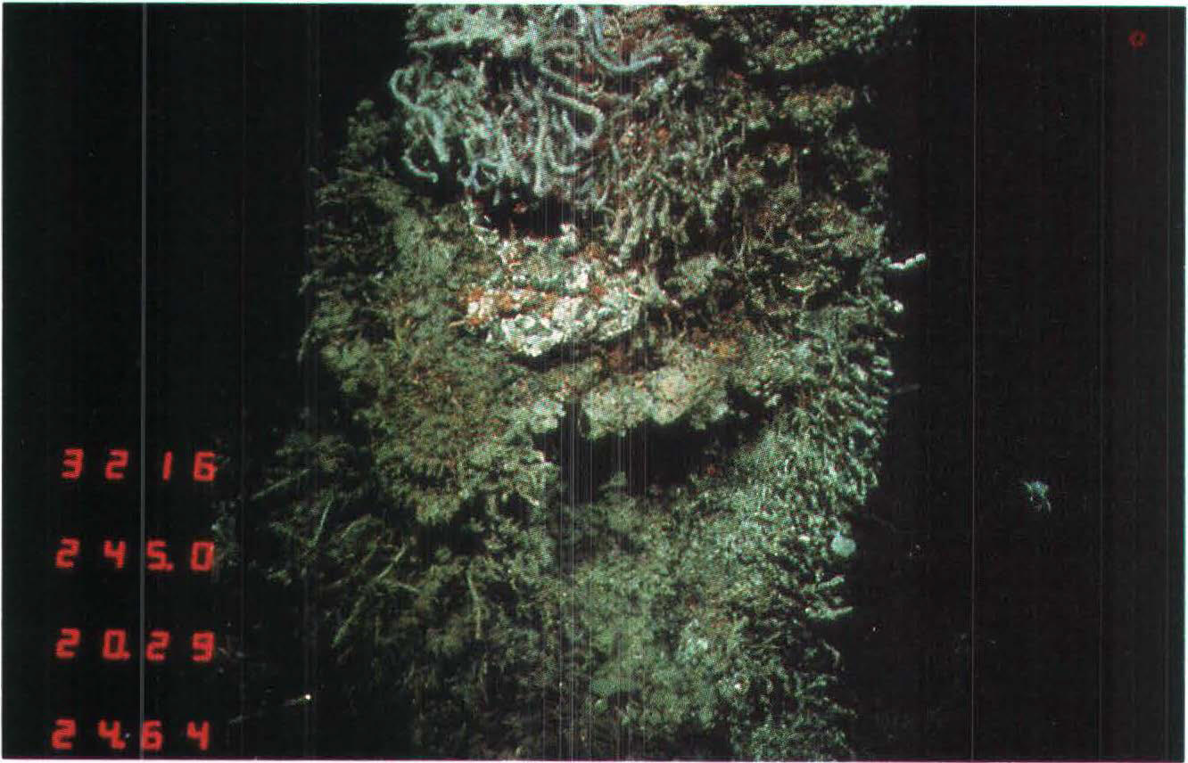
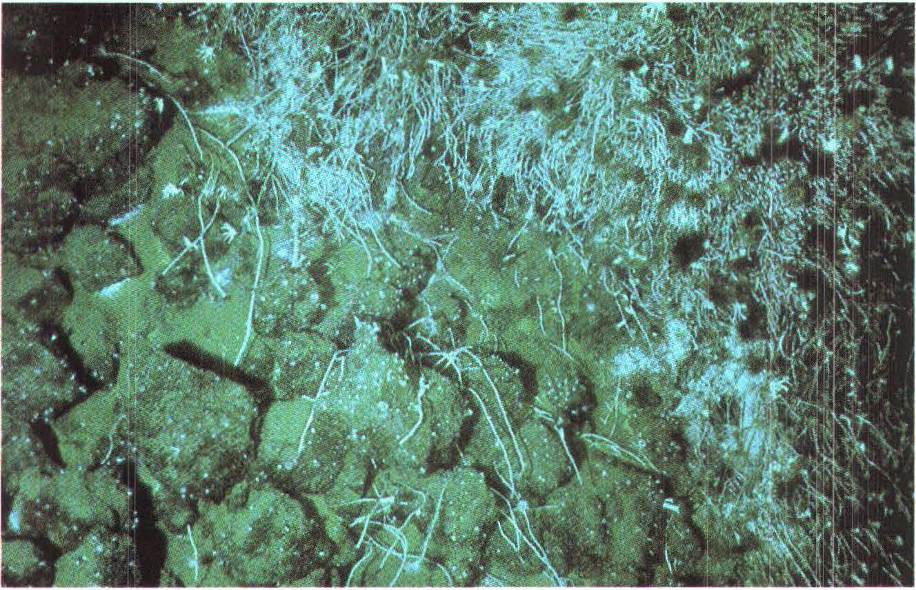
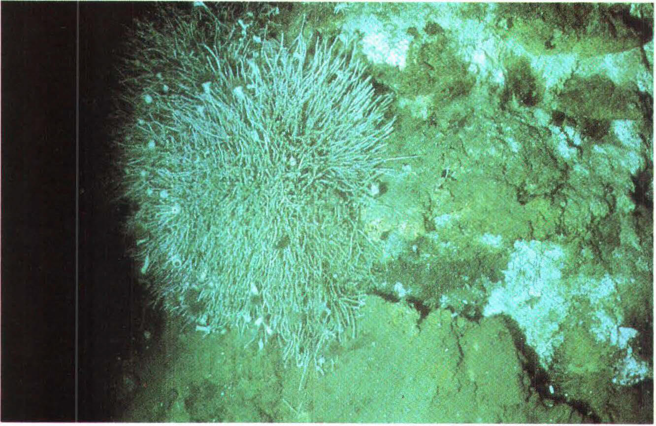
The familiar saying “good things come in small packages” holds especially true for deep-sea biological communities at hydrothermal vents, including those at Escanaba Trough, a seafloor spreading center located almost 200 miles off the northern California coast.
USGS Leads Research Expedition to Deep-sea Escanaba Trough
By Pacific Coastal and Marine Science Center
May 19, 2022
The USGS, in cooperation with BOEM, NOAA, and others, embarked on a three-week research expedition to Escanaba Trough off the coast of northern California in May-June 2022. The multidisciplinary crew collected extensive geologic, geochemical, and biological samples with the remotely operated vehicle Jason, as well as tested new seafloor mapping techniques using the autonomous underwater vehicle Se
Watch short videos about this expedition, and read deep-dive stories to learn more about the hydrothermal systems, marine geology, and critical minerals of Escanaba Trough.
Read story: Hydrothermal Systems in Escanaba Trough
Read story: Hydrothermal Systems in Escanaba Trough
Read story: Hydrothermal Systems in Escanaba Trough
Read story: Marine Geology in Escanaba Trough
Read story: Marine Geology in Escanaba Trough
Read story: Marine Geology in Escanaba Trough
Read story: Critical Mineral Resources in Escanaba Trough
Read story: Critical Mineral Resources in Escanaba Trough
Read story: Critical Mineral Resources in Escanaba Trough
Read story: Whence comes the name “Escanaba”?
Read story: Whence comes the name “Escanaba”?
Read story: Whence comes the name “Escanaba”?
Read story: Seafloor Mapping in Escanaba Trough
Read story: Seafloor Mapping in Escanaba Trough
Read story: Seafloor Mapping in Escanaba Trough
Read story: Biological Communities in Escanaba Trough
Read story: Biological Communities in Escanaba Trough
Read story: Biological Communities in Escanaba Trough
Watch Video: scientists and crew prepare for 3-week research cruise at sea
Watch Video: scientists and crew prepare for 3-week research cruise at sea
Watch Video: scientists and crew prepare for 3-week research cruise at sea
Watch Video: Get submersed and take a dive with deep-sea robots
Watch Video: Get submersed and take a dive with deep-sea robots
Watch Video: Get submersed and take a dive with deep-sea robots
Watch Video: how scientists collect and store deep-sea samples
Watch Video: how scientists collect and store deep-sea samples
Watch Video: how scientists collect and store deep-sea samples
Watch Video: Collecting sediment cores at sea
Watch Video: Collecting sediment cores at sea
Watch Video: Collecting sediment cores at sea

Sources/Usage: Public Domain. View Media Details
In May-June 2022, the U.S. Geological Survey, in cooperation with the Bureau of Ocean Energy Management (BOEM), the National Oceanic and Atmospheric Administration (NOAA), and others, embarked on a three-week research expedition to Escanaba Trough off the coast of northern California. The multidisciplinary crew collected extensive geologic, geochemical, and biological samples with the remotely operated vehicle Jason, as well as tested new seafloor mapping techniques using the autonomous underwater vehicle Sentry.
In addition to its unique geochemistry and geomorphology, Escanaba Trough is the only mid-ocean spreading center located within the U.S. Exclusive Economic Zone (EEZ). These zones extend 200 nautical miles from a country’s shores and gives that country control over the exploration and exploitation of marine resources in that area.
The USGS Global Marine Minerals Team, based out of the Pacific Coastal and Marine Science Center, led the research expedition. This team provides expertise to the U.S. regarding the geochemistry and distribution of marine minerals in the U.S. EEZ and beyond.
Escanaba Trough is a hydrothermal seafloor system located almost 200 miles off the coast of northern California. It lies at the divergence of two tectonic plates, where convection in the Earth’s mantle slowly pulls plates apart and allows new, less dense mantle material to rise, forming ridges on the seafloor.
Escanaba Trough is part of a tectonically and volcanically active plate boundary known as Gorda Ridge, a mid-ocean seafloor spreading center consisting of a deep, wide axial valley flanked by ridges. Escanaba Trough is 3,300 meters deep and 75 kilometers long. It is covered for most of this length by as much as 500 meters of sediment shed from the Pacific continental margin of the United States.
“The Escanaba Trough provides opportunities for scientists to learn details about tectonics, volcanism, mineral formation, and biological activity that are not normally observed at mid-ocean ridges,” said Randolph Koski, USGS Emeritus at the Geology, Minerals, Energy, and Geophysics Science Center. “It is a geological laboratory of grand proportions."

Sources/Usage: Public Domain. View Media Details
At Escanaba Trough, the thick sediment layer traps geothermal heat, resulting in the formation of significant amounts of sulfide minerals. These minerals form when hot water from beneath the ocean floor escapes and mixes with cold seawater. As hot water travels through various rock and sediment layers, it pulls elements such as copper, zinc, and iron along with it, slowly depositing them in minerals as the water cools.
Sulfide minerals are sources of precious metals and critical minerals including gold, silver, platinum, antimony, bismuth, lead, nickel, and zinc. Critical minerals are resources considered essential to the economic or national security of the U.S. that are also vulnerable to supply-chain disruptions.
“Any inventory of global mineral resources is incomplete without considering marine minerals, which are distributed widely across the global seafloor and vary considerably in how and where they form,” said Amy Gartman, USGS Research Oceanographer with the Pacific Coastal and Marine Science Center and Global Marine Minerals Team lead. “In addition to mineral characterization, it is crucial to understand the environmental setting of these minerals and their interactions with the surrounding ecosystem.”
While terrestrial and coastal mineral deposits have been exploited for centuries, deep-sea geologic formations containing concentrations of minerals are largely untouched. A better understanding of marine mineral resources is of growing interest to nations worldwide—particularly those minerals used in the development and application of renewable energy technologies. Solar panels, wind turbines, and batteries for electric vehicles all require critical-mineral components; the transition to renewable energy will require a shift from fuel-intensive systems to material-intensive systems.

Sources/Usage: Public Domain. View Media Details
Earlier studies in Escanaba Trough revealed the presence of polymetallic sulfide minerals that may contain high grades of gold, silver, copper, and zinc, as well as lesser amounts of metals such as antimony, bismuth, lead, cobalt, and tin.
“USGS and partners did quite a bit of research in that area in the 1980s,” Gartman said. “A lot of what we learned there has guided further research, and now it’s time for us to go back and apply what we have learned in the decades since.”
The last expedition to Escanaba Trough occurred in 2016, when researchers from the Monterey Bay Aquarium Research Institution used autonomous underwater vehicles to map the seafloor in finer detail. For the 2022 expedition, USGS worked with BOEM, NOAA, and partners to investigate the conditions leading to the enrichment of elements in sulfide minerals, and better understand the elements’ distribution in minerals and the surrounding ocean environment, including their relationship to vulnerable biological communities.
See the NOAA Ocean Explorer page for more information about the Escanaba Trough Expedition.
We hope you will join us for these discoveries by following along as the expedition progresses!
Archival photos taken during submersible dives to Escanaba Trough, 1985-1989
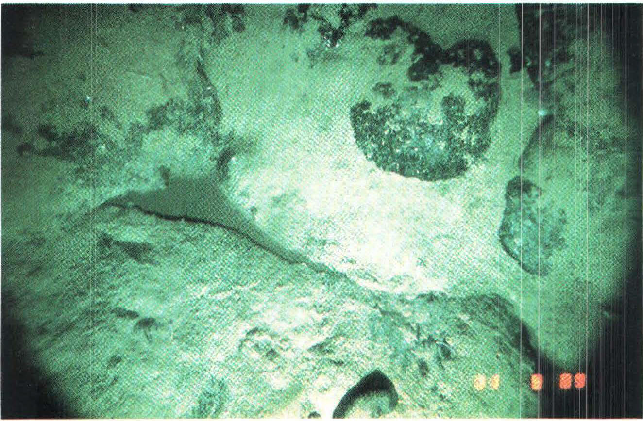


Sources/Usage: Public Domain. View Media Details
Related Content
Learn more about our research project.
Global Marine Mineral Resources
Researching seafloor mineral resources that occur within the U.S. Exclusive Economic Zone and areas beyond national jurisdictions.
Watch short videos from the sea about the expedition.

Escanaba Trough Expedition: Biological Communities
The familiar saying “good things come in small packages” holds especially true for deep-sea biological communities at hydrothermal vents, including those at Escanaba Trough, a seafloor spreading center located almost 200 miles off the northern California coast.

Escanaba Trough Expedition: Gravity Coring
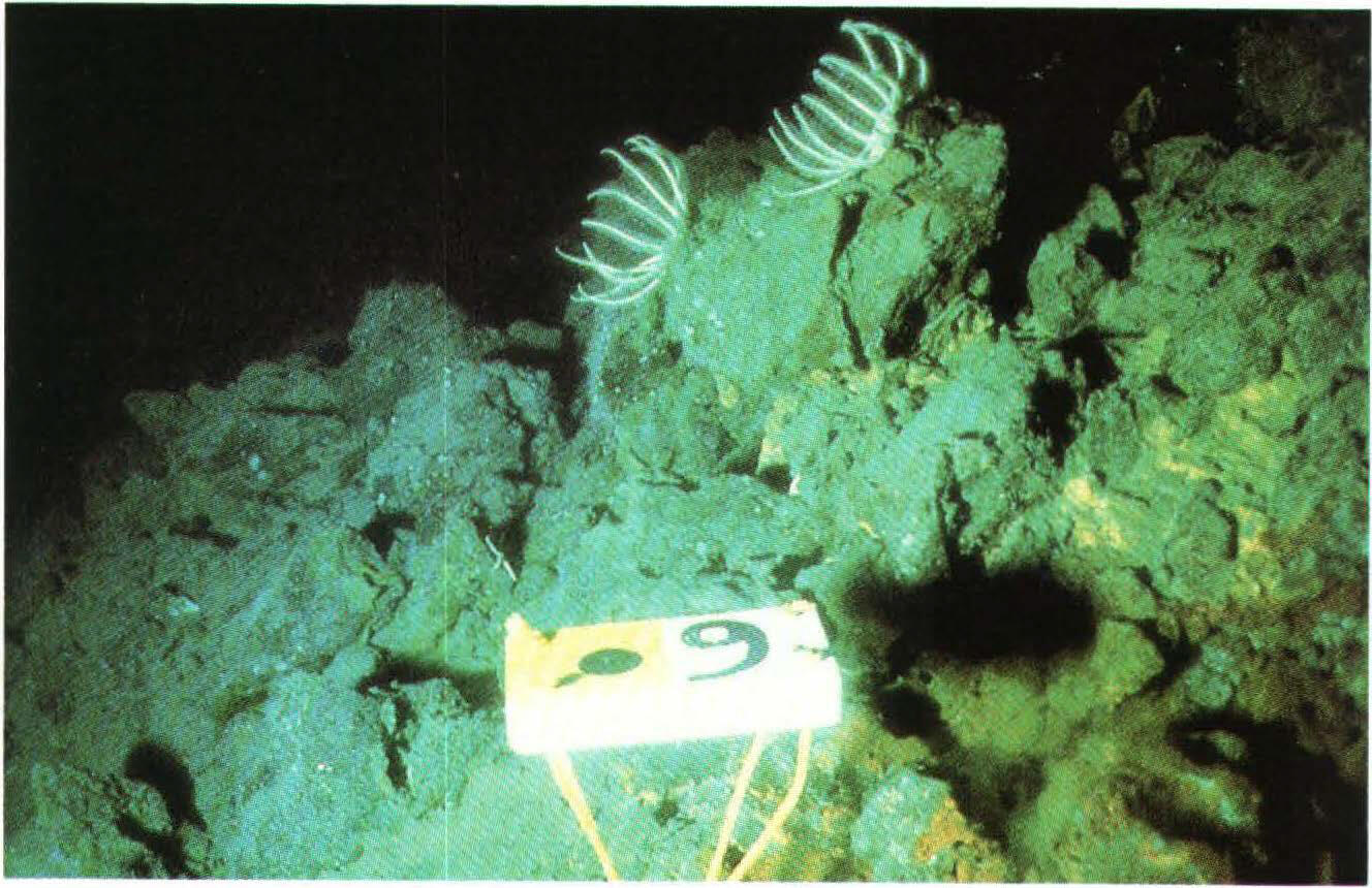
Seafloor features such as sulfide mounds and chimneys are prominent evidence of hydrothermal activity. These features, whether active or dormant, are just the tip of the iceberg, so to speak; much of the “plumbing” of hydrothermal systems exists beneath the seafloor surface.
Seafloor features such as sulfide mounds and chimneys are prominent evidence of hydrothermal activity. These features, whether active or dormant, are just the tip of the iceberg, so to speak; much of the “plumbing” of hydrothermal systems exists beneath the seafloor surface.

Escanaba Trough Expedition: Part 2
Critical to scientific operations aboard the Escanaba Trough expedition is the submersible robots Sentry and Jason. Owned and operated by the Woods Hole Oceanographic Institute (WHOI), these robots allow researchers to observe seafloor features and collect data from depths seldom visited by humans.
Critical to scientific operations aboard the Escanaba Trough expedition is the submersible robots Sentry and Jason. Owned and operated by the Woods Hole Oceanographic Institute (WHOI), these robots allow researchers to observe seafloor features and collect data from depths seldom visited by humans.

Escanaba Trough Expedition: Part 3
For scientists aboard the Escanaba Trough expedition, obtaining sediment cores or deep-sea biological and geological samples after a Jason dive is only the beginning.
For scientists aboard the Escanaba Trough expedition, obtaining sediment cores or deep-sea biological and geological samples after a Jason dive is only the beginning.

Escanaba Trough Expedition: Introduction
Embarking on a three-week deep-sea research expedition requires a lot of preparation. For this expedition to Escanaba Trough, U.S. Geological Survey scientists and partners spend the first few days in port, building their laboratory space aboard the research vessel Thomas G. Thompson.
Embarking on a three-week deep-sea research expedition requires a lot of preparation. For this expedition to Escanaba Trough, U.S. Geological Survey scientists and partners spend the first few days in port, building their laboratory space aboard the research vessel Thomas G. Thompson.
Related Content
Learn more about our research project.
Global Marine Mineral Resources
Researching seafloor mineral resources that occur within the U.S. Exclusive Economic Zone and areas beyond national jurisdictions.
Watch short videos from the sea about the expedition.
Escanaba Trough Expedition: Biological Communities
The familiar saying “good things come in small packages” holds especially true for deep-sea biological communities at hydrothermal vents, including those at Escanaba Trough, a seafloor spreading center located almost 200 miles off the northern California coast.
The familiar saying “good things come in small packages” holds especially true for deep-sea biological communities at hydrothermal vents, including those at Escanaba Trough, a seafloor spreading center located almost 200 miles off the northern California coast.
Escanaba Trough Expedition: Gravity Coring
Seafloor features such as sulfide mounds and chimneys are prominent evidence of hydrothermal activity. These features, whether active or dormant, are just the tip of the iceberg, so to speak; much of the “plumbing” of hydrothermal systems exists beneath the seafloor surface.
Seafloor features such as sulfide mounds and chimneys are prominent evidence of hydrothermal activity. These features, whether active or dormant, are just the tip of the iceberg, so to speak; much of the “plumbing” of hydrothermal systems exists beneath the seafloor surface.
Escanaba Trough Expedition: Part 2
Critical to scientific operations aboard the Escanaba Trough expedition is the submersible robots Sentry and Jason. Owned and operated by the Woods Hole Oceanographic Institute (WHOI), these robots allow researchers to observe seafloor features and collect data from depths seldom visited by humans.
Critical to scientific operations aboard the Escanaba Trough expedition is the submersible robots Sentry and Jason. Owned and operated by the Woods Hole Oceanographic Institute (WHOI), these robots allow researchers to observe seafloor features and collect data from depths seldom visited by humans.
Escanaba Trough Expedition: Part 3
For scientists aboard the Escanaba Trough expedition, obtaining sediment cores or deep-sea biological and geological samples after a Jason dive is only the beginning.
For scientists aboard the Escanaba Trough expedition, obtaining sediment cores or deep-sea biological and geological samples after a Jason dive is only the beginning.
Escanaba Trough Expedition: Introduction
Embarking on a three-week deep-sea research expedition requires a lot of preparation. For this expedition to Escanaba Trough, U.S. Geological Survey scientists and partners spend the first few days in port, building their laboratory space aboard the research vessel Thomas G. Thompson.
Embarking on a three-week deep-sea research expedition requires a lot of preparation. For this expedition to Escanaba Trough, U.S. Geological Survey scientists and partners spend the first few days in port, building their laboratory space aboard the research vessel Thomas G. Thompson.
Get Our News
These items are in the RSS feed format (Really Simple Syndication) based on categories such as topics, locations, and more. You can install and RSS reader browser extension, software, or use a third-party service to receive immediate news updates depending on the feed that you have added. If you click the feed links below, they may look strange because they are simply XML code. An RSS reader can easily read this code and push out a notification to you when something new is posted to our site.