


Large-scale poster describing USGS work.
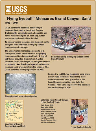
USGS scientists needed a better way to measure river sand in the Grand Canyon. Traditionally, scientists used a bucket to get about 75 sand samples on each trip, which were analyzed weeks later in a lab.

Official websites use .gov
A .gov website belongs to an official government organization in the United States.
Secure .gov websites use HTTPS
A lock () or https:// means you’ve safely connected to the .gov website. Share sensitive information only on official, secure websites.
The USGS Pacific Coastal and Marine Science Center created posters about each of these completed research projects. Here, the posters are presented along with additional information.


Below are science posters available from the USGS Pacific Coastal and Marine Science Center, which highlight a few of our completed studies.
Below are multimedia items associated with this project.

Large-scale poster describing USGS work.
USGS scientists needed a better way to measure river sand in the Grand Canyon. Traditionally, scientists used a bucket to get about 75 sand samples on each trip, which were analyzed weeks later in a lab.
Large-scale poster describing USGS work.
USGS scientists needed a better way to measure river sand in the Grand Canyon. Traditionally, scientists used a bucket to get about 75 sand samples on each trip, which were analyzed weeks later in a lab.

Large-scale poster describing USGS work.
Large-scale poster describing USGS work.

Large-scale poster describing USGS work.
The USGS, in cooperation with the Upper Yuba River Studies Program and the California Bay–Delta Authority (CALFED), studied Englebright Lake. Englebright Dam was built in 1941 to trap sediment washed downstream by hydraulic gold mining.
Large-scale poster describing USGS work.
The USGS, in cooperation with the Upper Yuba River Studies Program and the California Bay–Delta Authority (CALFED), studied Englebright Lake. Englebright Dam was built in 1941 to trap sediment washed downstream by hydraulic gold mining.

Large-scale poster describing USGS work.
Large-scale poster describing USGS work.

Large-scale poster describing USGS work.
The USGS, in cooperation with Moss Landing Marine Laboratory, mapped the slopes of the Santa Barbara Channel using sonar. We combined this with deep sea drilling records and seismic records to make these maps.
Large-scale poster describing USGS work.
The USGS, in cooperation with Moss Landing Marine Laboratory, mapped the slopes of the Santa Barbara Channel using sonar. We combined this with deep sea drilling records and seismic records to make these maps.

Large-scale poster describing USGS work.
The USGS studied air photos of the Big Sur coast taken in 1942 and 1994, in cooperation with the California Department of Transportation (Caltrans) and the University of California at Santa Cruz (UCSC).
Large-scale poster describing USGS work.
The USGS studied air photos of the Big Sur coast taken in 1942 and 1994, in cooperation with the California Department of Transportation (Caltrans) and the University of California at Santa Cruz (UCSC).

Large-scale poster describing USGS work.
Large-scale poster describing USGS work.

Large-scale poster describing USGS work.
The USGS mapped Crater Lake, Oregon using sonar, in cooperation with the National Park Service, the University of New Hampshire, and C&C Technologies.
Large-scale poster describing USGS work.
The USGS mapped Crater Lake, Oregon using sonar, in cooperation with the National Park Service, the University of New Hampshire, and C&C Technologies.

Large-scale poster describing USGS work.
The USGS mapped western San Francisco Bay using sonar, in cooperation with the National Oceanic and Atmospheric Administration (NOAA) and C&C Technologies. Some parts of the Bay floor are so shallow that a large tanker or container ship could run aground at low tide and create a massive oil spill.

Large-scale poster describing USGS work.
The USGS, in cooperation with the UK Institute of Oceanographic Sciences (IOS) and others, took images of the seafloor 200 miles around the Hawaiian Islands using GLORIA. GLORIA is a long-range sonar that gives a bird’s-eye view of the seafloor.
Large-scale poster describing USGS work.
The USGS, in cooperation with the UK Institute of Oceanographic Sciences (IOS) and others, took images of the seafloor 200 miles around the Hawaiian Islands using GLORIA. GLORIA is a long-range sonar that gives a bird’s-eye view of the seafloor.
Below are science posters available from the USGS Pacific Coastal and Marine Science Center, which highlight a few of our completed studies.
Below are multimedia items associated with this project.
Large-scale poster describing USGS work.
USGS scientists needed a better way to measure river sand in the Grand Canyon. Traditionally, scientists used a bucket to get about 75 sand samples on each trip, which were analyzed weeks later in a lab.
Large-scale poster describing USGS work.
USGS scientists needed a better way to measure river sand in the Grand Canyon. Traditionally, scientists used a bucket to get about 75 sand samples on each trip, which were analyzed weeks later in a lab.
Large-scale poster describing USGS work.
Large-scale poster describing USGS work.
Large-scale poster describing USGS work.
The USGS, in cooperation with the Upper Yuba River Studies Program and the California Bay–Delta Authority (CALFED), studied Englebright Lake. Englebright Dam was built in 1941 to trap sediment washed downstream by hydraulic gold mining.
Large-scale poster describing USGS work.
The USGS, in cooperation with the Upper Yuba River Studies Program and the California Bay–Delta Authority (CALFED), studied Englebright Lake. Englebright Dam was built in 1941 to trap sediment washed downstream by hydraulic gold mining.
Large-scale poster describing USGS work.
Large-scale poster describing USGS work.
Large-scale poster describing USGS work.
The USGS, in cooperation with Moss Landing Marine Laboratory, mapped the slopes of the Santa Barbara Channel using sonar. We combined this with deep sea drilling records and seismic records to make these maps.
Large-scale poster describing USGS work.
The USGS, in cooperation with Moss Landing Marine Laboratory, mapped the slopes of the Santa Barbara Channel using sonar. We combined this with deep sea drilling records and seismic records to make these maps.
Large-scale poster describing USGS work.
The USGS studied air photos of the Big Sur coast taken in 1942 and 1994, in cooperation with the California Department of Transportation (Caltrans) and the University of California at Santa Cruz (UCSC).
Large-scale poster describing USGS work.
The USGS studied air photos of the Big Sur coast taken in 1942 and 1994, in cooperation with the California Department of Transportation (Caltrans) and the University of California at Santa Cruz (UCSC).
Large-scale poster describing USGS work.
Large-scale poster describing USGS work.
Large-scale poster describing USGS work.
The USGS mapped Crater Lake, Oregon using sonar, in cooperation with the National Park Service, the University of New Hampshire, and C&C Technologies.
Large-scale poster describing USGS work.
The USGS mapped Crater Lake, Oregon using sonar, in cooperation with the National Park Service, the University of New Hampshire, and C&C Technologies.
Large-scale poster describing USGS work.
The USGS mapped western San Francisco Bay using sonar, in cooperation with the National Oceanic and Atmospheric Administration (NOAA) and C&C Technologies. Some parts of the Bay floor are so shallow that a large tanker or container ship could run aground at low tide and create a massive oil spill.
Large-scale poster describing USGS work.
The USGS, in cooperation with the UK Institute of Oceanographic Sciences (IOS) and others, took images of the seafloor 200 miles around the Hawaiian Islands using GLORIA. GLORIA is a long-range sonar that gives a bird’s-eye view of the seafloor.
Large-scale poster describing USGS work.
The USGS, in cooperation with the UK Institute of Oceanographic Sciences (IOS) and others, took images of the seafloor 200 miles around the Hawaiian Islands using GLORIA. GLORIA is a long-range sonar that gives a bird’s-eye view of the seafloor.