
Subsidence Science in Oklahoma and Texas - Overview Active
The USGS Oklahoma-Texas Water Science Center (OTWSC) has researched land-surface subsidence for more than 40 years. OTWSC collects and interprets groundwater level and aquifer sediment compaction data to understand the effects of groundwater withdrawal on land surface subsidence.
SUBSIDENCE SCIENCE CAPABILITIES
OTWSC has expertise in subsidence science applications, including, but not limited to:
- Modeling of land subsidence
- Routine measuring of water levels in a large well network (more than 700 wells)
- Developing regional depictions of groundwater levels
- Incorporating groundwater-level data into geographic information system (GIS) to construct regional water-level altitude and water-level change contour maps.
- Mapping applications that allow users to view annual water-level altitudes, water-level changes over time, and historical time series of compaction data.
Find out more about OTWSC groundwater science expertise in this printable information sheet.

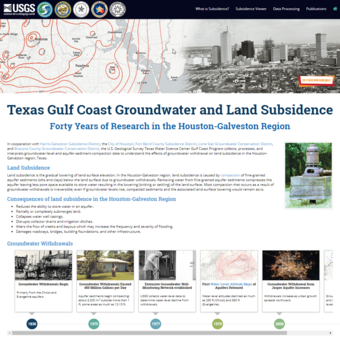
Texas Gulf Coast Groundwater and Land Subsidence Web Application
This USGS viewer shows how water levels have changed over time and how groundwater demands have affected land subsidence in the region. Scientists created this tool using the largest subsidence data set in the US with more than 40 years of groundwater and compaction observations.
CURRENT SUBSIDENCE SCIENCE
Projects related to Subsidence Science are listed below.

Houston Area Groundwater Level and Subsidence Monitoring
- Overview
The USGS Oklahoma-Texas Water Science Center (OTWSC) has researched land-surface subsidence for more than 40 years. OTWSC collects and interprets groundwater level and aquifer sediment compaction data to understand the effects of groundwater withdrawal on land surface subsidence.
SUBSIDENCE SCIENCE CAPABILITIES
OTWSC has expertise in subsidence science applications, including, but not limited to:
- Modeling of land subsidence
- Routine measuring of water levels in a large well network (more than 700 wells)
- Developing regional depictions of groundwater levels
- Incorporating groundwater-level data into geographic information system (GIS) to construct regional water-level altitude and water-level change contour maps.
- Mapping applications that allow users to view annual water-level altitudes, water-level changes over time, and historical time series of compaction data.
Find out more about OTWSC groundwater science expertise in this printable information sheet.
Sources/Usage: Public Domain. View Media Details
Sources/Usage: Public Domain. View Media DetailsTexas Gulf Coast Groundwater and Land Subsidence Web Application
This USGS viewer shows how water levels have changed over time and how groundwater demands have affected land subsidence in the region. Scientists created this tool using the largest subsidence data set in the US with more than 40 years of groundwater and compaction observations.
Sources/Usage: Public Domain. View Media DetailsCURRENT SUBSIDENCE SCIENCE
- Science
Projects related to Subsidence Science are listed below.
Houston Area Groundwater Level and Subsidence Monitoring
In cooperation with Harris-Galveston Subsidence District, the City of Houston, Fort Bend County Subsidence District, Lone Star Groundwater Conservation District, and Brazoria County Groundwater Conservation District, the USGS Oklahoma-Texas Water Science Center Gulf Coast Program collects, processes, and interprets groundwater-level and aquifer-sediment-compaction data to understand the effects of... - Publications