
Volcano Science Center
Find U.S. Volcano
The Volcano Science Center is the primary center serving the mission of the USGS Volcano Hazards Program — to enhance public safety and minimize social and economic disruption from volcanic unrest and eruption. The center is home to the five US volcano observatories with offices in Anchorage, Alaska; Menlo Park and Mountain View, California; Vancouver, Washington; and Hilo, Hawaii.


News
Photo & Video Chronology — February 16, 2026 — Kīlauea episode 42 fountains and fallout
Photo & Video Chronology — February 16, 2026 — Kīlauea episode 42 fountains and fallout
A brief history of volcanology: from myths and legends to a modern and interdisciplinary science
A brief history of volcanology: from myths and legends to a modern and interdisciplinary science
Be my Valentine (Geyser)
Be my Valentine (Geyser)
Publications
A comparison of non-contact methods for measuring turbidity in the Colorado River A comparison of non-contact methods for measuring turbidity in the Colorado River
Monitoring suspended-sediment concentration (SSC) is essential to better understand how sediment transport could adversely affect water availability for human communities and ecosystems. Aquatic remote sensing methods are increasingly utilized to estimate SSC and turbidity in rivers; however, an evaluation of their quantitative performance is limited. This study evaluates the performance...
Toward a four-dimensional petrogenetic model of a distributed volcanic field on the southern edge of the Colorado Plateau Toward a four-dimensional petrogenetic model of a distributed volcanic field on the southern edge of the Colorado Plateau
A detailed characterization of the >3,000 square kilometer (km2) Springerville volcanic field, located on the southern tip of the Colorado Plateau in Arizona, United States, with its more than 501 volcanic units and widely distributed >420 cinder cones and lava flows, provides constraints toward an integrated petrogenetic model for the field. Large-volume effusive tholeiitic eruptions at...
Luminescence dating of hydrothermal explosions in the Yellowstone Plateau volcanic field Luminescence dating of hydrothermal explosions in the Yellowstone Plateau volcanic field
Hydrothermal explosions are a significant geological hazard in some active volcanic systems; however, the timing and triggering mechanisms of these explosions are poorly constrained. This study applies luminescence dating techniques to hydrothermal explosion deposits in the Yellowstone Plateau volcanic field to constrain explosion chronologies and evaluate potential triggering mechanisms...
Science
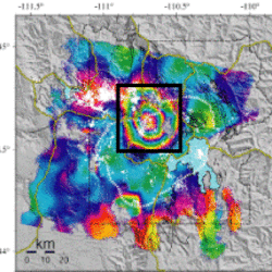
Uplift along the north rim of Yellowstone Caldera
An area on the north rim of Yellowstone caldera, to the south of Norris Geyser Basin, started to uplift slightly in July 2025. Similar deformation occurred in the same area during 1996-2004 and reveals characteristics of the subsurface.
USGS volcano-hydrothermal fluid chemistry data
The USGS has published chemistry data for volcanic and hydrothermal fluids sampled at sites around the United States.

How are lava flows mapped in Hawaii?
Lava flow mapping provides situational awareness of volcanic eruptive hazards in Hawaii. During eruptions, USGS Hawaiian Volcano Observatory (HVO) scientists employ a variety of techniques to collect and disseminate map data depicting key eruptive features, especially lava flows.