
Natural Hazards
How do volcanoes erupt?
Can you predict earthquakes?
What is the difference between a tsunami and a tidal wave?
What is a landslide and what causes one?
The USGS monitors and conducts research on a wide range of natural hazards to help decision-makers prepare for and respond to hazard events that threaten life and property.

Can I get on a list to receive an email message when there is an earthquake? How do I sign up for earthquake notifications? Are there any Feeds I can subscribe to?
Please go to the USGS Earthquake Notification Services (ENS) to sign up for free emails or text messages to your phone. Use the default settings or customize ENS to fit your needs. Also check out the many different Earthquake Feeds . ENS is NOT an earthquake early warning system. Messages issued by ENS will almost always arrive after you would feel any shaking. Learn more: How do I sign up for...

Why do some earthquakes disappear from the map/list?
The USGS and networks contributing to the Advance National Seismic System (ANSS) take great effort to provide accurate and timely earthquake information. Occasionally our systems produce erroneous information that is released to the public via our web pages or Earthquake Notification System . These mistakes are generally promptly identified by seismologists, removed from our web pages, and “delete...

Why isn't the fault on which the earthquake occurred or the distance to the nearest fault provided?
Seismologists evaluate the hypocenter location and the focal mechanism of an earthquake to decide if the earthquake occurs on a named fault. Research shows that many earthquakes occur on small, un-named faults located near well-known faults. For example, most of the aftershocks of the 1989 M6.9 Loma Prieta earthquake occurred on small, subsidiary faults within a few hundred meters of the mainshock...

Did I feel an earthquake? Can I report feeling an earthquake?
Report an earthquake experience or related observation through the Did You Feel It? citizen science webpage. The best way to do this is to click on the earthquake that you think you felt on one of the lists on the Earthquakes webpage, and then select the "Tell Us!" link. If you don't see the earthquake you think you felt, use the green "Report an Unknown Event" button on our Did You Feel It? page...

Why is the earthquake that was reported/recorded by network X, or that I felt, not on the Latest Earthquakes map/list?
The USGS Latest Earthquakes map and lists show events that have been located by the USGS and contributing agencies within the last 30 days. They should NOT be considered complete lists of all events in the U.S. and adjacent areas and especially should NOT be considered complete lists of all magnitude 4.5 and greater events that occur around the globe. In most cases, we locate and report an...
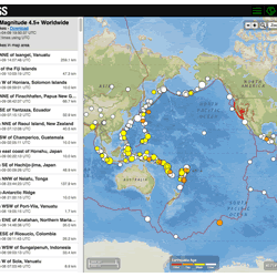
Where can I find current earthquake lists and maps for the world or for a specific area?
The Earthquake Hazards Program Latest Earthquakes Map displays earthquakes in near-realtime and up to the past 30 days of earthquakes. The interface includes three panels: a list of earthquakes, a map, and a settings/options panel. You can pan and zoom the map to view specific areas. Click on an event on the list or map for additional information and a link to the event page with all the details...

What is the difference between a landslide advisory, a landslide watch, and a landslide warning?
An advisory is a general statement about the potential of landslide activity in a given region relative to developing rainfall predictions. An advisory may include general statements about rainfall conditions that can lead to debris-flow activity, and list precautions to be taken in the event of heavy rainfall. A watch means that landslide-activity will be possible, but is not imminent. People in...

How many deaths result from landslides each year?
An average of 25-50 people are killed by landslides each year in the United States. The worldwide death toll per year due to landslides is in the thousands. Most landslide fatalities are from rock falls, debris flows, or volcanic debris flows (called lahars). Twenty-three people were killed, at least 167 injured, and more than 400 homes were damaged by a series of debris flows that impacted the...

Do human activities cause landslides?
Yes, in some cases human activities can be a contributing factor in causing landslides. Many human-caused landslides can be avoided or mitigated. They are commonly a result of building roads and structures without adequate grading of slopes, poorly planned alteration of drainage patterns, and disturbing old landslides. Detailed on-site investigation is required to determine the importance of human...

Does vog (volcanic smog) impact plants and animals?
The sulfuric acid droplets in vog have the corrosive properties of dilute battery acid. When vog mixes directly with moisture on the leaves of plants it can cause severe chemical burns, which can damage or kill the plants. Sulfur dioxide (SO 2 ) gas can also diffuse through leaves and dissolve to form acidic conditions within plant tissue. Farmers on Hawai`i Island, particularly in the Ka`u...

What gases are emitted by Kīlauea and other active volcanoes?
Ninety-nine percent of the gas molecules emitted during a volcanic eruption are water vapor (H 2 O), carbon dioxide (CO 2 ), and sulfur dioxide (SO 2 ). The remaining one percent is comprised of small amounts of hydrogen sulfide, carbon monoxide, hydrogen chloride, hydrogen fluoride, and other minor gas species. Learn more: Volcanic gases can be harmful to health, vegetation and infrastructure

Who monitors volcanic gases emitted by Kīlauea and how is it done?
The U.S. Geological Survey's Hawaiian Volcano Observatory (HVO) determines the amount and composition of gases emitted by Kīlauea Volcano. Changes in gas emissions can reveal important clues about the inner workings of a volcano, so they are measured on a regular basis. HVO scientists use both remote and direct sampling techniques to measure compositions and emission rates of gas from Kīlauea...