
Landsat Provides Near Real-Time Global Agricultural Analysis
Dr. Stephanie Hulina, President of Geospatial Data Analysis Corporation (GDA Corp) discusses how access to free Landsat imagery from USGS provides value-added products to her company’s clients.
Return to Landsat In Action Overview
Despite being a small business, Geospatial Data Analysis Corporation (GDA Corp.) is a major commercial user of Landsat imagery. Dr. Hulina notes, “The long-term continuity of the Landsat mission is essential to GDA’s ability to maintain a competitive edge in today’s global economy. The imagery has helped GDA to serve its clients, especially in the agricultural arena, some of whom were previously unaware of the tremendous value that satellite imagery and its analysis can bring to their decision-making and ultimately to their company’s bottom line. GDA agricultural analysis would not be possible without free, reliable, and high quality Landsat data offered by USGS.”
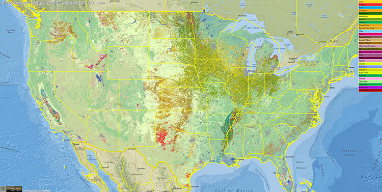
A significant part of GDA’s daily business relies on processing and analyzing large amounts of Landsat imagery from around the world. Landsat’s combination of moderate spatial resolution (60-meters and 30-meters), multispectral and thermal bands, and its long historical record all provide an ideal database for crop mapping, monitoring, assessments, and forecasting. GDA maintains an operational end-to-end automated system for continuous download, surface reflectance calibration, and mosaicking of terabytes of surface reflectance calibrated Landsat imagery. GDA calibration and mosaicking of the imagery occurs within a few hours of data acquisition and scene availability by the U.S. Geological Survey (USGS) Earth Resources Observation and Science (EROS) Center. GDA generates bi-monthly time series imagery mosaics covering all major agricultural areas of the world. For each mosaic, GDA tracks per pixel data quality, sourced sensor, and date; this information enables near real-time mosaic updates as soon as new imagery becomes available from the USGS.

GDA depends on its analysis-ready time series of surface reflectance calibrated Landsat mosaics for its global crop analysis. The mosaics offer a tremendous value by enabling regional time series analysis, supporting field-to-country assessments, and reducing more than 80 percent of the imagery data volume. GDA’s current season crop assessments rely on the relationships between time series spectral properties and crop types established for the past 10-15 years. These relationships facilitate highly automated in-season field level crop mapping, which is the foundation for regional crop monitoring, frequent crop area and condition assessments, and estimations of end-of-season yields and production. The crop mapping is performed continuously and the results are updated bi-monthly.


GDA’s client interests range from detection of data gaps in the imagery, image calibration to surface reflectance, and image mosaicking to enhanced image analysis techniques to answer questions such as when, where, and how much of a particular crop is planted, and what is the expected yield of that crop. GDA has a long-standing working relationship with the Foreign Agricultural Service (FAS) of the U.S. Department of Agriculture (USDA). Working with the Office of Global Analysis/International Production Assessment Division within FAS, GDA has used its technology alongside the expertise of the USDA/FAS to provide timely and accurate global crop intelligence while consistently covering all major agricultural regions annually. GDA analysis of Landsat imagery and the final products generated from it factor into the global agricultural production forecasts that FAS releases every month. The national importance of FAS activities is illustrated by the inclusion of its “World Agricultural Supply and Demand Estimates and World Agricultural Production (WASDE)” USDA publication in the Office of Management and Budget’s (OMB) Principal Federal Economic Indicators for the White House.
Visit the GDA Corp. website for more information: http://www.gdacorp.com.
February 2017