
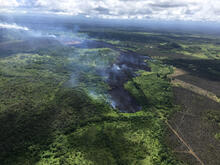
At 3:24 p.m. , the flow front of Fissure 17 continues down slope. ...

Detailed Description
At 3:24 p.m. HST, the flow front of Fissure 17 continues down slope. The barren, brown area to the right in the photograph is a lobe of the Kii Flow from the eruption of 1955. The Fissure 17 flow front is located approximately .7 miles makai of Highway 132 and is 1.3 miles mauka of Hwy 137.