
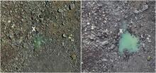
Halema‘uma‘u taken during a helicopter lidar survey on July 25, 2019

Detailed Description
Telephoto views of water in the bottom of Halema‘uma‘u taken during a helicopter lidar survey on July 25, 2019 (left), when the pond was first observed, and a USGS overflight on August 1, 2019 (right). The pond grew slightly in size and depth between the two dates; an "X" marks the same rock in both photos for comparison. Left photo courtesy of Ron Chapelle, Quantum Spatial. USGS photo (right) by S. Conway.
Sources/Usage
Public Domain.