
Kīlauea caldera gas mapping—August 10, 2021

Detailed Description
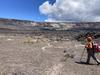
During the gas survey of Kīlauea caldera, HVO scientists walk transects in a grid-like pattern. As they traverse, the MultiGAS instruments that they are carrying on their backs measure the amount of carbon dioxide (CO2), sulfur dioxide (SO2), water vapor (H2O), and hydrogen sulfide (H2S). The measurements will be used to create a map showing the areas of the caldera floor where specific volcanic gasses are being emitted and their concentrations. USGS photo by K. Mulliken on August 10, 2021.
Sources/Usage
Public Domain.