
Kīlauea caldera gas mapping - July 28, 2021 — Kīlauea

Detailed Description
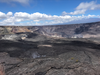
While mapping volcanic gasses in Kīlauea caldera, HVO scientists got a view (looking west) of Halema‘uma‘u and the down-dropped block. The steep crater walls of Halema‘uma‘u are visible in the upper center and right portions of this photo, but the recently active lava lake is out of view below the eastern crater rim. The down-dropped block—in the center of the photo—was at the same height as the caldera floor in the foreground prior to subsiding more than 100 m (330 ft) in some places during the 2018 collapse events. South sulfur bank, the light-colored walls on the left side of the image, were also exposed during the 2018 collapses. The southeast flank of Mauna Loa is visible in the upper right. USGS photo taken by L. DeSmither on July 28, 2021.
Sources/Usage
Public Domain.