
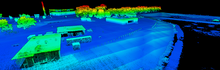
LiDAR point cloud from Yellowscan VX20 of Downing Reservoir on the DFC

Detailed Description
UAS LiDAR point cloud from the Yellowscan VX20 (Riegl miniVUX-1 UAV) scanner of the Downing Reservoir located at the Denver Federal Center, CO. The blue-green-yellow-red color ramp represents height-above-ground measured distances. The building structures within the scan validate the measured point cloud lidar distances with known true distances taken in the field.
Sources/Usage
Public Domain.