
Map of June 27th flow in Kīlauea's ERZ

Detailed Description
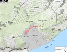
Map showing the June 27th flow in Kīlauea's East Rift Zone as of August 27, 2014. The area of the flow as mapped on August 25 is shown in pink, while widening and advancement of the flow as of August 27 is shown in red. The brown line marks the ground crack that channeled lava to the east, where it emerged to form a new pad of lava over the past couple of days. The distal tip of this new lava pad is 11.5 km (7.1 miles) east-northeast of Pu‘u ‘Ō‘ō, and 3.0 km (1.9 miles) from the edge of the Wao Kele O Puna Forest Reserve. However, the tip of the flow was inactive today and there was no indication that lava was continuing to advance within ground cracks. The most distant active flows were 8.5 km (5.3 miles) from the vent. All older lava flows (1983-2014) are shown in gray. The thin yellow line marks a portion of the lava tube feeding the flow.
Sources/Usage
Public Domain.