
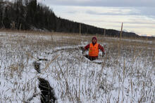
A USGS geologist stands in a crack in tide flat sediment, Alaska

Detailed Description
A USGS scientist stands in a crack in tide flat sediment that opened during strong shaking in the November 30, 2018 Anchorage earthquake. This upland ground crack near Cottonwood Creek, Palmer Slough had horizontal displacements of ~2.5ft locally and observed maximum depth of ~3ft. The crack was observed ~150ft from the active river channel. This was one of 153 ground failure features mapped and inventoried by USGS scientists in the weeks following the earthquake. Ground failure inventories like this are essential for understanding earthquake hazard to regional infrastructure and improve regional maps of earthquake-triggered landslide susceptibility.
Sources/Usage
Public Domain.