Infographic on USGS critical mineral supply chain analysis.
Minerals are essential to power homes and businesses and to manufacture products and technologies, from phones to vehicles.

Official websites use .gov
A .gov website belongs to an official government organization in the United States.
Secure .gov websites use HTTPS
A lock () or https:// means you’ve safely connected to the .gov website. Share sensitive information only on official, secure websites.

Infographic on USGS critical mineral supply chain analysis.
Minerals are essential to power homes and businesses and to manufacture products and technologies, from phones to vehicles.
Infographic on USGS critical mineral supply chain analysis.
Minerals are essential to power homes and businesses and to manufacture products and technologies, from phones to vehicles.

USGS National Innovation Center UAS Research Center Saucer Shark Project, before science flight tests, Aeroshell and payload. Sling configuration and payload orientation verified before science flight deployment. Payload is on and ready to record!
USGS National Innovation Center UAS Research Center Saucer Shark Project, before science flight tests, Aeroshell and payload. Sling configuration and payload orientation verified before science flight deployment. Payload is on and ready to record!

USGS National Innovation Center UAS Research Center Saucer Shark Project, BisonCore displays the path of the sensor live, as it covers transects. Data received from the payload is then displayed within the BisonCore Ecosystem and is accessible for field viewing. The magnetic map is also used to validate payload directed algorithms.
USGS National Innovation Center UAS Research Center Saucer Shark Project, BisonCore displays the path of the sensor live, as it covers transects. Data received from the payload is then displayed within the BisonCore Ecosystem and is accessible for field viewing. The magnetic map is also used to validate payload directed algorithms.

USGS National Innovation Center UAS Research Center Saucer Shark Project, during flight tests, drop release attached to USGS UAV. Aircraft sits on landing pad in-between test flights.
USGS National Innovation Center UAS Research Center Saucer Shark Project, during flight tests, drop release attached to USGS UAV. Aircraft sits on landing pad in-between test flights.
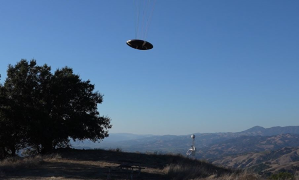
USGS National Innovation Center UAS Research Center Saucer Shark Project, during flight tests, aeroshell. Saucer Shark on landing approach after completed mission. Just above the landing pad.
USGS National Innovation Center UAS Research Center Saucer Shark Project, during flight tests, aeroshell. Saucer Shark on landing approach after completed mission. Just above the landing pad.

USGS National Innovation Center UAS Research Center (UASRC) Saucer Shark Project, during flight tests, fully assembled. Sub assemblies from top down: Drop Release, Sling and Sling Brace, Payload Aeroshell and Payload.
USGS National Innovation Center UAS Research Center (UASRC) Saucer Shark Project, during flight tests, fully assembled. Sub assemblies from top down: Drop Release, Sling and Sling Brace, Payload Aeroshell and Payload.
")
The familiar saying “good things come in small packages” holds especially true for deep-sea biological communities at hydrothermal vents, including those at Escanaba Trough, a seafloor spreading center located almost 200 miles off the northern California coast.
The familiar saying “good things come in small packages” holds especially true for deep-sea biological communities at hydrothermal vents, including those at Escanaba Trough, a seafloor spreading center located almost 200 miles off the northern California coast.
The familiar saying “good things come in small packages” holds especially true for deep-sea biological communities at hydrothermal vents, including those at Escanaba Trough, a seafloor spreading center located almost 200 miles off the northern California coast.
The familiar saying “good things come in small packages” holds especially true for deep-sea biological communities at hydrothermal vents, including those at Escanaba Trough, a seafloor spreading center located almost 200 miles off the northern California coast.

Join USGS researchers Jason Chaytor and Kira Mizell as they virtually participate in a NOAA Ocean Exploration expedition to the depths of the North Atlantic.
Join USGS researchers Jason Chaytor and Kira Mizell as they virtually participate in a NOAA Ocean Exploration expedition to the depths of the North Atlantic.

A 2020 year in review of the many accomplishments of the US Geological Survey. A year that began with seismic activity in Southwest Puerto Rico, to the first-ever public testing of USGS ShakeAlerts, USGS scientists and technicians helped to track storm data during the 2020 Atlantic Hurricane season.
A 2020 year in review of the many accomplishments of the US Geological Survey. A year that began with seismic activity in Southwest Puerto Rico, to the first-ever public testing of USGS ShakeAlerts, USGS scientists and technicians helped to track storm data during the 2020 Atlantic Hurricane season.

As part of Earth Science Week 2020, USGS scientist Shannon Mahan takes us on a tour of quartz and how geologists like her use quartz to study all kinds of things, from earthquakes to archaeology.
As part of Earth Science Week 2020, USGS scientist Shannon Mahan takes us on a tour of quartz and how geologists like her use quartz to study all kinds of things, from earthquakes to archaeology.
")
The USGS Florence Bascom Geoscience Center (FBGC) is at the leading edge of scientific research addressing critical societal issues and providing unbiased data and information to decision makers and the public.
The USGS Florence Bascom Geoscience Center (FBGC) is at the leading edge of scientific research addressing critical societal issues and providing unbiased data and information to decision makers and the public.