地震发生区域
国家地震灾害模型,2023 年
纽约市的地震
您知道自己生活在“地震带”吗?这是真 的。纽约市等地过去曾发生过地震,将来 还会发生。如果您感到地面在震动,请确 保知道怎么做:趴下、掩护和稳住!
如果您感觉到地面在震动
趴下 掩护 稳住
规模最大的地震 - 纽约市 - 1884年8月10日 - 震级 5.2

An official website of the United States government
Here's how you know
Official websites use .gov
A .gov website belongs to an official government organization in the United States.
Secure .gov websites use HTTPS
A lock () or https:// means you’ve safely connected to the .gov website. Share sensitive information only on official, secure websites.
地震发生区域
国家地震灾害模型,2023 年
纽约市的地震
您知道自己生活在“地震带”吗?这是真 的。纽约市等地过去曾发生过地震,将来 还会发生。如果您感到地面在震动,请确 保知道怎么做:趴下、掩护和稳住!
如果您感觉到地面在震动
趴下 掩护 稳住
规模最大的地震 - 纽约市 - 1884年8月10日 - 震级 5.2
地震发生区域
国家地震灾害模型,2023 年
纽约市的地震
您知道自己生活在“地震带”吗?这是真 的。纽约市等地过去曾发生过地震,将来 还会发生。如果您感到地面在震动,请确 保知道怎么做:趴下、掩护和稳住!
如果您感觉到地面在震动
趴下 掩护 稳住
规模最大的地震 - 纽约市 - 1884年8月10日 - 震级 5.2

CÁC TRẬN ĐỘNG ĐẤT XẢY RA Ở ĐÂU
Theo Mô Hình Cảnh Báo Nguy Hiểm Động Đất Toàn Quốc, 2023
ĐỘNG ĐẤT TẠI THÀNH PHỐ NEW YORK
CÁC TRẬN ĐỘNG ĐẤT XẢY RA Ở ĐÂU
Theo Mô Hình Cảnh Báo Nguy Hiểm Động Đất Toàn Quốc, 2023
ĐỘNG ĐẤT TẠI THÀNH PHỐ NEW YORK

ГДЕ БЫВАЮТ ЗЕМЛЕТРЯСЕНИЯ
Общенациональная модель сейсмической опасности 2023 г.
ЗЕМЛЕТРЯСЕНИЯ В НЬЮ-ЙОРКЕ
ГДЕ БЫВАЮТ ЗЕМЛЕТРЯСЕНИЯ
Общенациональная модель сейсмической опасности 2023 г.
ЗЕМЛЕТРЯСЕНИЯ В НЬЮ-ЙОРКЕ

LÀ OÙ LES SÉISMES SE PRODUISENT
Modèle de l’aléa sismique au niveau national, 2023
LES SÉISMES DANS LA VILLE DE NEW YORK
LÀ OÙ LES SÉISMES SE PRODUISENT
Modèle de l’aléa sismique au niveau national, 2023
LES SÉISMES DANS LA VILLE DE NEW YORK

DÓNDE SE PRODUCEN LOS TERREMOTOS
Modelo Nacional de Riesgo Sísmico, 2023
TERREMOTOS EN LA CIUDAD DE NUEVA YORK
DÓNDE SE PRODUCEN LOS TERREMOTOS
Modelo Nacional de Riesgo Sísmico, 2023
TERREMOTOS EN LA CIUDAD DE NUEVA YORK

KOTE GEN TRANBLEMANNTÈ
(Modèl risk tranblemanntè nan nivo nasyonal, 2023)
TRANBLEMANNTÈ NAN VIL NEW YORK
KOTE GEN TRANBLEMANNTÈ
(Modèl risk tranblemanntè nan nivo nasyonal, 2023)
TRANBLEMANNTÈ NAN VIL NEW YORK
![Earthquake Activity in Turkey and Syria [Press Briefing] thumbnail turkey earthquake press conference](https://d9-wret.s3.us-west-2.amazonaws.com/assets/palladium/production/s3fs-public/styles/masonry/public/media/images/Earthquake%20Activity%20in%20Turkey%20and%20Syria%20%5BPress%20Briefing%5D.jpg?itok=YWGrgQOF) Earthquake Activity in Turkey and Syria [Press Briefing]
Earthquake Activity in Turkey and Syria [Press Briefing]
On February 6, around 4:15 a.m. local time, a magnitude 7.8 earthquake struck south-central Turkey near the Turkey/Syria border.
On February 6, around 4:15 a.m. local time, a magnitude 7.8 earthquake struck south-central Turkey near the Turkey/Syria border.
 Mapping the Ground Failure—Puerto Rico Post-Dec 28, 2019 Quake
My name is Kate Allstadt. I’m a research geophysicist with the U.S.
My name is Kate Allstadt. I’m a research geophysicist with the U.S.
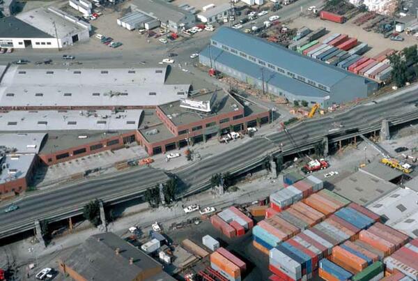
 Initial Observations of Cypress Structure Collapse, Oakland, CA 1989
Retrospective interview with USGS Geophysicist Susan Hough about the collapse of the Nimitz Freeway (known as the Cypress Structure) in Oakland, CA, during the October 17, 1989 Loma Prieta Earthquake and how the first responders reacted to the event.
Retrospective interview with USGS Geophysicist Susan Hough about the collapse of the Nimitz Freeway (known as the Cypress Structure) in Oakland, CA, during the October 17, 1989 Loma Prieta Earthquake and how the first responders reacted to the event.
 Sight Response and Cypress Structure Collapse, Oakland, CA 1989
Retrospective interview with USGS Geophysicist Susan Hough about her early earthquake work during the 1989 Loma Prieta earthquake. The interview covers how the Cypress Structure collapse in Oakland, CA, served as a site response study for seismic research.
Retrospective interview with USGS Geophysicist Susan Hough about her early earthquake work during the 1989 Loma Prieta earthquake. The interview covers how the Cypress Structure collapse in Oakland, CA, served as a site response study for seismic research.
On October 17, 1989, at 5:04 pm a magnitude M6.9 earthquake struck near Loma Prieta, California. It was a tragic reminder of the destructive power of earthquakes. However, it was also a watershed moment in seismic research. 30 years later, we revisit the earthquake through the eyes of the scientists who experienced it. And studied it. These are their stories.
On October 17, 1989, at 5:04 pm a magnitude M6.9 earthquake struck near Loma Prieta, California. It was a tragic reminder of the destructive power of earthquakes. However, it was also a watershed moment in seismic research. 30 years later, we revisit the earthquake through the eyes of the scientists who experienced it. And studied it. These are their stories.
On October 17, 1989, at 5:04 pm a magnitude M6.9 earthquake struck near Loma Prieta, California. It was a tragic reminder of the destructive power of earthquakes. However, it was also a watershed moment in seismic research. 30 years later, we revisit the earthquake through the eyes of the scientists who experienced it. And studied it. These are their stories.
On October 17, 1989, at 5:04 pm a magnitude M6.9 earthquake struck near Loma Prieta, California. It was a tragic reminder of the destructive power of earthquakes. However, it was also a watershed moment in seismic research. 30 years later, we revisit the earthquake through the eyes of the scientists who experienced it. And studied it. These are their stories.


