
EarthView – Wildfires Scorch Large Swaths Along OK-KS border
USGS EarthView of the Week
This week's EarthView is a scorcher!
EarthViews is a continuing series in which we share a USGS Image of the Week featuring the USGS/NASA Landsat program. From the artistry of Earth imagery to natural and human-caused land change over time, check back every Friday to finish your week with a visual flourish!
The EarthView: Wildfires Scorch Large Swaths Along Oklahoma-Kansas border
Description:
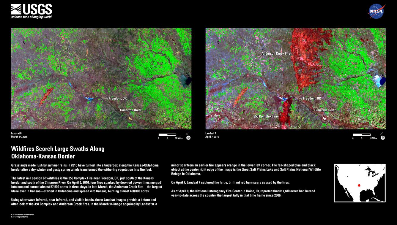
Grasslands made lush by summer rains in 2015 have turned into a tinderbox along the Kansas-Oklahoma border after a dry winter and gusty spring winds transformed the withering vegetation into fire fuel.
The latest in a season of wildfires is the 350 Complex Fire near Freedom, OK, just south of the Kansas border and south of the Cimarron River. On April 5, 2016, four fires sparked by downed power lines merged into one and burned almost 57,500 acres in three days. In late March, the Anderson Creek Fire—the largest blaze ever in Kansas—started in Oklahoma and spread into Kansas, burning almost 400,000 acres.
Using shortwave infrared, near infrared, and visible bands, these Landsat images provide a before and after look at the 350 Complex and Anderson Creek fires. In the March 14 image acquired by Landsat 8, a minor scar from an earlier fire appears orange in the lower left corner. The fan-shaped blue and black object at the center right edge of the image is the Great Salt Plains Lake and Salt Plains National Wildlife Refuge in Oklahoma.
On April 7, Landsat 7 captured the large, brilliant red burn scars caused by the fires.
As of April 8, the National Interagency Fire Center in Boise, ID, reported that 817,480 acres had burned year-to-date across the country, the largest tally in that time frame since 2006.
Hungry for some science, but you don’t have time for a full-course research plate? Then check out USGS Science Snippets, our snack-sized science series that focuses on the fun, weird, and fascinating stories of USGS science.
Get Our News
These items are in the RSS feed format (Really Simple Syndication) based on categories such as topics, locations, and more. You can install and RSS reader browser extension, software, or use a third-party service to receive immediate news updates depending on the feed that you have added. If you click the feed links below, they may look strange because they are simply XML code. An RSS reader can easily read this code and push out a notification to you when something new is posted to our site.