An official website of the United States government
Here's how you know
Official websites use .gov
A .gov website belongs to an official government organization in the United States.
Secure .gov websites use HTTPS
A lock () or https:// means you’ve safely connected to the .gov website. Share sensitive information only on official, secure websites.
The USGS has completed the second phase of releasing thousands of photos and videos of the seafloor and coastline through their Coastal and Marine Video and Photography Portal.
Most of these marine and coastal scenes have never been seen before or mapped at this level of detail. A more accurate perspective of these areas helps coastal managers make important decisions that range from protecting habitats to understanding hazards and managing land use.
This USGS portal is unique, due to the sheer quantity and quality of data presented. It is the largest database of its kind, providing detailed and fine-scale representations of the coast and seafloor. The “geospatial context” is also unique, with maps that display imagery in the geographic location where the images were recorded.
Prior to development of the data portal, retrieving this imagery most often required internal USGS access with specific hardware and software. Furthermore, it was difficult to manage and challenging to share such a large amount of information.
During the first phase earlier this year, the USGS published imagery and video of California, Massachusetts, the Gulf of Mexico and the mid-Atlantic coasts. This second phase includes Puget Sound, Hawaii, Alaska, Rhode Island, Connecticut and Long Island Sound, as well as additional products from Massachusetts and nine pre-storm and post hurricane photo datasets from the Gulf and Atlantic Coasts. Video and photographs will be continuously added as they are collected; archived imagery will also be incorporated soon.
In total, approximately 165,500 photographs have been collected as well as 1,210 hours of trackline video covering almost 3,200 miles of coastline.
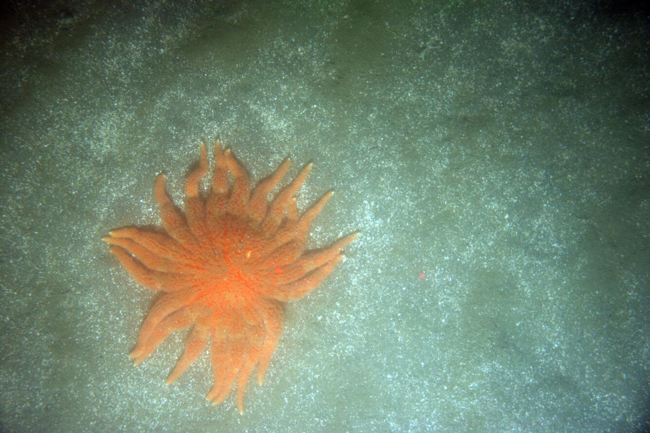
This photograph is of the seafloor off the California coast and shows coarse sand, shells and a sunflower sea star. This photograph supports the California Seafloor Mapping Program (CSMP), which was initiated in 2007 by the California Ocean Protection Council. Data collected during this project reveal the seafloor offshore of the California coast in unprecedented detail and provide an ecosystem context for the effective management of this precious marine resource. Photo Credit: USGS
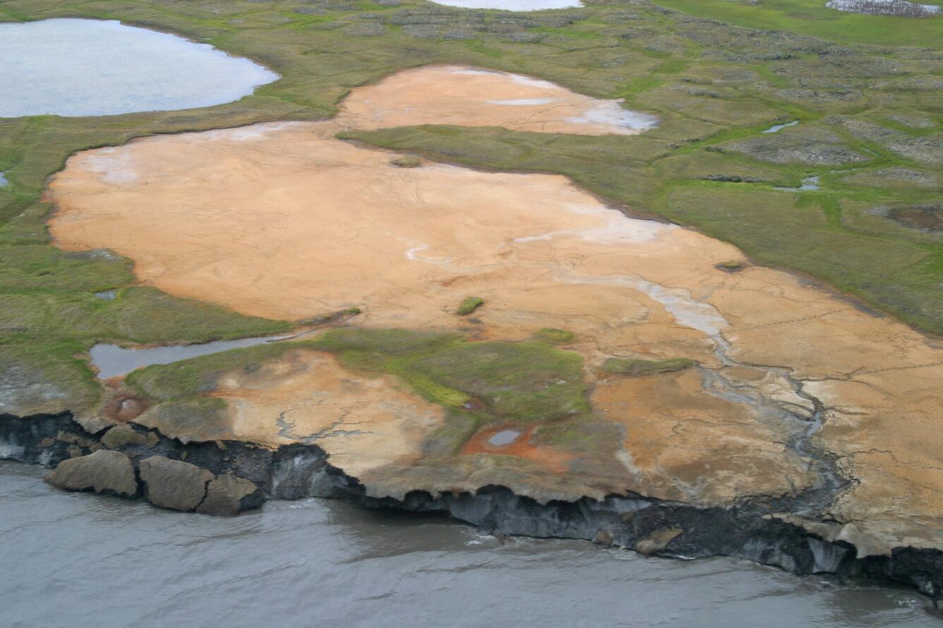
This photograph shows three caribou escape the mosquitos on the mudflats of Kasegaluk Lagoon on the Chukchi Sea coast of Alaska. Coastal erosion along the Arctic coast is chronic, widespread and potentially accelerating, posing threats to infrastructure important for defense and energy purposes, natural shoreline habitats and nearby Native communities. To help address these concerns, the USGS is collecting information on past and present shoreline changes along the conterminous United States and parts of Alaska and Hawaii. Photo Credit: Ann Gibbs and Bruce Richmond, USGS
Photograph showing the seafloor off the California coast. This photograph supports the California Seafloor Mapping Program (CSMP), which was initiated in 2007 by the California Ocean Protection Council. Data collected during this project reveal the seafloor offshore of the California coast in unprecedented detail and provide an ecosystem context for the effective management of this precious marine resource. Photo Credit: USGS
This photograph is of the seafloor off the Massachusetts coast and shows a lobster, sponges and brachiopods on cobbles and ledge covered with seaweed, bubblegum algae and red filamentous algae. This photograph was collected as part of USGS research in collaboration with the Massachusetts Office of Coastal Zone Management to support development of the Massachusetts Ocean Management Plan and management of the state's waters. Photo Credit: USGS
This photograph is of the seafloor off the Massachusetts coast and shows sea stars, blood stars, blood drop tunicates, mussels and barnacles on cobbles and boulders covered with bubblegum algae and red filamentous algae. This photograph was collected as part of USGS research in collaboration with the Massachusetts Office of Coastal Zone Management to support development of the Massachusetts Ocean Management Plan and management of the state's waters.Photo Credit: USGS
This oblique aerial photograph is of Flaxman Island off the Alaska coast and shows a tapped thermokarst lakes, caribou tracks and ice-rich bluffs that are eroding. Coastal erosion along the Arctic coast is chronic, widespread and potentially accelerating, posing threats to infrastructure important for defense and energy purposes, natural shoreline habitats and nearby Native communities. To help address these concerns, the USGS is collecting information on past and present shoreline changes along the conterminous United States and parts of Alaska and Hawaii. Photo Credit: Ann Gibbs and Bruce Richmond, USGS
This photograph shows birds taking flight near Icy Cape on the Chukchi Sea coast of Alaska, an area that provides habitat for a variety of avian species. Coastal erosion along the Arctic coast is chronic, widespread and potentially accelerating, posing threats to infrastructure important for defense and energy purposes, natural shoreline habitats and nearby Native communities. To help address these concerns, the USGS is collecting information on past and present shoreline changes along the conterminous United States and parts of Alaska and Hawaii. Photo Credit: Ann Gibbs and Bruce Richmond, USGS
This photograph is of the seafloor off the California coast and shows rock outcrop, encrusting sponge, cup corals, red sea star and a female kelp greenling. This photograph supports the California Seafloor Mapping Program (CSMP), which was initiated in 2007 by the California Ocean Protection Council. Data collected during this project reveal the seafloor offshore of the California coast in unprecedented detail and provide an ecosystem context for the effective management of this precious marine resource. Photo Credit: USGS
This photograph shows snow and ice melt along the rolling hills and coastal bluffs near Cape Sabine on the western Chukchi Sea coast of Alaska. Coastal erosion along the Arctic coast is chronic, widespread and potentially accelerating, posing threats to infrastructure important for defense and energy purposes, natural shoreline habitats and nearby Native communities. To help address these concerns, the USGS is collecting information on past and present shoreline changes along the conterminous United States and parts of Alaska and Hawaii. Photo Credit: Ann Gibbs and Bruce Richmond, USGS
This photograph shows ice-wedge polygons and an eroding shoreline at Cape Halkett on the Beaufort Sea coast of Alaska. Coastal erosion along the Arctic coast is chronic, widespread and potentially accelerating, posing threats to infrastructure important for defense and energy purposes, natural shoreline habitats and nearby Native communities. To help address these concerns, the USGS is collecting information on past and present shoreline changes along the conterminous United States and parts of Alaska and Hawaii. Photo Credit: Ann Gibbs and Bruce Richmond, USGS
This photograph is of the seafloor off the California coast and shows jellyfish in a water column. This photograph supports the California Seafloor Mapping Program (CSMP), which was initiated in 2007 by the California Ocean Protection Council. Data collected during this project reveal the seafloor offshore of the California coast in unprecedented detail and provide an ecosystem context for the effective management of this precious marine resource. Photo Credit: USGS
This photograph is of the seafloor off the Massachusetts coast and shows sand dollars and a few shell fragments on a sandy seabed. This photograph was collected as part of USGS research in collaboration with the Massachusetts Office of Coastal Zone Management to support development of the Massachusetts Ocean Management Plan and management of the state's waters. Photo Credit: USGS
This photograph shows two grizzly bears frolic on the tundra near the Avak River on the Chukchi Sea coast of Alaska. Coastal erosion along the Arctic coast is chronic, widespread and potentially accelerating, posing threats to infrastructure important for defense and energy purposes, natural shoreline habitats and nearby Native communities. To help address these concerns, the USGS is collecting information on past and present shoreline changes along the conterminous United States and parts of Alaska and Hawaii. Photo Credit: Ann Gibbs and Bruce Richmond, USGS
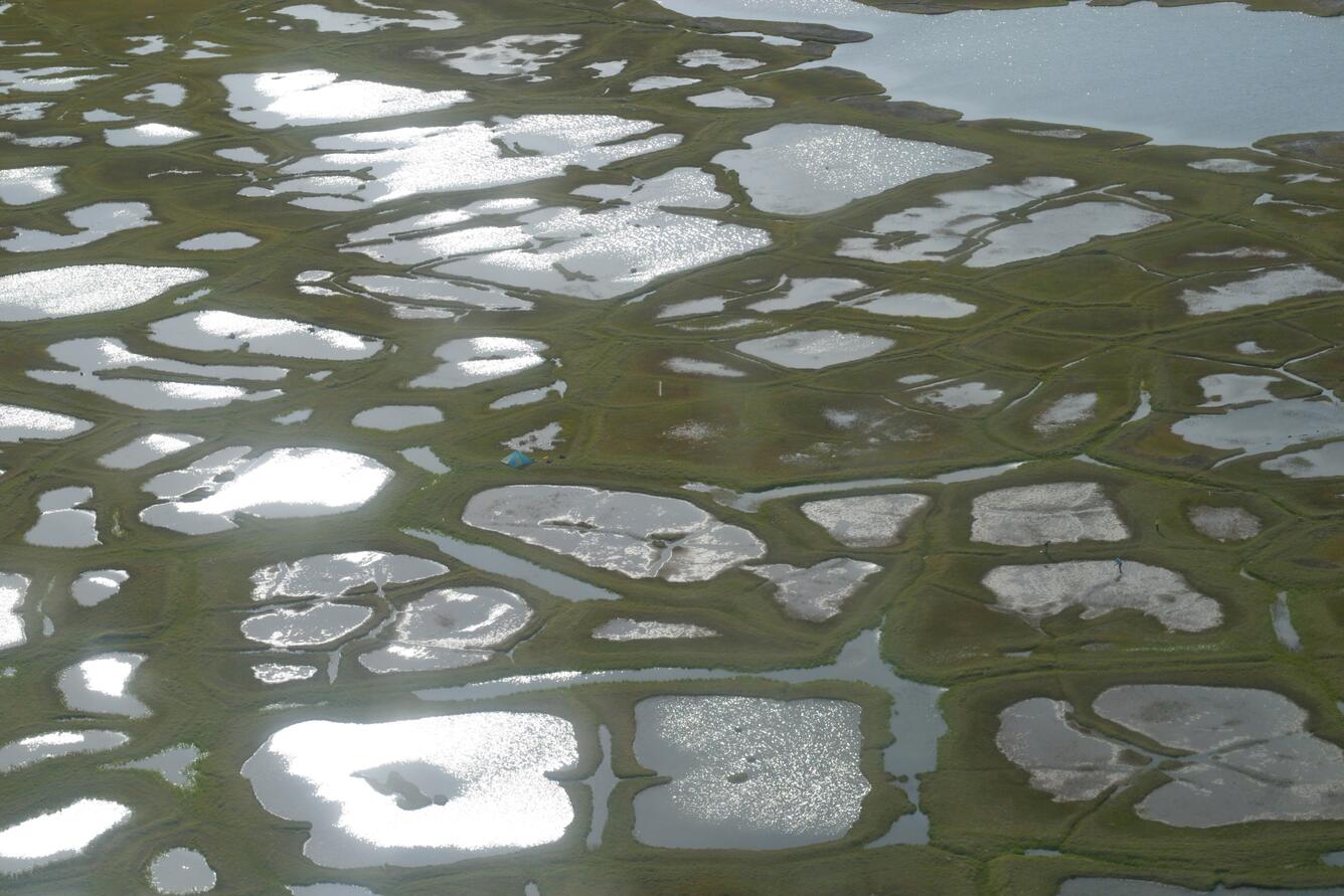
This photograph shows USGS scientists collecting data off the Arctic Coastal Plain of northern Alaska. Coastal erosion along the Arctic coast is chronic, widespread and potentially accelerating, posing threats to infrastructure important for defense and energy purposes, natural shoreline habitats and nearby Native communities. To help address these concerns, the USGS is collecting information on past and present shoreline changes along the conterminous United States and parts of Alaska and Hawaii. Photo Credit: Ann Gibbs and Bruce Richmond, USGS
This photograph is of the seafloor on the Rhode Island coast and shows a skate on a fine-grained, likely silty or muddy seafloor. This photograph was collected to support research and management activities (e.g., wind farms and fisheries) along the Rhode Island inner continental shelf. Photo Credit: USGS
This photograph is of the seafloor in the Woods Hole Passage and shows a mussel reef and boring sponge. This photograph was collected as part of the Southeastern Massachusetts Mapping Cooperative between the USGS and the National Oceanic and Atmospheric Administration (NOAA) during a sampling survey of Woods Hole Passage, which is a treacherous waterway with stong tidal currents.Photo Credit: USGS
This photograph is of the Puget Sound seafloor and shows an area mixed with mud, gravel and cobble that is occupied by bivalve molluscs with exposed siphons, a sea star and metridium. This image was collected as part of USGS efforts to help with rockfish recovery in the Puget Sound. Scientists are mapping their ecosystem and habitat to understand population distribution. Photo Credit: USGS
This photograph is of the Puget Sound seafloor and shows a sandy area with partial hydroid and algae cover occupied by two sea pens. This image was collected as part of USGS efforts to help with rockfish recovery in the Puget Sound. Scientists are mapping their ecosystem and habitat to understand population distribution. Photo Credit: USGS
A polar bear stands on a low-lying barrier shoal near the Huluhula River on the Beaufort Sea coast of Alaska. Coastal erosion along the Arctic coast is chronic, widespread and potentially accelerating, posing threats to infrastructure important for defense and energy purposes, natural shoreline habitats and nearby Native communities. To help address these concerns, the USGS is collecting information on past and present shoreline changes along the conterminous United States and parts of Alaska and Hawaii. Photo Credit: Ann Gibbs and Bruce Richmond, USGS
Coral growth offshore of the Hawaiian Island of Kahoʻolawe has been significantly impacted by the island's deforestation and resulting erosion and sediment run-off into the nearshore environment. This image is of a coral reef in deeper waters offshore of Kahoʻolawe. Photo Credit: Ann E. Gibbs, Susan A. Cochran, Joshua B. Logan and Eric E. Grossman, USGS
Get Our News
These items are in the RSS feed format (Really Simple Syndication) based on categories such as topics, locations, and more. You can install and RSS reader browser extension, software, or use a third-party service to receive immediate news updates depending on the feed that you have added. If you click the feed links below, they may look strange because they are simply XML code. An RSS reader can easily read this code and push out a notification to you when something new is posted to our site.