
On Demand Custom Topographic Maps
The U.S. Geological Survey continues to advance the topographic map with on-demand custom mapping.
For the past 135 years, the U.S. Geological Survey (USGS) has made topographic maps based on predetermined criteria, such as quadrangles and annual schedules. Now, with a touch of a button, a person can get a topographic map of whatever location they want, whenever they want using a new pilot online application available from USGS called topoBuilder.
The geographic data available from The National Map and advancements in technology have enabled the USGS to evolve and modernize USGS map production processes over the last several years. In 2019, USGS started to develop a tool for people to make on demand topographic maps and now they can do just that.
“We’re really excited to be able to offer this pilot application for our users, and we hope that people will take advantage of it,” said Ariel Doumbouya, project lead for topoBuilder.

The topoBuilder application is designed to assist recreationalists and the general public that use cartographic products in their work and daily lives as well as support resource management, natural hazard risk reduction, national health and security, and sustainable energy development.
“Let’s say you’re interested in visiting Horseshoe Bend near Page, Arizona and you want to get topo maps for that area,” explains Doumbouya. “If you’re relying on the US Topo maps that the USGS generates based on the 7.5-minute map series, you’d need four separate maps to cover that area. Now, with topoBuilder, you’d need just one.”
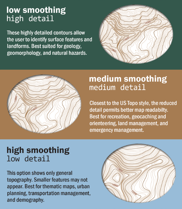
From the topoBuilder online application, users can center their area of interest and generate an on demand topographic map (OnDemand Topo) anywhere in the continental United States (CONUS), Hawaii, Alaska, and the U.S. Territories (Guam, Puerto Rico, American Samoa, Northern Mariana Islands, and U.S. Virgin Islands). The new topographic map (On Demand Topo) will be created from the best available National Map data, cartography, and standards. (Fig.1)
“One of the things I’m most pleased about with topoBuilder is that, for the first time, you can get topo maps of all the US Territories, not just the States,” said Doumbouya. “Although these areas have limited data, if you’re interested in topo maps of Lata Mountain in American Samoa, you can get a topographic map of that area as easily as you can get maps of Pikes Peak in Colorado.”
USGS topographic maps have evolved since the 1800s, from paper maps using lithographic printing technology to the digital US Topo, the current topographic map series. Each iteration has boosted the value of USGS topographic maps within many communities and met an increasingly diverse set of customer needs. Collaboration with federal agencies as well as the implementation of advanced mapping practices have further increased the number and variety of uses for US Topo map products among customers and partners. The topoBuilder online application and resulting topographic maps represent the next step forward in that evolution.
“topoBuilder creates a unique opportunity for the USGS to serve new and existing needs,” said Doumbouya. “You don’t need specialized skills or special software to be able to use topoBuilder; it’s all right there in the application. As we look to the future, the USGS will continue to enhance this application to provide additional user customization options, map types, and data enhancements.”
The topoBuilder application and user guide are available here. This initial public offering is a limited time pilot which is designed to support USGS evaluating user demand for custom topographic maps. USGS will use information from the pilot to develop plans for future phases. Once the pilot closes, information on future phases will be shared on The National Map webpages.
We invite and encourage you to explore topoBuilder.
If you have questions, need help, or would like additional information on this new capability, please contact us at tnm_help@usgs.gov.
Happy mapping!

Get Our News
These items are in the RSS feed format (Really Simple Syndication) based on categories such as topics, locations, and more. You can install and RSS reader browser extension, software, or use a third-party service to receive immediate news updates depending on the feed that you have added. If you click the feed links below, they may look strange because they are simply XML code. An RSS reader can easily read this code and push out a notification to you when something new is posted to our site.