


Buildings destroyed during Hurricane Maria in Rincón, Puerto Rico. Photograph taken on August 28, 2021, almost four years after the hurricane.
Coastal Hazards and Resilience
Coastal hazards such as hurricanes, sea-level rise, flooding, erosion, and extreme storms can threaten lives and health, property, and valuable habitats along our nation’s coasts. USGS science, products, and tools provide the Nation with robust and accessible scientific research to help partners anticipate, prepare for, adapt to, and mitigate coastal hazards.
While coastal change is natural, hazards arise when these changes threaten lives or put communities and habitats at risk. Some of these hazards can occur abruptly such as earthquakes, landslides, and tsunamis; or within short periods of time such as hurricanes and extreme storms. Others happen gradually over time like sea-level rise, erosion, or saltwater intrusion into groundwater. The USGS is a leader in natural hazards research and addresses coastal hazards by conducting basic and applied research, developing tools to assess risk, and providing data and information to stakeholders and partners to enhance preparedness.
Tools and Technology for Coastal Resilience
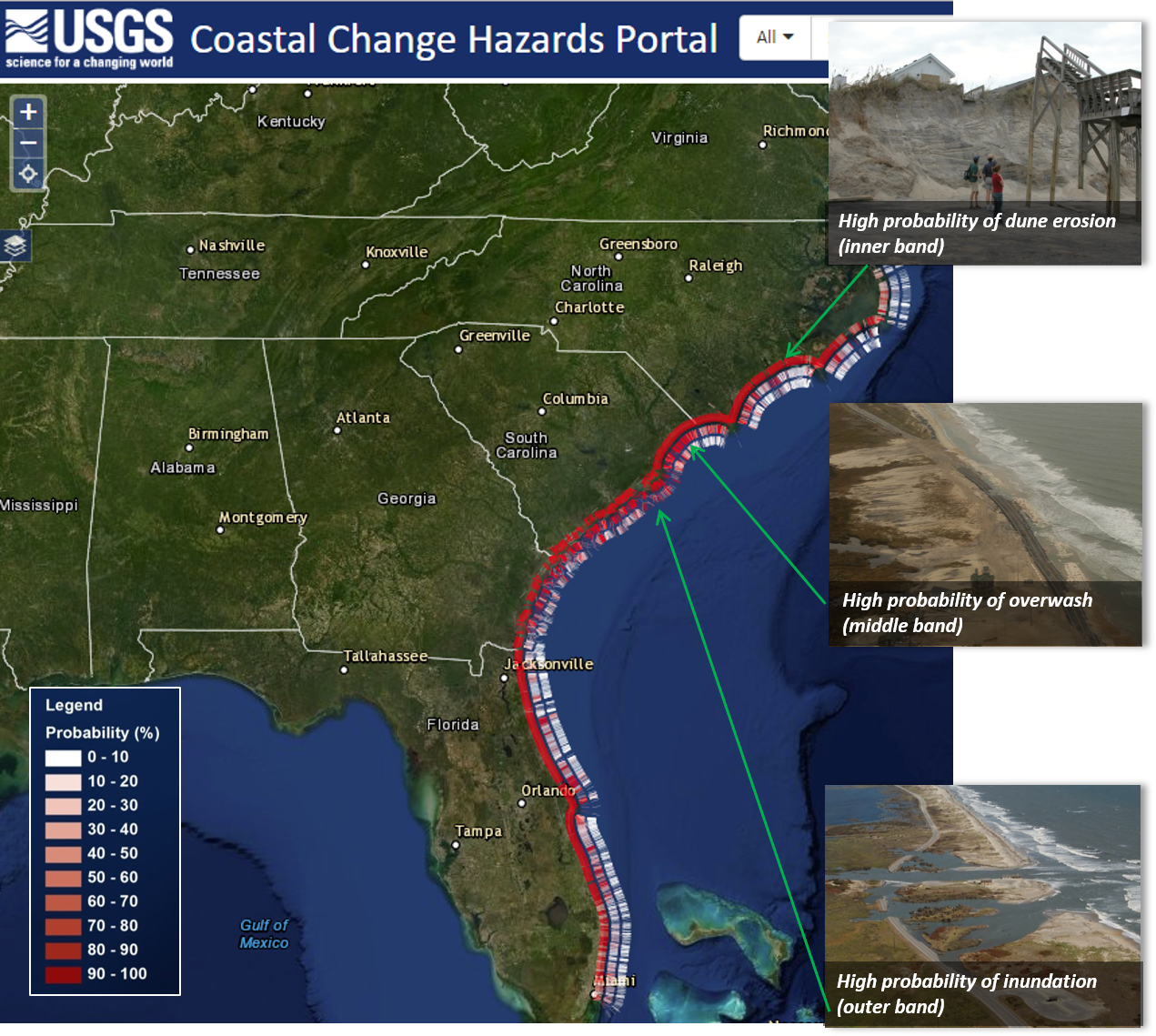
The USGS collection of coastal tools provides information on coastal hazards at scales useful for local communities, regional managers, and decision makers. For example, the USGS Coastal Change Hazards Portal allows users to explore the potential for storm-induced coastal erosion, forecasts of extreme water levels, historical shoreline change, and vulnerability to sea-level rise. These data and products are immensely valuable for assisting communities with efforts to bolster coastal resilience and reduce vulnerability to coastal hazards.


Sources/Usage: Public Domain. View Media Details

Sources/Usage: Public Domain. View Media Details
Hurricane Response
Hurricanes are an example of one type of hazard that can cause significant changes to the coast. When a storm is approaching, USGS activates the Coastal Storm Response team, which is comprised of scientists and technicians with multidisciplinary expertise to share information, forecast impacts, and help communities in the storm’s track prepare for and recover from powerful storms. Take a quiz to learn about the breadth of USGS science that goes into helping storm forecasters, emergency responders, communities, resource managers and other decision-makers prepare for, cope with, and recover from storms.

Sources/Usage: Public Domain. View Media Details
Water and Flooding
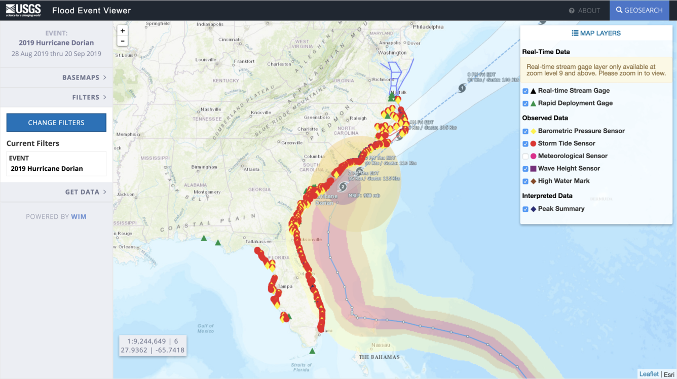
The USGS maintains a nationwide network of permanent water gages to measure and monitor surface water flow, groundwater levels and more. USGS also deploys rapid response water level gages and hurricane storm tide sensors when extreme storms or other hazardous conditions threaten our coast. Data from these sensors are displayed on the USGS Flood Event Viewer. In collaboration with stakeholders, USGS has constructed a national Surge, Wave, and Tide Hydrodynamics (SWaTH) Network that monitors and documents the height, extent, and timing of storm surge. These data are provided to scientists, stakeholders, and the public in real time through the National Water Dashboard.

Sources/Usage: Public Domain. View Media Details
Coastal Geologic Hazards
The nation's coastlines are also vulnerable to more abrupt, interrelated hazards posed by earthquakes, tsunamis, and land-based failures like landslides. USGS studies the processes and effects of earthquakes, landslides, and modern-day and prehistoric tsunamis using a variety of methods. These data are used to generate models, simulations, and probabilities of the likelihood of these hazards with the goal of providing relevant scientific information that can be used to help prevent loss of life, injuries, and property damage.
Other long-term hazardous processes studied by USGS include the seasonal freezing, thawing, and erosion of permafrost coasts that threaten coastal communities and infrastructure in Arctic Alaska.

Sources/Usage: Public Domain. View Media Details
Natural Barriers
While many hazards threaten our coasts, Earth has provided numerous natural structures to protect them such as barrier islands, wetlands, and reefs. For instance, coral reefs act as very effective buffers that break waves and limit flooding in tropical states and U.S. territories. USGS research has quantified the economic benefits of these natural ecosystems, as well as the predicted effects of restoration, which will help inform partners working to protect and conserve coral reefs around the world.

Sources/Usage: Public Domain. View Media Details
Invisible Hazards
Less visible hazards such as toxins, pathogens, saltwater intrusion, and wastewater discharge threaten coastal ecosystems and wildlife as well as the people who live, work, and play along our coasts. These contaminants can enter our coastal waterways through seepage, spills, runoff, or through groundwater discharge. These substances can also become entrained in sediments that can impact ecological health. The USGS monitors water quality, sediments, and living organisms in our coastal regions to track whether contamination has occurred in our waterways to help inform water managers when to treat, close, or otherwise mitigate these hazardous scenarios.
Science
Coastal Climate Impacts
The impacts of climate change and sea-level rise around the Pacific and Arctic Oceans can vary tremendously. Thus far the vast majority of national and international impact assessments and models of coastal climate change have focused on low-relief coastlines that are not near seismically active zones. Furthermore, the degree to which extreme waves and wind will add further stress to coastal...
Dynamic coastlines along the western U.S.
The west coast of the United States is extremely complex and changeable because of tectonic activity, mountain building, and land subsidence. These active environments pose a major challenge for accurately assessing climate change impacts, since models were historically developed for more passive sandy coasts.
Role of Reefs in Coastal Protection
We are combining ocean, engineering, ecologic, social, and economic modeling to provide a high-resolution, rigorous, spatially-explicit valuation of the coastal flood protection benefits provided by coral reefs and the cost effectiveness of reef restoration for enhancing those benefits.
Low-lying areas of tropical Pacific islands
Sea level is rising faster than projected in the western Pacific, so understanding how wave-driven coastal flooding will affect inhabited, low-lying islands—most notably, the familiar ring-shaped atolls—as well as the low-elevation areas of high islands in the Pacific Ocean, is critical for decision-makers in protecting infrastructure or relocating resources and people.
Landscape Response to Disturbance
This project characterizes and measures sediment-related effects of landscape disturbances (such as major storms, drought, or wildfire) and river management. We focus primarily on the U.S. west coast, and our work relates to natural hazards and resource management.
Multimedia

Rincón, Puerto Rico, View 1
Buildings destroyed during Hurricane Maria in Rincón, Puerto Rico. Photograph taken on August 28, 2021, almost four years after the hurricane.

USGS Coastal Change Hazards
The USGS Coastal Change Hazards team works to identify and address the Nation’s coastal change hazards problems. By integrating research, technical capabilities and applications, and stakeholder engagement and communications, the Coastal Change Hazards team develops robust and accessible coastal change assessments, forecasts, and tools that help improve the lives,
The USGS Coastal Change Hazards team works to identify and address the Nation’s coastal change hazards problems. By integrating research, technical capabilities and applications, and stakeholder engagement and communications, the Coastal Change Hazards team develops robust and accessible coastal change assessments, forecasts, and tools that help improve the lives,

Image of the Week: Mudslide Cuts Through Big Sur Burn Scar
A mudslide near the 2020 Dolan Fire's ignition point chopped through a chunk of California's scenic State Highway 1 in late January.
The Dolan Fire began near Big Sur on August 18th, 2020. It scarred nearly 125,000 acres before being fully contained in December.
A mudslide near the 2020 Dolan Fire's ignition point chopped through a chunk of California's scenic State Highway 1 in late January.
The Dolan Fire began near Big Sur on August 18th, 2020. It scarred nearly 125,000 acres before being fully contained in December.

Portable single-beam echo sounder set-up
Marine engineering technician Pete Dal Ferro sets up a newly acquired, portable, single-beam echo sounder on the San Lorenzo River in Santa Cruz, California. The new device, called CEESCOPE, collects bathymetric (depth) data and also records features of the subsurface.
Marine engineering technician Pete Dal Ferro sets up a newly acquired, portable, single-beam echo sounder on the San Lorenzo River in Santa Cruz, California. The new device, called CEESCOPE, collects bathymetric (depth) data and also records features of the subsurface.

USGS Erosion Simulation Video
This video demonstrates a simulation of how storms can impact sandy coastlines through processes such as erosion. This demonstration is conducted at outreach events by scientists at the St. Petersburg Coastal and Marine Science Center. The activity can also be re-created at home or in the classroom.
This video demonstrates a simulation of how storms can impact sandy coastlines through processes such as erosion. This demonstration is conducted at outreach events by scientists at the St. Petersburg Coastal and Marine Science Center. The activity can also be re-created at home or in the classroom.

How Our Reefs Protect Us: Valuing the Benefits of U.S. Reefs
The degradation of coastal habitats, particularly coral reefs, raises risks by increasing the exposure of coastal communities to flooding hazards during storms. The protective services of these natural defenses are not assessed in the same rigorous economic terms as artificial defenses, such as seawalls, and therefore often are not considered in decision-making.
The degradation of coastal habitats, particularly coral reefs, raises risks by increasing the exposure of coastal communities to flooding hazards during storms. The protective services of these natural defenses are not assessed in the same rigorous economic terms as artificial defenses, such as seawalls, and therefore often are not considered in decision-making.

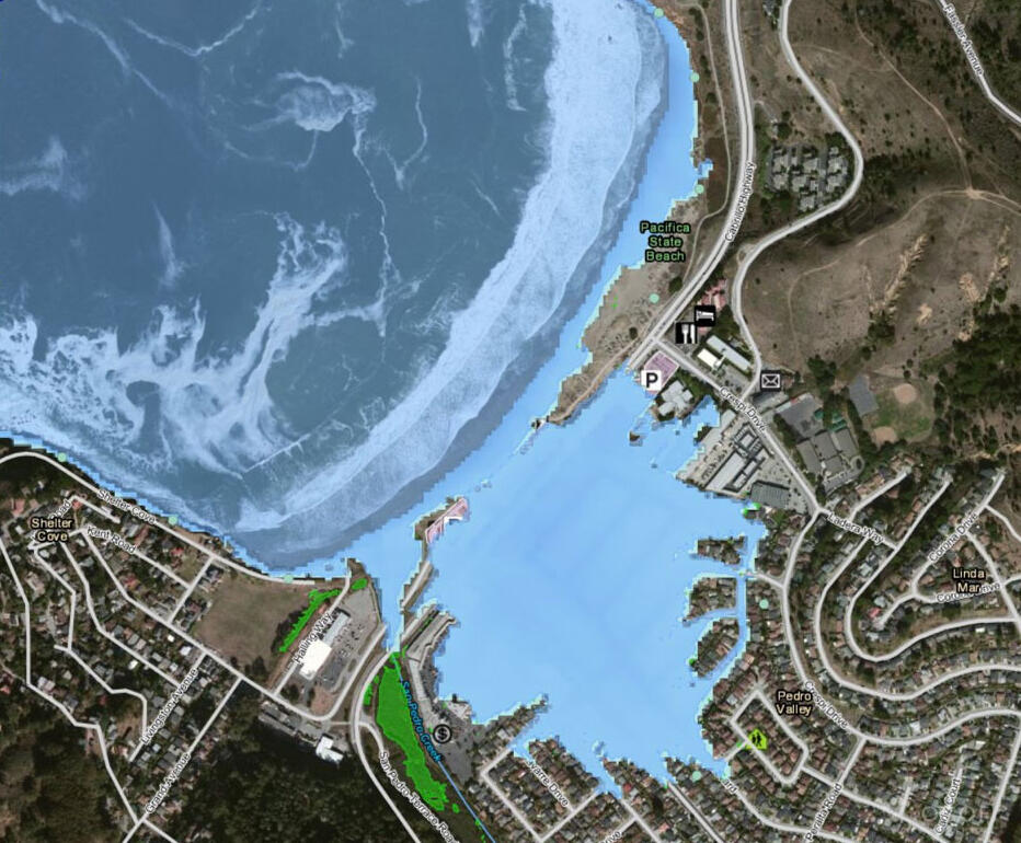
Simulated flooding for 100-year storm event, San Juan
Map showing the simulated flooding for a 100-year storm event with (blue) and without (red) coral reefs in San Juan, Puerto Rico. The red area thus represents the area protected by coral reefs.
Map showing the simulated flooding for a 100-year storm event with (blue) and without (red) coral reefs in San Juan, Puerto Rico. The red area thus represents the area protected by coral reefs.

Whiskey Creek section of Whiskeytown Lake
In the aftermath of the 2018 Carr Fire, northern California, sediment has eroded from burned hillslopes and accumulated in some areas of Whiskeytown Lake. A recent sediment deposit is shown here in the Whiskey Creek section of the lake.
In the aftermath of the 2018 Carr Fire, northern California, sediment has eroded from burned hillslopes and accumulated in some areas of Whiskeytown Lake. A recent sediment deposit is shown here in the Whiskey Creek section of the lake.

Tuolumne watershed landslides
USGS scientists examining landslides in the Tuolumne watershed, California, caused by an extreme rain event in 2018.
USGS scientists examining landslides in the Tuolumne watershed, California, caused by an extreme rain event in 2018.

- Overview
While coastal change is natural, hazards arise when these changes threaten lives or put communities and habitats at risk. Some of these hazards can occur abruptly such as earthquakes, landslides, and tsunamis; or within short periods of time such as hurricanes and extreme storms. Others happen gradually over time like sea-level rise, erosion, or saltwater intrusion into groundwater. The USGS is a leader in natural hazards research and addresses coastal hazards by conducting basic and applied research, developing tools to assess risk, and providing data and information to stakeholders and partners to enhance preparedness.
Tools and Technology for Coastal Resilience
The USGS collection of coastal tools provides information on coastal hazards at scales useful for local communities, regional managers, and decision makers. For example, the USGS Coastal Change Hazards Portal allows users to explore the potential for storm-induced coastal erosion, forecasts of extreme water levels, historical shoreline change, and vulnerability to sea-level rise. These data and products are immensely valuable for assisting communities with efforts to bolster coastal resilience and reduce vulnerability to coastal hazards.


 Sources/Usage: Public Domain. View Media Details
USGS uses a variety of coastal tools and technology to study coastal hazards. These data and tools are useful for coastal managers and planners who need to make well-informed, science-based decisions to enhance coastal resilience. View Media.
Sources/Usage: Public Domain. View Media DetailsThis photograph of Hurricane Joaquin was taken by NOAA's GOES West satellite on 10/1/2015. Hurricane Response
Hurricanes are an example of one type of hazard that can cause significant changes to the coast. When a storm is approaching, USGS activates the Coastal Storm Response team, which is comprised of scientists and technicians with multidisciplinary expertise to share information, forecast impacts, and help communities in the storm’s track prepare for and recover from powerful storms. Take a quiz to learn about the breadth of USGS science that goes into helping storm forecasters, emergency responders, communities, resource managers and other decision-makers prepare for, cope with, and recover from storms.
Sources/Usage: Public Domain. View Media DetailsThe USGS National Water Dashboard shows the flooding effects associated with Hurricane Ian, on September 29, 2022, with black dots and pink circles showing river flood stage conditions, some of which correspond to all-time-high records for this day of the year. Visit the National Water Dashboard to learn more. Water and Flooding
The USGS maintains a nationwide network of permanent water gages to measure and monitor surface water flow, groundwater levels and more. USGS also deploys rapid response water level gages and hurricane storm tide sensors when extreme storms or other hazardous conditions threaten our coast. Data from these sensors are displayed on the USGS Flood Event Viewer. In collaboration with stakeholders, USGS has constructed a national Surge, Wave, and Tide Hydrodynamics (SWaTH) Network that monitors and documents the height, extent, and timing of storm surge. These data are provided to scientists, stakeholders, and the public in real time through the National Water Dashboard.
Sources/Usage: Public Domain. View Media DetailsA home with severe damage caused by a massive, highly destructive tsunami. Coastal Geologic Hazards
The nation's coastlines are also vulnerable to more abrupt, interrelated hazards posed by earthquakes, tsunamis, and land-based failures like landslides. USGS studies the processes and effects of earthquakes, landslides, and modern-day and prehistoric tsunamis using a variety of methods. These data are used to generate models, simulations, and probabilities of the likelihood of these hazards with the goal of providing relevant scientific information that can be used to help prevent loss of life, injuries, and property damage.
Other long-term hazardous processes studied by USGS include the seasonal freezing, thawing, and erosion of permafrost coasts that threaten coastal communities and infrastructure in Arctic Alaska.
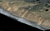
Sources/Usage: Public Domain. View Media DetailsWaves crash against a beach in Isla de Mona, Puerto Rico. Natural Barriers
While many hazards threaten our coasts, Earth has provided numerous natural structures to protect them such as barrier islands, wetlands, and reefs. For instance, coral reefs act as very effective buffers that break waves and limit flooding in tropical states and U.S. territories. USGS research has quantified the economic benefits of these natural ecosystems, as well as the predicted effects of restoration, which will help inform partners working to protect and conserve coral reefs around the world.
Sources/Usage: Public Domain. View Media DetailsUSGS deployed this buoy platform with connected water quality equipment in Saugatuck Harbor, CT in May 2022. Invisible Hazards
Less visible hazards such as toxins, pathogens, saltwater intrusion, and wastewater discharge threaten coastal ecosystems and wildlife as well as the people who live, work, and play along our coasts. These contaminants can enter our coastal waterways through seepage, spills, runoff, or through groundwater discharge. These substances can also become entrained in sediments that can impact ecological health. The USGS monitors water quality, sediments, and living organisms in our coastal regions to track whether contamination has occurred in our waterways to help inform water managers when to treat, close, or otherwise mitigate these hazardous scenarios.
Science
Coastal Climate Impacts
The impacts of climate change and sea-level rise around the Pacific and Arctic Oceans can vary tremendously. Thus far the vast majority of national and international impact assessments and models of coastal climate change have focused on low-relief coastlines that are not near seismically active zones. Furthermore, the degree to which extreme waves and wind will add further stress to coastal...Dynamic coastlines along the western U.S.
The west coast of the United States is extremely complex and changeable because of tectonic activity, mountain building, and land subsidence. These active environments pose a major challenge for accurately assessing climate change impacts, since models were historically developed for more passive sandy coasts.Role of Reefs in Coastal Protection
We are combining ocean, engineering, ecologic, social, and economic modeling to provide a high-resolution, rigorous, spatially-explicit valuation of the coastal flood protection benefits provided by coral reefs and the cost effectiveness of reef restoration for enhancing those benefits.Low-lying areas of tropical Pacific islands
Sea level is rising faster than projected in the western Pacific, so understanding how wave-driven coastal flooding will affect inhabited, low-lying islands—most notably, the familiar ring-shaped atolls—as well as the low-elevation areas of high islands in the Pacific Ocean, is critical for decision-makers in protecting infrastructure or relocating resources and people.Landscape Response to Disturbance
This project characterizes and measures sediment-related effects of landscape disturbances (such as major storms, drought, or wildfire) and river management. We focus primarily on the U.S. west coast, and our work relates to natural hazards and resource management.Multimedia
Rincón, Puerto Rico, View 1Buildings destroyed during Hurricane Maria in Rincón, Puerto Rico. Photograph taken on August 28, 2021, almost four years after the hurricane.
Buildings destroyed during Hurricane Maria in Rincón, Puerto Rico. Photograph taken on August 28, 2021, almost four years after the hurricane.
USGS Coastal Change HazardsThe USGS Coastal Change Hazards team works to identify and address the Nation’s coastal change hazards problems. By integrating research, technical capabilities and applications, and stakeholder engagement and communications, the Coastal Change Hazards team develops robust and accessible coastal change assessments, forecasts, and tools that help improve the lives,
The USGS Coastal Change Hazards team works to identify and address the Nation’s coastal change hazards problems. By integrating research, technical capabilities and applications, and stakeholder engagement and communications, the Coastal Change Hazards team develops robust and accessible coastal change assessments, forecasts, and tools that help improve the lives,
Image of the Week: Mudslide Cuts Through Big Sur Burn ScarA mudslide near the 2020 Dolan Fire's ignition point chopped through a chunk of California's scenic State Highway 1 in late January.
The Dolan Fire began near Big Sur on August 18th, 2020. It scarred nearly 125,000 acres before being fully contained in December.
A mudslide near the 2020 Dolan Fire's ignition point chopped through a chunk of California's scenic State Highway 1 in late January.
The Dolan Fire began near Big Sur on August 18th, 2020. It scarred nearly 125,000 acres before being fully contained in December.
Portable single-beam echo sounder set-upMarine engineering technician Pete Dal Ferro sets up a newly acquired, portable, single-beam echo sounder on the San Lorenzo River in Santa Cruz, California. The new device, called CEESCOPE, collects bathymetric (depth) data and also records features of the subsurface.
Marine engineering technician Pete Dal Ferro sets up a newly acquired, portable, single-beam echo sounder on the San Lorenzo River in Santa Cruz, California. The new device, called CEESCOPE, collects bathymetric (depth) data and also records features of the subsurface.
USGS Erosion Simulation VideoThis video demonstrates a simulation of how storms can impact sandy coastlines through processes such as erosion. This demonstration is conducted at outreach events by scientists at the St. Petersburg Coastal and Marine Science Center. The activity can also be re-created at home or in the classroom.
This video demonstrates a simulation of how storms can impact sandy coastlines through processes such as erosion. This demonstration is conducted at outreach events by scientists at the St. Petersburg Coastal and Marine Science Center. The activity can also be re-created at home or in the classroom.
How Our Reefs Protect Us: Valuing the Benefits of U.S. ReefsThe degradation of coastal habitats, particularly coral reefs, raises risks by increasing the exposure of coastal communities to flooding hazards during storms. The protective services of these natural defenses are not assessed in the same rigorous economic terms as artificial defenses, such as seawalls, and therefore often are not considered in decision-making.
The degradation of coastal habitats, particularly coral reefs, raises risks by increasing the exposure of coastal communities to flooding hazards during storms. The protective services of these natural defenses are not assessed in the same rigorous economic terms as artificial defenses, such as seawalls, and therefore often are not considered in decision-making.
Simulated flooding for 100-year storm event, San JuanMap showing the simulated flooding for a 100-year storm event with (blue) and without (red) coral reefs in San Juan, Puerto Rico. The red area thus represents the area protected by coral reefs.
Map showing the simulated flooding for a 100-year storm event with (blue) and without (red) coral reefs in San Juan, Puerto Rico. The red area thus represents the area protected by coral reefs.
Whiskey Creek section of Whiskeytown LakeIn the aftermath of the 2018 Carr Fire, northern California, sediment has eroded from burned hillslopes and accumulated in some areas of Whiskeytown Lake. A recent sediment deposit is shown here in the Whiskey Creek section of the lake.
In the aftermath of the 2018 Carr Fire, northern California, sediment has eroded from burned hillslopes and accumulated in some areas of Whiskeytown Lake. A recent sediment deposit is shown here in the Whiskey Creek section of the lake.
Tuolumne watershed landslidesUSGS scientists examining landslides in the Tuolumne watershed, California, caused by an extreme rain event in 2018.
USGS scientists examining landslides in the Tuolumne watershed, California, caused by an extreme rain event in 2018.
- Publications
- Science
- Data and More
- Maps
- Multimedia
- News