
Deformation Monitoring Measures Inflation and Deflation of the Ground Surface Active
The land surface moves (deforms) as magma travels below the surface. Deformation measurements are made with several different tools and herald rising magma.
At Cascade volcanoes, CVO scientists make measurements of land-surface movements using the Global Positioning System (GPS). More than 60 GPS stations continuously receive signals from satellites overhead and send the information to CVO, where it is analyzed to track the position of each station in three dimensions to within a small fraction of an inch. The GPS information allows CVO scientists to quickly detect any unusual movements that might occur as a result of magma accumulating beneath a volcano. In addition to continuously-operating GPS stations, CVO scientists conduct repeated temporary, campaign-style, GPS surveys to fill in areas where continuous monitoring is incomplete. They set up temporary GPS stations that receive satellite signals for a few days to months, and then analyze the resulting data together with that from continuously-operating stations. CVO scientists also use a remote-sensing technique called InSAR (interferometric synthetic aperture radar) to map subtle movements of the ground surface from space.
Read about the different ways ground movement can be detected at the Volcano Hazards Program deformation monitoring webpage.
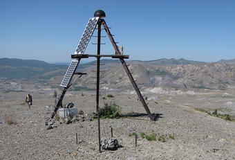