
A view of the highway going over Loveland Pass in Colorado.
Images
Explore our planet through photography and imagery, including climate change and water all the way back to the 1800s when the USGS was surveying the country by horse and buggy.
Filter Total Items: 21608

Loveland Pass Colorado
A view of the highway going over Loveland Pass in Colorado.

Map of seabed geology and sun-illuminated topography, Stellwagen Bank
Map of seabed geology and sun-illuminated topography, Stellwagen Bank Blue and purple = boulder ridges. Redlines = leading edges of sand sheets
Map of seabed geology and sun-illuminated topography, Stellwagen Bank Blue and purple = boulder ridges. Redlines = leading edges of sand sheets

Mesaba Deposit Drill Core (microscope image)
Cross-polarized light photomicrograph of minerals in drill core samples from the Mesaba copper-nickel deposit, Duluth Complex, Minnesota. The number in the upper right hand corner is the drill core number.
Cross-polarized light photomicrograph of minerals in drill core samples from the Mesaba copper-nickel deposit, Duluth Complex, Minnesota. The number in the upper right hand corner is the drill core number.

Models for shoreline change
Parameters considered in models for shoreline change, barrier island characteristics, and piping plover habitat availability. Together, these three models allow for forecasts of most likely future barrier island characteristics and piping plover habitat availability given sea-level rise.
Parameters considered in models for shoreline change, barrier island characteristics, and piping plover habitat availability. Together, these three models allow for forecasts of most likely future barrier island characteristics and piping plover habitat availability given sea-level rise.

Monterey Canyon and Vicinity
Map view. Colored shaded-relief bathymetry map of Monterey Canyon and Vicinity map area, generated from multibeam-echosounder and bathymetric-sidescan data. Colors show depth: reds and oranges indicate shallower areas; purples, deeper areas. Illumination azimuth is 300°, from 45° above horizon.
Map view. Colored shaded-relief bathymetry map of Monterey Canyon and Vicinity map area, generated from multibeam-echosounder and bathymetric-sidescan data. Colors show depth: reds and oranges indicate shallower areas; purples, deeper areas. Illumination azimuth is 300°, from 45° above horizon.

Native and invasive plants in desert southwest.
Native and invasive plants in desert southwest.
By
Native and invasive plants in desert southwest.
By

Native Gold
A sample of native gold. Gold has been treasured since ancient times for its beauty and permanence. Most of the gold that is fabricated today goes into the manufacture of jewelry, but it also performs critical functions in computers, communications equipment, spacecraft, jet aircraft engines, and a host of other products.
A sample of native gold. Gold has been treasured since ancient times for its beauty and permanence. Most of the gold that is fabricated today goes into the manufacture of jewelry, but it also performs critical functions in computers, communications equipment, spacecraft, jet aircraft engines, and a host of other products.

New Zealand Landslides
Photograph showing Papatea Fault surface rupture near Waipapa Bay in New Zealand. The fault moved about 10 m horizontally and uplifted shoreline platform about 2 m at this location.
Photograph showing Papatea Fault surface rupture near Waipapa Bay in New Zealand. The fault moved about 10 m horizontally and uplifted shoreline platform about 2 m at this location.
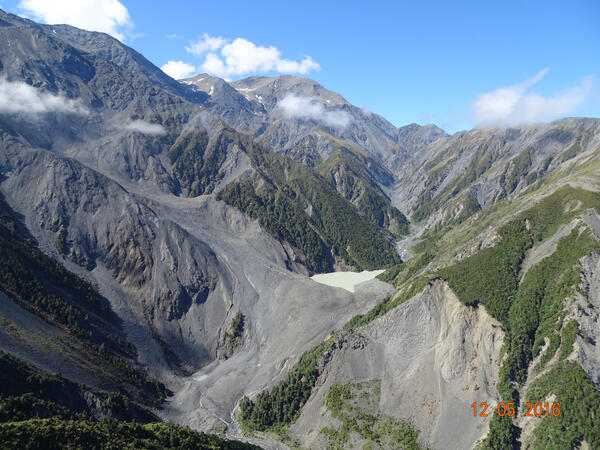
New Zealand Landslides
Photograph showing a landslide-dammed lake in the headwaters of the Hapuku River in the Seaward Kaikoura mountain range in New Zealand.
Photograph showing a landslide-dammed lake in the headwaters of the Hapuku River in the Seaward Kaikoura mountain range in New Zealand.

New Zealand Landslides
Photograph showing landslides covering State Route 1 near Ohau Point. The route was impacted my several landslides and is the main north-south highway on the eastern part of the South Island of New Zealand.
Photograph showing landslides covering State Route 1 near Ohau Point. The route was impacted my several landslides and is the main north-south highway on the eastern part of the South Island of New Zealand.

Newly drilled well with water gushing
Newly drilled well with water gushing
Newly drilled well with water gushing

Nodule from Spor Mountain
Large layered nodule from the Roadside pit, Spor Mountain, Utah, showing fluorite, opal, and bertrandite mineralization. Beryllium is concentrated in the outer opal-fluorite zone; such samples can contain as much as 1-percent beryllium as bertrandite.
Large layered nodule from the Roadside pit, Spor Mountain, Utah, showing fluorite, opal, and bertrandite mineralization. Beryllium is concentrated in the outer opal-fluorite zone; such samples can contain as much as 1-percent beryllium as bertrandite.

Oil Wells in ND
Water is used for many direct aspects of unconventional oil and gas development including drilling, development, and maintenance of wells. (Photograph by Janet Carter, USGS)
Water is used for many direct aspects of unconventional oil and gas development including drilling, development, and maintenance of wells. (Photograph by Janet Carter, USGS)

Perfect Row with USGS Gage-Shane Stocks
This image is of a perfect row in a field with a USGS Gage in the background. The image was taken by Shane Stocks out of the LMG Jackson, MS office.
This image is of a perfect row in a field with a USGS Gage in the background. The image was taken by Shane Stocks out of the LMG Jackson, MS office.

Photographs taken during (left) and after (right) Tropical Storm Colin
Photographs taken during Tropical Storm Colin (left, June 6, 2016) and one day later (right) on Sunset Beach in the town of St. Pete Beach, Florida. Storm waves eroded the beach and dune, producing a cliff-like feature called a beach scarp. Continuous video collected during a storm could provide more information about the processes causing this coastal change.
Photographs taken during Tropical Storm Colin (left, June 6, 2016) and one day later (right) on Sunset Beach in the town of St. Pete Beach, Florida. Storm waves eroded the beach and dune, producing a cliff-like feature called a beach scarp. Continuous video collected during a storm could provide more information about the processes causing this coastal change.

Preparing oceanographic platform in Forsythe NWR, NJ
Neil Ganju (standing) and Patrick Dickhudt preparing an oceanographic platform to measure wetland sediment transport in Forsythe NWR, New Jersey
Neil Ganju (standing) and Patrick Dickhudt preparing an oceanographic platform to measure wetland sediment transport in Forsythe NWR, New Jersey

Pyrite and Quartz
A sample of pyrite and quartz. Iron pyrite, also known as Fool's Gold due to its resemblance to gold, often occurs in quartz veins. Pyrite is an important source of sulfur dioxide, which is primarily used to create sulfuric acid, an important industrial acid.
A sample of pyrite and quartz. Iron pyrite, also known as Fool's Gold due to its resemblance to gold, often occurs in quartz veins. Pyrite is an important source of sulfur dioxide, which is primarily used to create sulfuric acid, an important industrial acid.

Pyrrohtite
Pyrrhotite is an iron sulfide mineral related to iron pyrite, which is one of the minerals known as Fool's Gold. Pyrrhotite, although not one of the Fool's Gold minerals, is sometimes called magnetic pyrite as it is weakly magnetic. It is most valued as a collectors mineral.
Pyrrhotite is an iron sulfide mineral related to iron pyrite, which is one of the minerals known as Fool's Gold. Pyrrhotite, although not one of the Fool's Gold minerals, is sometimes called magnetic pyrite as it is weakly magnetic. It is most valued as a collectors mineral.

Quiver River, Sunflower County, Mississippi
Waterborne resistivity crew conducting a resistivity survey of the Quiver River, Sunflower County, Mississippi. Electrodes on a floating cable are visible behind the boat, which is travelling upstream. Photo by Ben Miller, 2016
Waterborne resistivity crew conducting a resistivity survey of the Quiver River, Sunflower County, Mississippi. Electrodes on a floating cable are visible behind the boat, which is travelling upstream. Photo by Ben Miller, 2016

Raised Black External Tumors on an Adult Brown Bullhead Fish
Raised black external tumors on adult brown bullhead (Ameiurus nebulosus) collected from Lake Memphremagog (Vermont and Canadian Border) were identified as malignant melanoma in a 2014–17 study.
Raised black external tumors on adult brown bullhead (Ameiurus nebulosus) collected from Lake Memphremagog (Vermont and Canadian Border) were identified as malignant melanoma in a 2014–17 study.

Rearing mosquito larvae for species identification
Mosquito larvae being reared to identify species. Samples collected at the Pu‘uhonua O Hōnaunau National Historical Park, Hawai‘i.
Mosquito larvae being reared to identify species. Samples collected at the Pu‘uhonua O Hōnaunau National Historical Park, Hawai‘i.