
Glaciers and Climate Project Active
Mountain glaciers are dynamic reservoirs of frozen water closely coupled to ecosystems and climate. Glacier change in North America has major socioeconomic impacts, including global sea level change, tourism disruption, natural hazard risk, fishery effects, and water resource alteration. Understanding and quantifying precise connections between glaciers and climate is critical to decision makers, land managers, and the public, who are affected by these consequences of glacier change. The USGS Glaciers and Climate Project is aimed at solving complex scientific problems in snow and ice across North America to promote enhanced monitoring, analysis, and prediction of mountain glacier change. Utilizing expertise across USGS, this project combines legacy glacier monitoring with contemporary methods to reveal glacier-climate insight and deliver relevant, actionable science.
Benchmark Glacier Fact Sheet
The U.S. Geological Survey Benchmark Glacier Project combines decades of direct glaciological data with remote sensing data to advance the quantitative understanding of glacier-climate interactions.
Glacier-Climate Connection

The Glacier-Climate Connection geonarrative tells the story of the U.S. Geological Survey Benchmark Glacier Project, one of the longest running studies of glaciers on Earth.
USGS Benchmark Glacier Project

The flagship research effort of the Glaciers and Climate Project is a multi-glacier, decades-long study of glacier-climate response. Since the 1950s, glacier mass-balance measurements have been systematically collected at five benchmark glaciers, beginning with South Cascade (WA) and later including Gulkana, Wolverine and Lemon Creek Glaciers (AK). Sperry Glacier (MT), monitored since 2005, was added to complete the geographically diverse network in 2013.
Results from this monitoring form the longest continuous record of North American glacier mass balance, which capture seasonal and year-to-year variability. These intensively studied glaciers provide insight into the connection between climate and glaciers at multiple scales.
Historic glacier monitoring has involved various mission areas across USGS, but research was unified into one cohesive program in 2019 (O'Neel and others, 2019). Common field methodologies coupled with long-term, consistently analyzed records, are the hallmark of the Benchmark Glacier Project. Such consistency among sites allows glacier records from different climate zones of North America to be directly compared in order to better understand the impacts of mountain glacier change response of glaciers. Four of the glaciers are considered ‘reference’ glaciers in the World Glacier Monitoring Service’s internationally coordinated glacier monitoring network.
The USGS Benchmark Glacier Project also incorporates data collected from spaceborne and airborne platforms, enabling scientists to document three-dimensional glacier change at regional scales. This application of remotely sensed data broadens the project’s scope and relevance to facilitate glacier change projections, which guide sea level and water resource management strategies.

Benchmark Glaciers
Glacier Mass Balance
Research on Other Glaciers

Additional Resources

- Overview
Mountain glaciers are dynamic reservoirs of frozen water closely coupled to ecosystems and climate. Glacier change in North America has major socioeconomic impacts, including global sea level change, tourism disruption, natural hazard risk, fishery effects, and water resource alteration. Understanding and quantifying precise connections between glaciers and climate is critical to decision makers, land managers, and the public, who are affected by these consequences of glacier change. The USGS Glaciers and Climate Project is aimed at solving complex scientific problems in snow and ice across North America to promote enhanced monitoring, analysis, and prediction of mountain glacier change. Utilizing expertise across USGS, this project combines legacy glacier monitoring with contemporary methods to reveal glacier-climate insight and deliver relevant, actionable science.
Benchmark Glacier Fact Sheet
The U.S. Geological Survey Benchmark Glacier Project combines decades of direct glaciological data with remote sensing data to advance the quantitative understanding of glacier-climate interactions.
Glacier-Climate Connection
The Glacier-Climate Connection geonarrative tells the story of the U.S. Geological Survey Benchmark Glacier Project, one of the longest running studies of glaciers on Earth.
USGS Benchmark Glacier Project
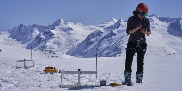
Sources/Usage: Public Domain. View Media DetailsA researcher locates an ablation stake near a crevasse on Wolverine Glacier. These collapsible poles are used to measure snow and ice melt on the glacier surface. The flagship research effort of the Glaciers and Climate Project is a multi-glacier, decades-long study of glacier-climate response. Since the 1950s, glacier mass-balance measurements have been systematically collected at five benchmark glaciers, beginning with South Cascade (WA) and later including Gulkana, Wolverine and Lemon Creek Glaciers (AK). Sperry Glacier (MT), monitored since 2005, was added to complete the geographically diverse network in 2013.
Results from this monitoring form the longest continuous record of North American glacier mass balance, which capture seasonal and year-to-year variability. These intensively studied glaciers provide insight into the connection between climate and glaciers at multiple scales.
Historic glacier monitoring has involved various mission areas across USGS, but research was unified into one cohesive program in 2019 (O'Neel and others, 2019). Common field methodologies coupled with long-term, consistently analyzed records, are the hallmark of the Benchmark Glacier Project. Such consistency among sites allows glacier records from different climate zones of North America to be directly compared in order to better understand the impacts of mountain glacier change response of glaciers. Four of the glaciers are considered ‘reference’ glaciers in the World Glacier Monitoring Service’s internationally coordinated glacier monitoring network.
The USGS Benchmark Glacier Project also incorporates data collected from spaceborne and airborne platforms, enabling scientists to document three-dimensional glacier change at regional scales. This application of remotely sensed data broadens the project’s scope and relevance to facilitate glacier change projections, which guide sea level and water resource management strategies.
Sources/Usage: Public Domain. View Media DetailsLocation of the five USGS Benchmark Glaciers (colored circles) among the glacierized regions of North America (blue). Benchmark Glaciers
Glacier Mass Balance
Research on Other Glaciers
Sources/Usage: Public Domain. View Media DetailsUSGS scientist, Chris McNeil, measures and weighs an ice core extracted from Wolverine Glacier to determine the density of the firn layer. Additional Resources
- Science
- Data
- Publications
- Web Tools
- News
- Partners