
The CMHRP Decadal Science Strategy 2020-2030
This geonarrative constitutes the Decadal Science Strategy of the USGS's Coastal and Marine Hazards and Resources Program for 2020 to 2030.
The Decadal Science Strategy of the Coastal and Marine Hazards and Resources Program (CMHRP) describes the CMHRP's vision and mission and the strategic framework needed to support key program goals: Conduct research and develop science-based tools that lead to safer, more productive coastal communities and improved stewardship of natural resources.
Tips for navigating this Plan
This information explains how to navigate this website so that you get the most out of the experience
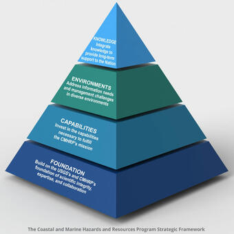
Strategic Framework
The CMHRP uses four overarching approaches to develop our research program
Foundation
The CMHRP's high quality reputation is built on scientific integrity, expertise, and collaboration with partners
Capabilities
CMHRP invests in diverse capabilities to achieve our mission.
Knowledge
The CMHRP creates a bridge between the research community and decision makers
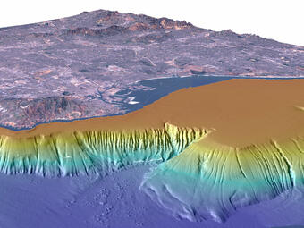
Environments: See where we work


Related Content
Explore examples of our science that are featured in the Plan.

Gas Hydrate and the Environment

Landslide-Induced Tsunamis of Southern Alaska

National Assessment of Coastal Change Hazards

Pacific Coral Reefs

Sediment Mobility Research

Estuarine Ecosystem Recovery in Puget Sound

Ecosystem Restoration in San Francisco Bay and Delta

Gulf Coast Wetland Shoreline Change

Coastal Aquifers

Marine Climate History

Islands

Coral Reefs
Related Content
- Science
Explore examples of our science that are featured in the Plan.
Filter Total Items: 34Gas Hydrate and the Environment
Gas hydrate is an ice-like substance formed when methane or some other gases combine with water at appropriate pressure and temperature conditions. Nearly the entire global inventory of gas hydrates is confined to sediments in a zone tens to hundreds of meters thick close to the seafloor at water depths greater than 350–600 m. On U.S. continental marine margins alone, BOEM estimates that gas...Landslide-Induced Tsunamis of Southern Alaska
Working with partners to study and inform the Nation about geohazard risksNational Assessment of Coastal Change Hazards
The National Assessment of Coastal Change Hazards (NACCH) project develops hindcast, real-time, and forecast assessments of the magnitude or probability of coastal landscape change in response to persistent processes (e.g., shoreline change), extreme storms (e.g., Hurricane Sandy), and sea level rise. This effort depends on parallel collection of long- and short-term observations of coastal change...Pacific Coral Reefs
Coral reefs are unique ecosystems of plants, animals, and their associated geological framework. Although they cover less than 0.5% of Earth's surface, coral reefs are home to an estimated 25% of all marine species. Of the total coral reef habitat in United States waters, about 75%, or more than 16,000 square kilometers (6,000 square miles), is located in the Pacific Ocean.Sediment Mobility Research
Informing Management of the Nearshore and Continental ShelfEstuarine Ecosystem Recovery in Puget Sound
A clean and abundant sediment supply is critical for building and maintaining viable estuarine and wetland habitats. However, in many coastal regions, dikes, levees, and dams have disconnected water and sediment supply to estuarine and wetland habitats, altering sedimentation patterns, water quality, and nutrient loads. Dike and dam removal have become important methods for restoring river and...Ecosystem Restoration in San Francisco Bay and Delta
In many systems, particularly the relatively dry western United States, freshwater that historically flowed into estuaries has been diverted for drinking water, agriculture, and industry. The resulting changes to water flow profoundly altered estuarine ecosystems. CMHRP studies in this complex system inform resource managers tasked with balancing conflicting needs for water and restoration of...Gulf Coast Wetland Shoreline Change
Land and seafloor slopes are generally low along the coasts in the Mid-Atlantic and Gulf Coast states, making wetlands and estuaries vulnerable to sea level change, subsidence, and extreme events (e.g., hurricanes and tropical storms). Land-use change and land loss have been mapped extensively and with increasing frequency, but the link between land loss and the processes responsible for landscape...Coastal Aquifers
Coastal aquifers are groundwater systems that cross land-ocean boundaries. These systems represent a nexus of the world's geologic, hydrologic, and marine systems. Coastal aquifers provide freshwater to more than one billion people who live along the coast and interact with coastal hazards and coastal ecosystems alike. In the twenty-first century, projected climate change and human population...Marine Climate History
Marine climate proxies are geochemical and micropaleontological signatures derived from sediment cores, coral skeletons, and other marine archives. These proxies can be used to reconstruct paleoceanographic parameters, including sea surface and bottom water temperatures, salinity, relative sea level, precipitation patterns, oceanic productivity, and terrestrial inputs to the ocean system.Islands
The CMHRP studies the physical and geological processes that affect islands and their margins. The data that the CMHRP collects are used to document historical and contemporary baseline conditions on islands and to track the impact of short-term ocean events and longer-term sea level rise. This information feeds into forecasts of the islands' future vulnerabilities and provides support for...Coral Reefs
Shallow water (less than ~150 m water depth) coral reefs are seafloor structures built from the calcium carbonate skeletons of marine organisms. Reefs buffer shorelines from waves, storm surges, and tsunamis and help to protect ~200 million of the world's coastal dwellers from flooding, erosion, property damage, and loss of life. Reefs support high levels of biodiversity; they are home to up to 25...