
The CMHRP Decadal Science Strategy 2020-2030
This geonarrative constitutes the Decadal Science Strategy of the USGS's Coastal and Marine Hazards and Resources Program for 2020 to 2030.
The Decadal Science Strategy of the Coastal and Marine Hazards and Resources Program (CMHRP) describes the CMHRP's vision and mission and the strategic framework needed to support key program goals: Conduct research and develop science-based tools that lead to safer, more productive coastal communities and improved stewardship of natural resources.
Tips for navigating this Plan
This information explains how to navigate this website so that you get the most out of the experience
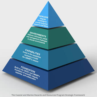
Strategic Framework
The CMHRP uses four overarching approaches to develop our research program
Foundation
The CMHRP's high quality reputation is built on scientific integrity, expertise, and collaboration with partners
Capabilities
CMHRP invests in diverse capabilities to achieve our mission.
Knowledge
The CMHRP creates a bridge between the research community and decision makers
Environments: See where we work


Related Content
Explore examples of our science that are featured in the Plan.

Cape Canaveral Dune Vulnerability-Coastal Process and Hazard

Seafloor Minerals

Gas Hydrate Resources
Sediment Resources

Breton Island National Wildlife Refuge

Use of Lidar in Coastal Studies

Standards, Services, and Science

Communications at the CMHRP

Marine Seismic Imaging

CMHRP Links with Other Mission Areas
Related Content
- Science
Explore examples of our science that are featured in the Plan.
Filter Total Items: 34Cape Canaveral Dune Vulnerability-Coastal Process and Hazard
At Cape Canaveral, located on Florida's east coast, NASA must maintain its space program launch capabilities while protecting sensitive habitat and wildlife populations present within the boundaries of the John F. Kennedy Space Center. Dune erosion due to storms and long-term landward movement of the shoreline (called recession) threaten space program infrastructure, alter habitat, and affect...Seafloor Minerals
The seafloor contains deposits of minerals that we we use in everyday life such as copper, zinc, nickel, gold, silver, and phosphorus. These deposits occur as crusts on volcanic and other rocks and as nodules on abyssal plain sediment that are typically about 3 to 10 centimeters (1 to 4 inches) in diameter.Gas Hydrate Resources
The CMHRP partners with the USGS Energy Resource Program (ERP) in the USGS Energy and Minerals Mission Area in studies of natural gas hydrates . Gas hydrate is a solid, ice-like form of water and gas (usually methane) that is widespread at the intermediate pressure and low temperature conditions that characterize deepwater continental margin sediments and sediments within and beneath continuous...Sediment Resources
Erosion of sandy beaches and barrier islands has resulted in substantial economic (damage to homes and infrastructure) and ecological (loss of habitat for nesting shorebirds and sea turtles) impacts along much of the U.S. coastline. To slow or halt land loss, stakeholders commonly nourish beaches using sand from the continental shelf. Offshore sand and gravel is also mined as aggregate for...Breton Island National Wildlife Refuge
Integrating Mapping and Modeling to Support the Restoration of Bird Nesting HabitatUse of Lidar in Coastal Studies
Since 1998, airborne light detection and ranging, or lidar, capabilities have been developed and utilized to support CMHRP research projects and hazard assessments. Lidar is a remote-sensing technique that measures distance to a target by sending out light energy and detecting how long it takes the reflected pulses to return to the sensor. Lidar data provide information about the elevation, shape...Standards, Services, and Science
Scientists spend considerable time managing the vast amount of data they collect. The volume of scientific data has increased substantially over the past decade due to advances in data collection technology and in the breadth of output produced by models. At the same time, the scientific community has worked to make it easier for the public to obtain data that were once available only by sending a...Communications at the CMHRP
CMHRP science crosses many disciplines and serves a wide range of users, including Federal agencies, Congress, emergency managers, academic institutions, and the general public. Many of these users rely on CMHRP data, tools, maps, and models better understand and manage coastal vulnerabilities, reduce impacts from deep-sea geologic hazards, and improve technologies for creating coastal and...Marine Seismic Imaging
The USGS Coastal/Marine Hazards and Resources Program is a leader in the acquisition, processing, and interpretation of high-resolution seismic data collected in the open ocean, on the continental shelf, and in estuaries, lakes, canals, and rivers. Depending on the scientific target of a survey, the CMHRP uses a variety of acoustic sources (chirp, sparker, boomer, or airguns) to image sediment and...CMHRP Links with Other Mission Areas
Strategy: Coordinate with other USGS Mission Areas and Programs to understand and predict the complex interactions within coastal and marine systems and the environmental and human consequences of natural and human processes. There are several emerging and established opportunities for collaborative prioritization, planning, and program development with other Mission Areas.