Title: ShakeAlert: The Path to West Coast Earthquake Early Warning ... how a few seconds can save lives and property
Videos
 PubTalk 1/2018 — ShakeAlert: Path to West Coast EQ Early Warning
Title: ShakeAlert: The Path to West Coast Earthquake Early Warning ... how a few seconds can save lives and property
A team of USGS scientists spent two weeks in the isolated Glacier Bay National Park, exploring one of the fastest-moving faults in North America.
A team of USGS scientists spent two weeks in the isolated Glacier Bay National Park, exploring one of the fastest-moving faults in North America.
 Excavating the Teton Trench September 2017 - Day 2
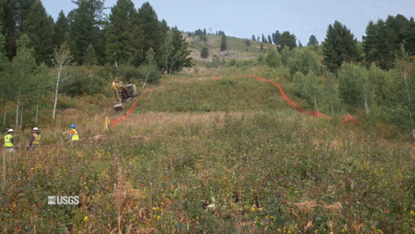
USGS scientists Rich Briggs, Ryan Gold, Chris DuRoss, and Jaime Delano spent September 5-21, 2017 outside of Jackson, Wyoming doing fieldwork at a site to collect paleoseismology data on a segment of the Teton Fault. This video shows the second day of the site excavation inside the flagged the boundaries set up by the group.
USGS scientists Rich Briggs, Ryan Gold, Chris DuRoss, and Jaime Delano spent September 5-21, 2017 outside of Jackson, Wyoming doing fieldwork at a site to collect paleoseismology data on a segment of the Teton Fault. This video shows the second day of the site excavation inside the flagged the boundaries set up by the group.
 Excavating the Teton Trench September 2017 - Day 1
USGS scientists Rich Briggs, Ryan Gold, Chris DuRoss, and Jaime Delano spent September 5-21, 2017 outside of Jackson, Wyoming doing fieldwork at a site to collect paleoseismology data on a segment of the Teton Fault. This video shows the first day of the site excavation inside the flagged the boundaries set up by the group.
USGS scientists Rich Briggs, Ryan Gold, Chris DuRoss, and Jaime Delano spent September 5-21, 2017 outside of Jackson, Wyoming doing fieldwork at a site to collect paleoseismology data on a segment of the Teton Fault. This video shows the first day of the site excavation inside the flagged the boundaries set up by the group.
 PubTalk 5/2017 — Underwater secrets of the Hayward fault zone
Title: Underwater Secrets of the Hayward Fault Zone: Integrated 3D imaging to understand earthquake hazards
Title: Underwater Secrets of the Hayward Fault Zone: Integrated 3D imaging to understand earthquake hazards
 USGS Science in Point Reyes National Seashore (California)
Interviews with staff at Point Reyes National Seashore tell how this National Park Service unit uses USGS science to educate visitors, and manage the park.
Interviews with staff at Point Reyes National Seashore tell how this National Park Service unit uses USGS science to educate visitors, and manage the park.
 Catching the Quakes - Using Seismic Signals to Track Debris Flows
USGS Research Geophysicist Kate Allstadt conducts experiments at the U.S. Geological Survey debris-flow flume, near Eugene, Oregon. Dr. Allstadt and her group are working toward an understanding of how debris flows generate seismic signals.
USGS Research Geophysicist Kate Allstadt conducts experiments at the U.S. Geological Survey debris-flow flume, near Eugene, Oregon. Dr. Allstadt and her group are working toward an understanding of how debris flows generate seismic signals.
 Shaking of Frontier Building — Anchorage, Alaska, During Mw7.1 Earthquake, January 24, 2016
This video presents a visualization of shaking that was recorded in the Frontier Building in Anchorage, Alaska, during the Mw7.1 earthquake, January 24, 2016, Iniskin, Alaska. It exhibits how a tall building behaves and performs during strong earthquake shaking.
This video presents a visualization of shaking that was recorded in the Frontier Building in Anchorage, Alaska, during the Mw7.1 earthquake, January 24, 2016, Iniskin, Alaska. It exhibits how a tall building behaves and performs during strong earthquake shaking.
 Flat Canyon Trench Excavation, Wasatch Fault Zone, Utah
A time-lapse video of the excavation of the trench for a paleoseismology research project at Flat Canyon, Utah, along the Wasatch fault zone.
A time-lapse video of the excavation of the trench for a paleoseismology research project at Flat Canyon, Utah, along the Wasatch fault zone.
Aftershocks are earthquakes that follow the largest shock of an earthquake sequence. They are smaller than the mainshock and within 1-2 fault lengths distance from the mainshock fault. Aftershocks can continue over a period of weeks, months, or years.
Aftershocks are earthquakes that follow the largest shock of an earthquake sequence. They are smaller than the mainshock and within 1-2 fault lengths distance from the mainshock fault. Aftershocks can continue over a period of weeks, months, or years.
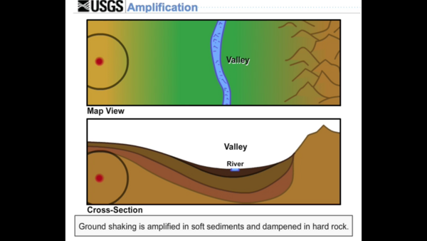
Shaking at a site may be increased, or amplified, by focusing of seismic energy caused by the materials in basins or by surface topography such as mountains.
Shaking at a site may be increased, or amplified, by focusing of seismic energy caused by the materials in basins or by surface topography such as mountains.
An asperity is an area on a fault that is stuck. The earthquake rupture usually begins at an asperity.
An asperity is an area on a fault that is stuck. The earthquake rupture usually begins at an asperity.
When you throw a pebble in a pond, it makes waves on the surface that move out from the place where the pebble entered the water. The waves are largest where they are formed and gradually get smaller as they move away. This decrease in size, or amplitude, of the waves is called attenuation.
When you throw a pebble in a pond, it makes waves on the surface that move out from the place where the pebble entered the water. The waves are largest where they are formed and gradually get smaller as they move away. This decrease in size, or amplitude, of the waves is called attenuation.
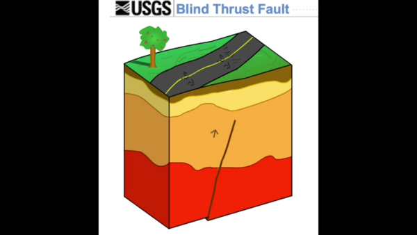
A thrust fault that does not rupture all the way up to the surface so there is no evidence of it on the ground. It is buried under the uppermost layers of rock in the crust.
A thrust fault that does not rupture all the way up to the surface so there is no evidence of it on the ground. It is buried under the uppermost layers of rock in the crust.
Directivity is an effect of a fault rupturing whereby earthquake ground motion in the direction of rupture propagation is more severe than that in other directions from the earthquake source.
Directivity is an effect of a fault rupturing whereby earthquake ground motion in the direction of rupture propagation is more severe than that in other directions from the earthquake source.
A divergent boundary is where two adjacent tectonic plates are moving away from each other.
A divergent boundary is where two adjacent tectonic plates are moving away from each other.
Elastic rebound is what happens to the crustal material on either side of a fault during an earthquake. The idea is that a fault is stuck until the strain accumulated in the rock on either side of the fault has overcome the friction making it stick.
Elastic rebound is what happens to the crustal material on either side of a fault during an earthquake. The idea is that a fault is stuck until the strain accumulated in the rock on either side of the fault has overcome the friction making it stick.
A horst is an upthrown block lying between two steep-angled fault blocks. A graben is a down-dropped block of the earth's crust resulting from extension, or pulling, of the crust.
A horst is an upthrown block lying between two steep-angled fault blocks. A graben is a down-dropped block of the earth's crust resulting from extension, or pulling, of the crust.
Liquefaction is a process by which water-saturated sediment temporarily loses strength and acts like a fluid... like when you wiggle your toes in the wet sand near the water at the beach. This effect can be caused by earthquake shaking.
Liquefaction is a process by which water-saturated sediment temporarily loses strength and acts like a fluid... like when you wiggle your toes in the wet sand near the water at the beach. This effect can be caused by earthquake shaking.
Normal, or Dip-slip, faults are inclined fractures where the blocks have mostly shifted vertically. If the rock mass above an inclined fault moves down, the fault is termed normal, whereas if the rock above the fault moves up, the fault is termed a Reverse fault.
Normal, or Dip-slip, faults are inclined fractures where the blocks have mostly shifted vertically. If the rock mass above an inclined fault moves down, the fault is termed normal, whereas if the rock above the fault moves up, the fault is termed a Reverse fault.
The shadow zone is the area of the earth from angular distances of 104 to 140 degrees that, for a given earthquake, that does not receive any direct P waves. The shadow zone results from S waves (not shown in animation) being stopped entirely by the liquid core and P waves being bent (refracted) by the liquid core.
The shadow zone is the area of the earth from angular distances of 104 to 140 degrees that, for a given earthquake, that does not receive any direct P waves. The shadow zone results from S waves (not shown in animation) being stopped entirely by the liquid core and P waves being bent (refracted) by the liquid core.


