
USGS and Geological Survey of Canada scientists sample sediment cores collected from the sea floor along the Queen Charlotte Fault. This was taken while they were working with (or in) the Geological Survey of Canada.
Images
Browse images from a wide range of science topics covered by USGS.
Filter Total Items: 880

Sampling sea floor sediment cores from along the Queen Charlotte Fault
USGS and Geological Survey of Canada scientists sample sediment cores collected from the sea floor along the Queen Charlotte Fault. This was taken while they were working with (or in) the Geological Survey of Canada.

Walrus Itch
An animated GIF showing a Pacific Walrus scratching/rubbing themselves on their side with their "eye" rolling. The animation repeats in a reverse-motion.
An animated GIF showing a Pacific Walrus scratching/rubbing themselves on their side with their "eye" rolling. The animation repeats in a reverse-motion.

Glacier off Sargent Icefield
Landscape view of an un-named glacier off the Sargent Icefield, directly across from Wolverine Glacier, above the Nellie Juan River, in Alaska. Taken during a visit to a wolverine glacier field site as part of a study to examine how alpine areas are changing as temperatures rise in Alaska.
Landscape view of an un-named glacier off the Sargent Icefield, directly across from Wolverine Glacier, above the Nellie Juan River, in Alaska. Taken during a visit to a wolverine glacier field site as part of a study to examine how alpine areas are changing as temperatures rise in Alaska.

Fish Creek Watershed in the National Petroleum Reserve-Alaska
Fish Creek wanders through the National Petroleum Reserve-Alaska, a 22.8 million acre region managed by the Bureau of Land Management on Alaska's North Slope. USGS has periodically assessed oil and gas resource potential there. These assessments can be found here.
Fish Creek wanders through the National Petroleum Reserve-Alaska, a 22.8 million acre region managed by the Bureau of Land Management on Alaska's North Slope. USGS has periodically assessed oil and gas resource potential there. These assessments can be found here.

Permafrost in the National Petroleum Reserve-Alaska
Permafrost forms a grid-like pattern in the National Petroleum Reserve-Alaska, a 22.8 million acre region managed by the Bureau of Land Management on Alaska's North Slope. USGS has periodically assessed oil and gas resource potential there. These assessments can be found here.
Permafrost forms a grid-like pattern in the National Petroleum Reserve-Alaska, a 22.8 million acre region managed by the Bureau of Land Management on Alaska's North Slope. USGS has periodically assessed oil and gas resource potential there. These assessments can be found here.

Research vessel tracklines offshore of southeast Alaska
Tracklines along which R/V Ocean Starr (2017, red lines) and R/V Norseman (2016, black lines) conducted seismic-reflection surveys, overlaid on high-resolution bathymetry (color background). Yellow stars represent earthquakes of magnitude (M) 7 and greater since 1900.
Tracklines along which R/V Ocean Starr (2017, red lines) and R/V Norseman (2016, black lines) conducted seismic-reflection surveys, overlaid on high-resolution bathymetry (color background). Yellow stars represent earthquakes of magnitude (M) 7 and greater since 1900.

Emperor geese near Kodiak.
Emperor geese gathered near the shoreline on Kodiak Island.
Emperor geese gathered near the shoreline on Kodiak Island.
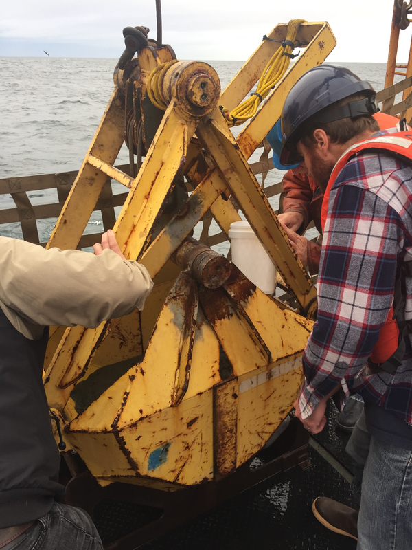
Examining bucket of seafloor sediment collected off southeast Alaska
USGS research geophysicist Danny Brothers (right) and colleagues examine the surface of a sediment grab sample just pulled onto the deck of the Canadian Coast Guard Ship John P. Tully. The sample was collected from the top of a mud volcano north of the border between southeast Alaska and British Columbia.
USGS research geophysicist Danny Brothers (right) and colleagues examine the surface of a sediment grab sample just pulled onto the deck of the Canadian Coast Guard Ship John P. Tully. The sample was collected from the top of a mud volcano north of the border between southeast Alaska and British Columbia.

Sampling core fluid from sediment cores collected off southeast Alaska
Mary McGann (left, USGS) and Rachel Lauer (University of Calgary) sample pore fluids from sediment cores collected aboard the Canadian Coast Guard Ship John P. Tully along the Queen Charlotte-Fairweather fault offshore of southeast Alaska.
Mary McGann (left, USGS) and Rachel Lauer (University of Calgary) sample pore fluids from sediment cores collected aboard the Canadian Coast Guard Ship John P. Tully along the Queen Charlotte-Fairweather fault offshore of southeast Alaska.

Salcha River sonar near Salchaket
Salcha River sonar near Salchaket


Unnamed stream and beaver pond in the Taiya River floodplain
Unnamed stream and beaver pond in the Taiya River floodplain
Unnamed stream and beaver pond in the Taiya River floodplain

Thawing Peatlands, Alaska
Cores were collected from various areas of thawing permafrost-peatlands in Alaska. Permafrost thaw results in ground subsidence and inundation that kills black spruce and other understory plants living on the permafrost plateau.
Cores were collected from various areas of thawing permafrost-peatlands in Alaska. Permafrost thaw results in ground subsidence and inundation that kills black spruce and other understory plants living on the permafrost plateau.

Glacier Creek sonar on a bridge
Glacier Creek sonar

Black-bellied Plover on the mud shore of Big Creek near Egegik, Alaska
Black-bellied Plover on the mud shore of Big Creek, Alaska.
Black-bellied Plover on the mud shore of Big Creek, Alaska.

Pacific Golden-Plover on the shore near Big Creek near Egegik, Alaska
Pacific Golden-Plover on the shore near Big Creek, Alaska.
Pacific Golden-Plover on the shore near Big Creek, Alaska.

Black-legged Kittiwakes in a colony in Cook Inlet, Alaska
Black-legged Kittiwakes in a colony in Cook Inlet, Alaska. One bird on a nest.
Black-legged Kittiwakes in a colony in Cook Inlet, Alaska. One bird on a nest.

Common Murres in their colony in Cook Inlet, Alaska
Common Murres in their colony in Cook Inlet, Alaska
Common Murres in their colony in Cook Inlet, Alaska

Common Murres in a colony in Cook Inlet, Alaska in 2017
Common Murres in a colony in Cook Inlet, Alaska in 2017
Common Murres in a colony in Cook Inlet, Alaska in 2017

The catch from a fyke net set near Kaktovik, Alaska
Biologists identify species, count, measure length, and release thousands of fish each year to understand how fish use nearshore habitats.
Biologists identify species, count, measure length, and release thousands of fish each year to understand how fish use nearshore habitats.

A fyke net set to catch nearshore fish near Kaktovik, Alaska
A fyke net or fish trap used for continuous sampling of nearshore fish in shallow waters. Fish swimming along the beach are stopped by a small-mesh net that guides them in to one of these two underwater fish traps that are set side by side. Researchers visit nets at least once a day to identify, count, and release fish.
A fyke net or fish trap used for continuous sampling of nearshore fish in shallow waters. Fish swimming along the beach are stopped by a small-mesh net that guides them in to one of these two underwater fish traps that are set side by side. Researchers visit nets at least once a day to identify, count, and release fish.