
#WATERACTION sign at the United Nations 2023 Water Conference. Large individual letter sign that states "#wateraction" with New York City skyline in background.
Images
Images intro.
Filter Total Items: 633

#WATERACTION sign at the United Nations 2023 Water Conference
#WATERACTION sign at the United Nations 2023 Water Conference. Large individual letter sign that states "#wateraction" with New York City skyline in background.

United Nations General Assembly
View of participants from behind looking forward in the United Nations general assembly at the United Nations 2023 Water Conference.
View of participants from behind looking forward in the United Nations general assembly at the United Nations 2023 Water Conference.

United Nations Headquarters in New York City
United Nations Headquarters in New York City. View looking up at United Nations headquarters building with flags in foreground.
United Nations Headquarters in New York City. View looking up at United Nations headquarters building with flags in foreground.

Surface water sampling overnight during winter storm in Milwaukee, Wisconsin
Physical Scientist Owen Stefaniak retrieves surface water samples from an autosampler at the upstream Infall site near the Air Guard 128th Air Refueling Wing base during an overnight winter storm.
Physical Scientist Owen Stefaniak retrieves surface water samples from an autosampler at the upstream Infall site near the Air Guard 128th Air Refueling Wing base during an overnight winter storm.

Collecting a surface water grab sample for chloride analysis in winter in Milwaukee, Wisconsin
Physical Scientist Owen Stefaniak collects a surface water grab sample for chloride analysis while a multiparameter sonde takes a water quality measurement near the upstream Infall site near the Air Guard 128th Air Refueling Wing base in Milwaukee, Wisconsin.
Physical Scientist Owen Stefaniak collects a surface water grab sample for chloride analysis while a multiparameter sonde takes a water quality measurement near the upstream Infall site near the Air Guard 128th Air Refueling Wing base in Milwaukee, Wisconsin.

Streamgage station in winter in Milwaukee, Wisconsin
One of four streamgaging stations with autosamplers used in study to detect phosphorus in receiving waters from airport deicer runuff.
One of four streamgaging stations with autosamplers used in study to detect phosphorus in receiving waters from airport deicer runuff.

Remote-controlled ADCP measurement on Wisconsin River at Rainbow Lake near Lake Tomahawk, Wisconsin
linkHydrologic Technician Jarvis Kaderlik makes a stream discharge measurement using a remote-controlled M9 ADCP (acoustic Doppler current profiler) on the Wisconsin River, near streamgage 05391000 Rainbow Lake near Lake Tomahawk, Wisconsin.

Illinois River Basin low-level flight overview
This map shows the airborne geophysical survey area and planned flight paths across the Illinois River Basin in Illinois and northwest Indiana. Surveys will not occur directly above populated areas. Planned flight lines and survey progress can be found online.
(USGS map)
This map shows the airborne geophysical survey area and planned flight paths across the Illinois River Basin in Illinois and northwest Indiana. Surveys will not occur directly above populated areas. Planned flight lines and survey progress can be found online.
(USGS map)

View of downtown Milwaukee, Wisconsin from Pier Wisconsin Cruise dock in winter
View of downtown Milwaukee, Wisconsin from Pier Wisconsin Cruise dock in winter.
View of downtown Milwaukee, Wisconsin from Pier Wisconsin Cruise dock in winter.

View of downtown Milwaukee, Wisconsin at Pier Wisconsin Cruise Dock in winter
View of downtown Milwaukee, Wisconsin from Pier Wisconsin Cruise Dock in winter.
View of downtown Milwaukee, Wisconsin from Pier Wisconsin Cruise Dock in winter.

Invasive annual brome grasses filling in trail.
Invasion by annual brome grasses (cheatgrass and Japanese brome) on a trail across native prairie into National Park Service units in the Northern Great Plains.
Invasion by annual brome grasses (cheatgrass and Japanese brome) on a trail across native prairie into National Park Service units in the Northern Great Plains.

Streamgage 04085074, Dutchman Creek at Cyrus Street near Ashwaubenon, Wisconsin in winter
A snow-covered Streamgage 04085074 with a green USGS sign in front of a red barn on an overcast snowy day at Dutchman Creek at Cyrus Street near Ashwaubenon, Wisconsin.
A snow-covered Streamgage 04085074 with a green USGS sign in front of a red barn on an overcast snowy day at Dutchman Creek at Cyrus Street near Ashwaubenon, Wisconsin.

Measuring stream discharge on an ice-covered Chippewa River, Minnesota
Hydrologic Technician Scott Adolphson takes a discharge measurement of the ice-covered Chippewa River at streamgage 05305000 near Watson, Minnesota surrounded by snow-covered trees.
Hydrologic Technician Scott Adolphson takes a discharge measurement of the ice-covered Chippewa River at streamgage 05305000 near Watson, Minnesota surrounded by snow-covered trees.
Streamgage 04072150 at Duck Creek near Howard, Wisconsin in winter
USGS streamgage 04072150 at Duck Creek near Howard, Wisconsin covered in layer of snow overcast December day.
USGS streamgage 04072150 at Duck Creek near Howard, Wisconsin covered in layer of snow overcast December day.

USGS Mounds View Minnesota office entrance
A snowy entrance to the USGS Mounds View (Twin Cities), Minnesota office in December.
A snowy entrance to the USGS Mounds View (Twin Cities), Minnesota office in December.

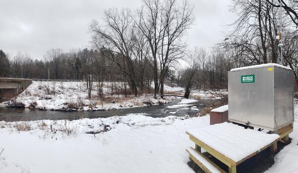
Upstream Infall gaging station near the Air Guard 128th Air Refueling Wing base in Milwaukee, Wisconsin
linkUpstream Infall gaging station near the Air Guard 128th Air Refueling Wing base in Milwaukee, Wisconsin.
Upstream Infall gaging station near the Air Guard 128th Air Refueling Wing base in Milwaukee, Wisconsin
linkUpstream Infall gaging station near the Air Guard 128th Air Refueling Wing base in Milwaukee, Wisconsin.

Streamgage 05291000 Whetstone River near Big Stone City, South Dakota in winter
Streamgage 05291000, Whetstone River near Big Stone City, South Dakota. A green gage house on an elevated platform with a walkway over a shallow bank surrounded by snow-covered foliage during early morning in December.
Streamgage 05291000, Whetstone River near Big Stone City, South Dakota. A green gage house on an elevated platform with a walkway over a shallow bank surrounded by snow-covered foliage during early morning in December.

Streamgage 05049700 Lake Traverse at Reservation Dam near Wheaton, Minnesota in winter
Streamgage 05049700 Lake Traverse at Reservation Dam near Wheaton, Minnesota in winter, surrounded by windswept snow, with a pink-hued snow-covered lake and open water in the background.
Streamgage 05049700 Lake Traverse at Reservation Dam near Wheaton, Minnesota in winter, surrounded by windswept snow, with a pink-hued snow-covered lake and open water in the background.

Acoustic Doppler current profiler floating in middle of Flambeau River near Bruce, Wisconsin on a winter day
linkAn orange acoustic Doppler current profiler (ADCP) floats in the middle of the Flambeau River near Bruce, Wisconsin near USGS streamgage 05360500 on an overcast winter day.
Acoustic Doppler current profiler floating in middle of Flambeau River near Bruce, Wisconsin on a winter day
linkAn orange acoustic Doppler current profiler (ADCP) floats in the middle of the Flambeau River near Bruce, Wisconsin near USGS streamgage 05360500 on an overcast winter day.

A winter landscape in Kewaunee County, Wisconsin
A wintery landscape of snow-covered grass and trees on a late morning in November in Kewaunee County in northeast Wisconsin.
A wintery landscape of snow-covered grass and trees on a late morning in November in Kewaunee County in northeast Wisconsin.

Well water advisory forecast study sample collection door hanger
Kewaunee Wisconsin well water advisory forecast study door hanger left after sample collection.
Kewaunee Wisconsin well water advisory forecast study door hanger left after sample collection.