
Sphaeralcea ambigua, a native plant seeded during RestoreNet experiments, thriving at the Lake Pleasant RestoreNet site in the Sonoran Desert.
Images
Images described and linked on this webpage come from a wide variety of USGS science activities and presentations performed by USGS Science Center staff members in the Region 10: California-Great Basin. A search tool is provided to narrow the number of image files shown.
Filter Total Items: 56

Sphaeralcea ambigua thriving at a Sonoran Desert RestoreNet site
Sphaeralcea ambigua, a native plant seeded during RestoreNet experiments, thriving at the Lake Pleasant RestoreNet site in the Sonoran Desert.

A close up of Sonoran Desert native wildflowers/forbs, including California poppy, lupines, and purple owl's clover
linkClose up of Sonoran Desert flowers, including California poppy, lupines, and purple owl's clover
A close up of Sonoran Desert native wildflowers/forbs, including California poppy, lupines, and purple owl's clover
linkClose up of Sonoran Desert flowers, including California poppy, lupines, and purple owl's clover

Purple owl's clover blooming at a Sonoran Desert RestoreNet site
The RestoreNet plot at McDowell Sonoran Preserve was surrounded by blooming native wildflowers, including purple owl's clover (Castillejia exserta).
The RestoreNet plot at McDowell Sonoran Preserve was surrounded by blooming native wildflowers, including purple owl's clover (Castillejia exserta).

Space Economy Workshop Series
NASA and the United States Geological Survey (USGS) welcome the community to a series of Space Economy Workshops intended to coordinate the development of new technologies to detect and assess off-world mineral resources, as well as to discuss the challenges and opportunities for an off-world mineral resource economy.
NASA and the United States Geological Survey (USGS) welcome the community to a series of Space Economy Workshops intended to coordinate the development of new technologies to detect and assess off-world mineral resources, as well as to discuss the challenges and opportunities for an off-world mineral resource economy.

RestoreNet 2.0 restoration experiment sites with pits with seedballs on Northern Arizona rangelands
linkIn 2022, we piloted RestoreNet V2.0 testing soil inoculation from undegraded reference sites, seed balls (white balls in photo), and pitting treatments (small indentions). Soil inoculation with healthy soils is expected to increase beneficial microbes at the degraded restoration site. Soil microbes can help reduce water stress in plants. Photo by Hannah Farrell.

RestoreNet ConMod with flowers in the Sonoran Desert
Diverse plants growing in a connectivity modified (ConMod) treatment in the Sonoran Desert. Photo by Molly McCormick.
Diverse plants growing in a connectivity modified (ConMod) treatment in the Sonoran Desert. Photo by Molly McCormick.

A collage of images depicts shoreline habitat and wildlife that use the Salton Sea area
A collage of images depicts shoreline habitat and wildlife that use the Salton Sea area in southern California.
A collage of images depicts shoreline habitat and wildlife that use the Salton Sea area in southern California.

Test Platform Sandy the Rover uses BisonCore-Vehicle Formation Programs to follow Engineer around.
linkUAS Research Center BisonCore Project, using onboard autopilot systems, BisonCore on Sandy the Rover instructs the Autopilot to deviate course to follow the UAS Engineer around the parking lot. Acting like a ‘duckling’.

Visualized plot of BisonCore’s Vehicle Formation Programs’ predictive path
UASRC BisonCore Project, using onboard systems inherent to commercial-off-the-shelf (COTS) Autopilots, BisonCore-Vehicle Formation Program predicts the path of the vehicle ahead.
UASRC BisonCore Project, using onboard systems inherent to commercial-off-the-shelf (COTS) Autopilots, BisonCore-Vehicle Formation Program predicts the path of the vehicle ahead.

Didymos Nomenclature
Image showing IAU-approved nomenclature for surface features on asteroid Didymos
Image showing IAU-approved nomenclature for surface features on asteroid Didymos

Dimorphos Nomenclature
Image showing IAU-approved nomenclature for surface features on asteroid Dimophos
Image showing IAU-approved nomenclature for surface features on asteroid Dimophos

USGS and partner engineers with the NASA ER-2 aircraft
Left to Right: Trond Loke (Norsk Elektro Optikk), Isaac Anderson (USGS) and Liz Hyde (USGS) standing in front of the NASA ER-2 aircraft, during deployment to NASA Armstrong Flight Research Center, Palmdale, CA.
Left to Right: Trond Loke (Norsk Elektro Optikk), Isaac Anderson (USGS) and Liz Hyde (USGS) standing in front of the NASA ER-2 aircraft, during deployment to NASA Armstrong Flight Research Center, Palmdale, CA.

First natural color image from the high-altitude HySpex hyperspectral imaging sensor
Natural color image from the first flight of the high-altitude HySpex V-1240. Image is oriented with respect to true North, and is centered around Colombia, CA.
Natural color image from the first flight of the high-altitude HySpex V-1240. Image is oriented with respect to true North, and is centered around Colombia, CA.
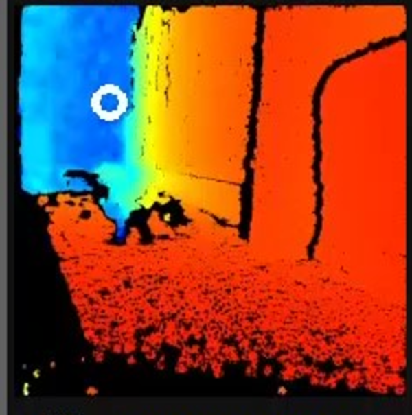
BisonCore Collision Avoidance/GPS Denied Navigation operating in hallway
USGS National Innovation Center UAS Research Center's BisonCore Project, augments an autonomous rover to navigate around obstacles through a hallway, in a GPS Denied Environment. Augmentation done through payload directed operations on data from stereo depth sensors. White circle depicts vehicle’s desired direction.
USGS National Innovation Center UAS Research Center's BisonCore Project, augments an autonomous rover to navigate around obstacles through a hallway, in a GPS Denied Environment. Augmentation done through payload directed operations on data from stereo depth sensors. White circle depicts vehicle’s desired direction.

Mendenhall Fellows Sabine Loos and Max Schneider
In June 2022, Mendenhall Fellow Sabine Loos (Research Civil Engineer in the Geological Hazards Science Center) presented a seminar to USGS's Earthquake Science Center at Moffett Field, CA, where Max Schneider (Research Statistician) works as a Mendenhall Fellow.
In June 2022, Mendenhall Fellow Sabine Loos (Research Civil Engineer in the Geological Hazards Science Center) presented a seminar to USGS's Earthquake Science Center at Moffett Field, CA, where Max Schneider (Research Statistician) works as a Mendenhall Fellow.

Airborne Geophysical Survey Helicopter in Nevada
A low-flying helicopter towing a geophysical device collects scientific data on groundwater and geology. Information collected during these surveys can help with studying critical mineral resources, natural hazards and groundwater potential.
A low-flying helicopter towing a geophysical device collects scientific data on groundwater and geology. Information collected during these surveys can help with studying critical mineral resources, natural hazards and groundwater potential.

Airborne Geophysical Survey Helicopter with Cow
A helicopter rigged with an airborne geophysical survey collecting equipment. Information collected during these surveys can help with studying critical mineral resources, natural hazards and groundwater potential. A cow is here too.
A helicopter rigged with an airborne geophysical survey collecting equipment. Information collected during these surveys can help with studying critical mineral resources, natural hazards and groundwater potential. A cow is here too.

RestoreNet restoration teatments in the Sonoran Desert
RestoreNet treatments include soil pits and connectivity modifiers (ConMods), seen here at a RestoreNet site in the Sonoran Desert.
RestoreNet treatments include soil pits and connectivity modifiers (ConMods), seen here at a RestoreNet site in the Sonoran Desert.

Ruby Lake National Wildlife Reserve
Ruby Lake National Wildlife Refuge lies at the southern end of Ruby Valley in northeast Nevada. For more information visit the Ruby Lake NWR website.
By
Ecosystems, Water Resources, Land Management Research Program, Water Availability and Use Science Program, Forest and Rangeland Ecosystem Science Center, Fort Collins Science Center, Nevada Water Science Center, Oregon Water Science Center, Utah Water Science Center, Western Ecological Research Center (WERC)

Autonomous Augmentation System Test Platform – Sandy the rover with BisonCore installed
UAS Research Center's BisonCore Project, Autonomous Rover Sandy is equipped with a single board companion computer (with BisonCore installed), and various sensors useful for augmentation testing and development.
UAS Research Center's BisonCore Project, Autonomous Rover Sandy is equipped with a single board companion computer (with BisonCore installed), and various sensors useful for augmentation testing and development.
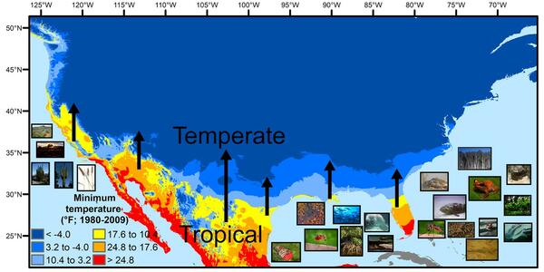
U.S. regions in the tropical-to-temperate transition
A map showing North America's tropical-to-temperate transition zone. Red, orange, and yellow depict the more tropical zones, and blues depict the more temperate zones, based on to the coldest recorded temperature for each area between 1980 and 2009.
A map showing North America's tropical-to-temperate transition zone. Red, orange, and yellow depict the more tropical zones, and blues depict the more temperate zones, based on to the coldest recorded temperature for each area between 1980 and 2009.