


The "From Icefield to Ocean Poster" depicts the important linkages between glaciers and the ocean. The product is a result of Alaska Climate Science Center research projects and workshops.
Ocean and Climate
Marine Climate History
Paleoclimate Research
Ecosystems: EXPRESS
Gas Hydrates Project
The Impact of Sea-Level Rise and Climate Change on the Pacific Ocean
Pacific Island Partnership: Adapting Together
Science Explorer: Climate
The USGS works to understand Earth’s history, past climate conditions, and to forecast climate change impacts. The ocean is an amazing repository for Earth’s climatic history. Earth’s ocean and climate are intrinsically connected and heavily influence one another in many ways. The USGS uses ocean geologic records to better understand current and future climate changes and potential impacts.
Sources/Usage: Public Domain. View Media Details
Changing climate influences many aspects of the ocean, from warming surface waters and altering ocean chemistry to affecting ecosystem function and health. The ocean and its circulation patterns are critical drivers of Earth’s climate and weather patterns.
With the ocean covering more than 70% of the Earth, it plays a large role in controlling the planet’s temperature. The ocean absorbs an enormous amount of heat from the sun—in fact, the top few meters alone store as much heat as the Earth’s atmosphere! As water is very good at storing heat, it spreads the heat around the planet through circulating currents driven by temperature and density differences. These global circulation patterns affect our daily weather and influence long-term climate patterns.
A Changing Ocean
As water heats up, it also expands in volume—a process known as thermal expansion—which causes sea levels to rise. As the Earth warms and cools, the volume of the ocean changes, affecting the volume of ice and land areas covered with ocean or ice. These changes can occur abruptly, such as during transitions from glacial to interglacial conditions, or over long periods of time. Learn more about sea level rise research here.
Changes in water temperatures, salinity and other chemical properties, can alter related circulation patterns. Altogether, these changes can also affect the behavior and physiology of many species by having profound impacts on the timing and availability and timing such as changing food webs, of food, reproduction and migratory patterns. Coral bleaching is one way corals respond to warming sea water temperatures.
The ocean also absorbs gases, which can affect its chemical properties. For example, as carbon dioxide in the atmosphere is absorbed by the ocean, it causes the pH to lower in a process called ocean acidification. Ocean acidification can lead to dissolution of the shells and skeletons of many marine organisms—including economically important shellfish in the seafood industry and ecologically important corals that support biodiversity. It can also dissolve carbonate sediment and alter seafloor elevation and form. USGS monitors the effects of ocean acidification on coastal and marine ecosystems to help inform efforts to mitigate these impacts.

Sources/Usage: Public Domain. View Media Details
USGS Ocean and Climate Research
Ocean science is critical to improving the understanding of Earth's inner workings. From remote-sensing to marine geology and paleoclimate analyses, USGS is an important partner with other federal agencies and international experts working to expand our knowledge about Earth's climate history, especially as related to current conditions. This science improves our ability to understand the factors that affect climate change as well as forecast future climate conditions, their potential impacts and how best to mitigate or adapt to them.
With remote-sensing technology, for example, cameras on satellites can make images of temperature shifts in the open ocean or monitor changes in the formation of sea ice at the poles. Remote-sensing also includes sonar systems on ships, which can be used to create images of the ocean floor and uncover clues about past climatic conditions: USGS researchers studying iceberg tracks, or scours, on the Atlantic seafloor found that during the Last Glacial Period 30,000 years ago, icebergs perhaps as tall as the Eiffel Tower drifted south along the Atlantic coast of North America, ferried along by cold-water currents created during periods of catastrophic glacial melting.
The USGS develops and uses innovative methods to measure climatic and oceanic conditions throughout Earth’s history including sea surface and bottom water temperatures, salinity, relative sea level, precipitation patterns, oceanic productivity, and terrestrial inputs to the ocean system. Data on past climatic conditions in the oceans—the study of geologic records known as paleoceanography—can be combined with data on current conditions to try to predict how our ocean will affect Earth’s future climate patterns.
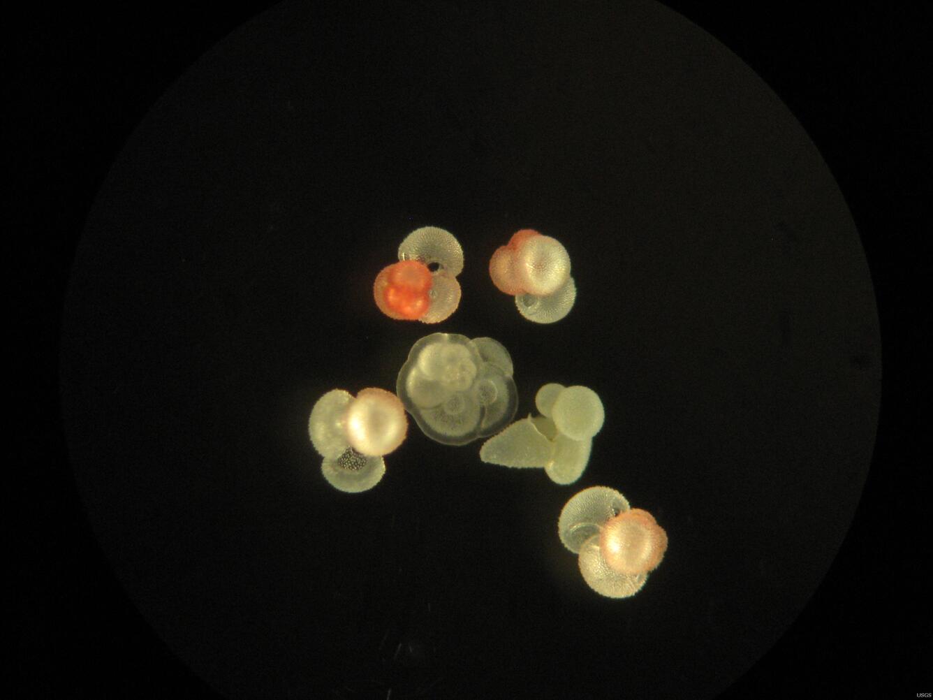
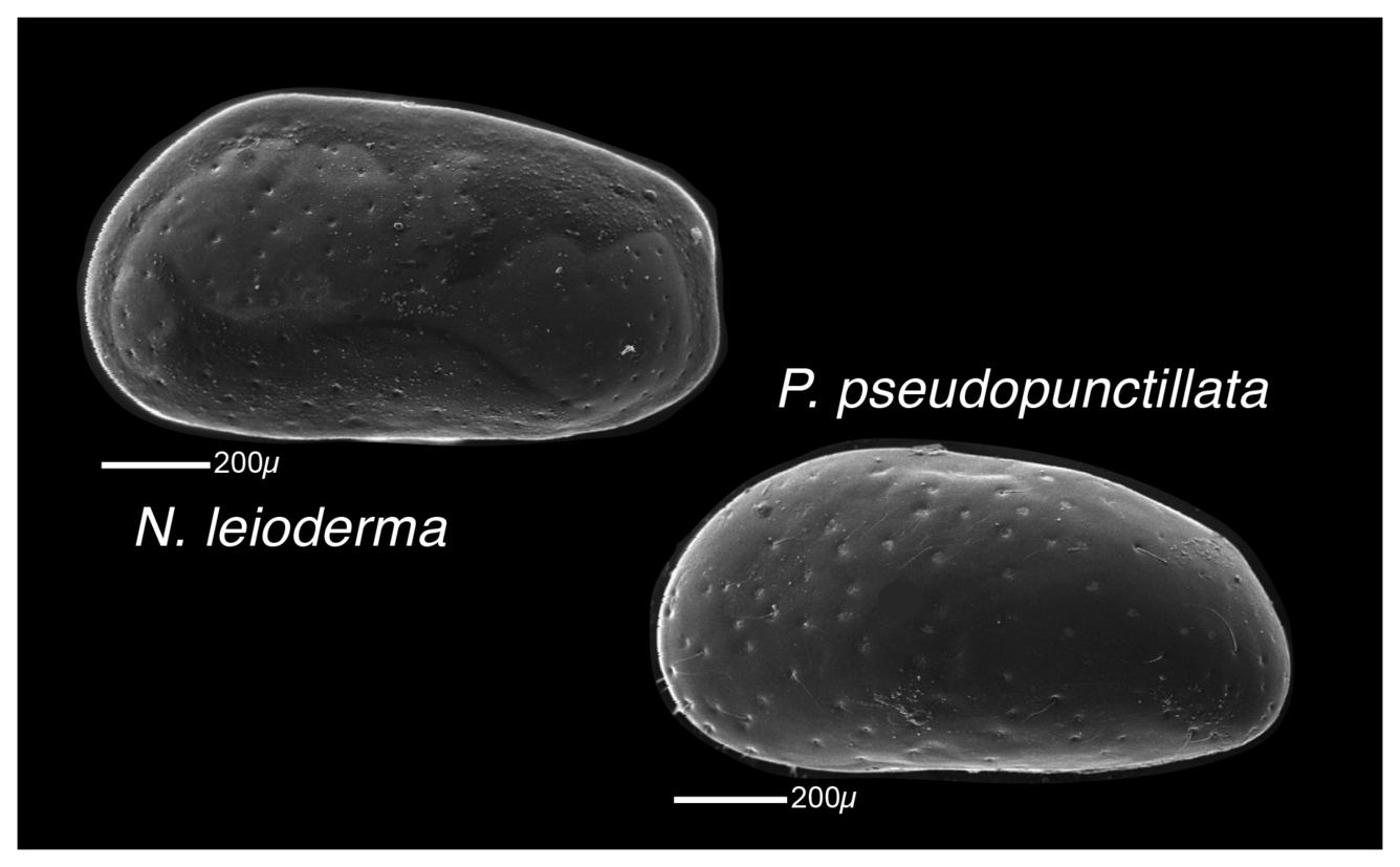
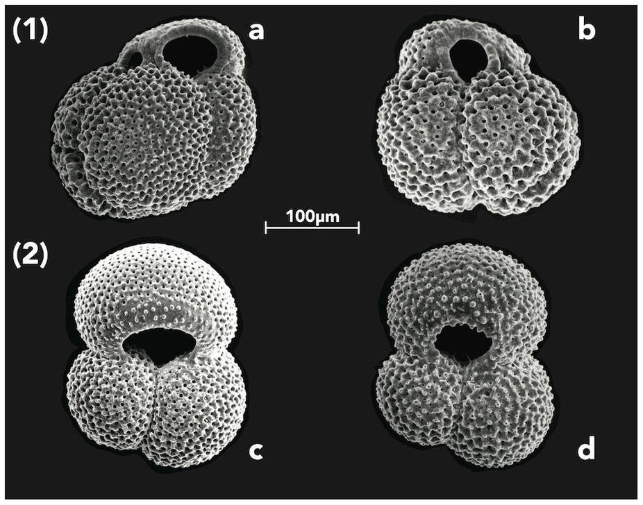
In order to understand the past, USGS scientists analyze “proxies” which serve to indicate past conditions through biological or geological evidence. Some proxies include marine sediment and organisms that secrete their shells from seawater such as plankton, clams, and corals. Proxies for seawater geochemistry reflect the environmental conditions when and where they were formed. These proxies obtained in geologic deposits serve as archives that can be used to reconstruct Earth’s historic conditions so we can better predict what changes might occur in the future.


Sources/Usage: Public Domain. View Media Details
Science
Pacific Islands Climate Adaptation Science Center (PI-CASC): Adapting Together
The Pacific Islands Climate Adaptation Science Center, or PI-CASC (pronounced “pie-cask”), supports regional climate expertise tailored to the unique challenges faced by island communities and ecosystems. PI-CASC serves communities on Hawaiʻi and the U.S.-Affiliated Pacific Islands, supporting resilience and adaptation in the face of climate change.
The Impact of Sea-Level Rise and Climate Change on Pacific Ocean Atolls
Providing basic understanding and specific information on storm-wave inundation of atoll islands that house Department of Defense installations, and assessing the resulting impact of sea-level rise and storm-wave inundation on infrastructure and freshwater availability under a variety of sea-level rise and climatic scenarios.
Paleoclimate Proxies
Paleoclimate proxies are physical, chemical and biological materials preserved within the geologic record (in paleoclimate archives) that can be analyzed and correlated with climate or environmental parameters in the modern world. Scientists combine proxy-based paleoclimate reconstructions with instrumental records (such as thermometer and rain gauge readings) to expand our understanding of...
Paleoclimate Research
Lessons from the Past, Roadmap for the Future The present-day climate of the Earth is influenced by a combination of natural climate variability, increased concentrations of greenhouse gases in the atmosphere since the Industrial Revolution, and changes in land cover (such as conversion from forest to agriculture and back again).
Ecosystems: EXPRESS
The continental shelf and slope offshore California, Oregon, and Washington are home to deep-sea corals, chemosynthetic communities, and other sensitive habitats that could be impacted by the development of energy and mineral resources. The EXPRESS (Expanding Pacific Research and Exploration of Submerged Systems) campaign will map and characterize these special areas to help guide ocean management...
Multimedia

From Icefield to Ocean Poster
The "From Icefield to Ocean Poster" depicts the important linkages between glaciers and the ocean. The product is a result of Alaska Climate Science Center research projects and workshops.

Ridge-to-Reef and Icefield-to-Ocean: Collaborative Research in Extreme Environments
Steep watersheds with dramatic environmental gradients are common features of both the Pacific Islands and Southeast Alaska.
Steep watersheds with dramatic environmental gradients are common features of both the Pacific Islands and Southeast Alaska.

Map of North Atlantic and Gulf Stream
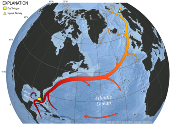
Figure 3. Map of the North Atlantic Ocean illustrating the approximate path of the Gulf Stream / North Atlantic Current system.
Figure 3. Map of the North Atlantic Ocean illustrating the approximate path of the Gulf Stream / North Atlantic Current system.

Adrian Garcia with HyPrCAL laboratory equipment
The USGS Gas Hydrates Project develops and tests new tools to address the critical knowledge gaps identified as scientists analyze hydrate-bearing pressure cores recovered during field programs.
The USGS Gas Hydrates Project develops and tests new tools to address the critical knowledge gaps identified as scientists analyze hydrate-bearing pressure cores recovered during field programs.

HyPrCAL Laboratory
The USGS Gas Hydrates Project manages the standalone Hydrate Pressure Core Analysis Laboratory (HyPrCAL) at the Woods Hole Coastal and Marine Science Center (WHCMSC) to study hydrate-bearing sediments in support of energy resources a
The USGS Gas Hydrates Project manages the standalone Hydrate Pressure Core Analysis Laboratory (HyPrCAL) at the Woods Hole Coastal and Marine Science Center (WHCMSC) to study hydrate-bearing sediments in support of energy resources a

Timing is Everything: Fish, Wildlife, and Timing of Life Events
Timing is Everything: How Fish and Wildlife are Responding to Climate Change Through Shifts in the Timing of Life Events
Timing is Everything: How Fish and Wildlife are Responding to Climate Change Through Shifts in the Timing of Life Events

coral with stony coral tissue loss disease
One of the coral species most susceptible to stony coral tissue loss disease show active lesions of the disease around St. John.
One of the coral species most susceptible to stony coral tissue loss disease show active lesions of the disease around St. John.

Razorbill with Atlantic herring in bill on Seal Island NWR
Razorbill with Atlantic herring in bill on Seal Island National Wildlife Refuge.
Razorbill with Atlantic herring in bill on Seal Island National Wildlife Refuge.

Sediment Cores Reveal the History of the Pacific Ocean
USGS scientist Summer Praetorius of the Geology, Minerals, Energy, & Geophysics (GMEG) Science Center collects samples from an ocean sediment core in the Pacific Ocean Paleoclimatology Lab at Menlo Park, CA. The sediment core is from Tanner Basin, located about 200 miles due west of San Diego in the eastern Pacific Ocean.
USGS scientist Summer Praetorius of the Geology, Minerals, Energy, & Geophysics (GMEG) Science Center collects samples from an ocean sediment core in the Pacific Ocean Paleoclimatology Lab at Menlo Park, CA. The sediment core is from Tanner Basin, located about 200 miles due west of San Diego in the eastern Pacific Ocean.
Filter Total Items: 29

Climate and Environmental Change in the Gulf of Mexico and Caribbean
This project documents paleoceanographic, climatic, and environmental changes in the Gulf of Mexico and adjacent land areas over the last 10,000 years. The paleoenvironmental data is used to determine rates of change in the past, and to better understand both the natural and anthropogenic factors that contribute to climate variability on inter-annual to millennial timescales.

Geologic Records of High Sea Levels
This project studies past high sea levels on coastlines that preserve fossil coral reefs or marine terraces. We ascertain the magnitudes of sea-level high stands by field mapping, stratigraphic measurements, and precise elevation measurements. Geochronology is accomplished by radiocarbon dating of mollusks (for Holocene-to-last-glacial deposits), uranium-series dating of corals (for high-sea...

Coral Bleaching and Disease: Effects on Threatened Corals and Reefs
A severe disease - tentatively named stony coral tissue loss disease - is rapidly killing corals in the U.S. Virgin Islands. Scientists from the U.S. Geological Survey, the University of Puerto Rico, and the National Park Service are working together to better under the disease and determine if the disease affecting corals in the USVI is the same one that has been killing corals in Florida since...

Assessing the Sustainability of Culturally Important Marine Sites in Guam and CNMI
This project was designed to use climate models to produce projections of changes in sea temperatures and ocean chemistry for coastal marine areas in Micronesia as well as reports that describe the outlook of culturally important marine sites in Guam and CNMI. The projections and maps were expected show what the current state of climate science suggests the future holds for marine areas in Microne

Implications of Future Shifts in Migration, Spawning, and Other Life Events of Coastal Fish and Wildlife Species
Climate change is causing species to shift their phenology, or the timing of recurring life events such as migration and spawning, in variable and complex ways. This can potentially result in mismatches or asynchronies in food and habitat resources that negatively impact individual fitness, population dynamics, and ecosystem function. Numerous studies have evaluated phenological shifts in terrestr
- Overview
Sources/Usage: Public Domain. View Media Details
Map of the North Atlantic Ocean illustrating the approximate path of the Gulf Stream / North Atlantic Current system. Also labeled are study sites within the Gulf of Mexico (Dry Tortugas) and Barents Sea (Ingøya, Norway) representing southern and northern endmembers for paleoclimate research targeting reconstruction of Late Holocene surface ocean dynamics. Changing climate influences many aspects of the ocean, from warming surface waters and altering ocean chemistry to affecting ecosystem function and health. The ocean and its circulation patterns are critical drivers of Earth’s climate and weather patterns.
With the ocean covering more than 70% of the Earth, it plays a large role in controlling the planet’s temperature. The ocean absorbs an enormous amount of heat from the sun—in fact, the top few meters alone store as much heat as the Earth’s atmosphere! As water is very good at storing heat, it spreads the heat around the planet through circulating currents driven by temperature and density differences. These global circulation patterns affect our daily weather and influence long-term climate patterns.
A Changing Ocean
As water heats up, it also expands in volume—a process known as thermal expansion—which causes sea levels to rise. As the Earth warms and cools, the volume of the ocean changes, affecting the volume of ice and land areas covered with ocean or ice. These changes can occur abruptly, such as during transitions from glacial to interglacial conditions, or over long periods of time. Learn more about sea level rise research here.
Changes in water temperatures, salinity and other chemical properties, can alter related circulation patterns. Altogether, these changes can also affect the behavior and physiology of many species by having profound impacts on the timing and availability and timing such as changing food webs, of food, reproduction and migratory patterns. Coral bleaching is one way corals respond to warming sea water temperatures.
The ocean also absorbs gases, which can affect its chemical properties. For example, as carbon dioxide in the atmosphere is absorbed by the ocean, it causes the pH to lower in a process called ocean acidification. Ocean acidification can lead to dissolution of the shells and skeletons of many marine organisms—including economically important shellfish in the seafood industry and ecologically important corals that support biodiversity. It can also dissolve carbonate sediment and alter seafloor elevation and form. USGS monitors the effects of ocean acidification on coastal and marine ecosystems to help inform efforts to mitigate these impacts.
Sources/Usage: Public Domain. View Media DetailsThese 3D perspective views of the seafloor offshore of South Carolina show numerous grooves carved by drifting icebergs. As iceberg keels (the portion of the iceberg underwater) plow into the seafloor, they dig deep grooves that push aside boulders and piles of sand and mud along their tracks. Sediment cores from nearby buried iceberg scours, or tracks, were used to determine when these icebergs travelled south along the coast. Credit: Jenna Hill, U.S. Geological Survey, Pacific Coastal and Marine Science Center USGS Ocean and Climate Research
Ocean science is critical to improving the understanding of Earth's inner workings. From remote-sensing to marine geology and paleoclimate analyses, USGS is an important partner with other federal agencies and international experts working to expand our knowledge about Earth's climate history, especially as related to current conditions. This science improves our ability to understand the factors that affect climate change as well as forecast future climate conditions, their potential impacts and how best to mitigate or adapt to them.
With remote-sensing technology, for example, cameras on satellites can make images of temperature shifts in the open ocean or monitor changes in the formation of sea ice at the poles. Remote-sensing also includes sonar systems on ships, which can be used to create images of the ocean floor and uncover clues about past climatic conditions: USGS researchers studying iceberg tracks, or scours, on the Atlantic seafloor found that during the Last Glacial Period 30,000 years ago, icebergs perhaps as tall as the Eiffel Tower drifted south along the Atlantic coast of North America, ferried along by cold-water currents created during periods of catastrophic glacial melting.
The USGS develops and uses innovative methods to measure climatic and oceanic conditions throughout Earth’s history including sea surface and bottom water temperatures, salinity, relative sea level, precipitation patterns, oceanic productivity, and terrestrial inputs to the ocean system. Data on past climatic conditions in the oceans—the study of geologic records known as paleoceanography—can be combined with data on current conditions to try to predict how our ocean will affect Earth’s future climate patterns.
In order to understand the past, USGS scientists analyze “proxies” which serve to indicate past conditions through biological or geological evidence. Some proxies include marine sediment and organisms that secrete their shells from seawater such as plankton, clams, and corals. Proxies for seawater geochemistry reflect the environmental conditions when and where they were formed. These proxies obtained in geologic deposits serve as archives that can be used to reconstruct Earth’s historic conditions so we can better predict what changes might occur in the future.


 Sources/Usage: Public Domain. View Media Details
USGS scientists analyze the geochemistry of proxies—the chemistry of which reflect the environmental conditions where and when they were formed. Some proxies include marine sediment and organisms such as plankton, clams, and corals. These proxies in geologic archives are used to reconstruct Earth’s historic conditions so we can better predict what changes might occur in the future. Science
Pacific Islands Climate Adaptation Science Center (PI-CASC): Adapting Together
The Pacific Islands Climate Adaptation Science Center, or PI-CASC (pronounced “pie-cask”), supports regional climate expertise tailored to the unique challenges faced by island communities and ecosystems. PI-CASC serves communities on Hawaiʻi and the U.S.-Affiliated Pacific Islands, supporting resilience and adaptation in the face of climate change.The Impact of Sea-Level Rise and Climate Change on Pacific Ocean Atolls
Providing basic understanding and specific information on storm-wave inundation of atoll islands that house Department of Defense installations, and assessing the resulting impact of sea-level rise and storm-wave inundation on infrastructure and freshwater availability under a variety of sea-level rise and climatic scenarios.Paleoclimate Proxies
Paleoclimate proxies are physical, chemical and biological materials preserved within the geologic record (in paleoclimate archives) that can be analyzed and correlated with climate or environmental parameters in the modern world. Scientists combine proxy-based paleoclimate reconstructions with instrumental records (such as thermometer and rain gauge readings) to expand our understanding of...Paleoclimate Research
Lessons from the Past, Roadmap for the Future The present-day climate of the Earth is influenced by a combination of natural climate variability, increased concentrations of greenhouse gases in the atmosphere since the Industrial Revolution, and changes in land cover (such as conversion from forest to agriculture and back again).Ecosystems: EXPRESS
The continental shelf and slope offshore California, Oregon, and Washington are home to deep-sea corals, chemosynthetic communities, and other sensitive habitats that could be impacted by the development of energy and mineral resources. The EXPRESS (Expanding Pacific Research and Exploration of Submerged Systems) campaign will map and characterize these special areas to help guide ocean management...Multimedia
From Icefield to Ocean PosterThe "From Icefield to Ocean Poster" depicts the important linkages between glaciers and the ocean. The product is a result of Alaska Climate Science Center research projects and workshops.
The "From Icefield to Ocean Poster" depicts the important linkages between glaciers and the ocean. The product is a result of Alaska Climate Science Center research projects and workshops.
Ridge-to-Reef and Icefield-to-Ocean: Collaborative Research in Extreme EnvironmentsSteep watersheds with dramatic environmental gradients are common features of both the Pacific Islands and Southeast Alaska.
Steep watersheds with dramatic environmental gradients are common features of both the Pacific Islands and Southeast Alaska.
Map of North Atlantic and Gulf StreamFigure 3. Map of the North Atlantic Ocean illustrating the approximate path of the Gulf Stream / North Atlantic Current system.
Figure 3. Map of the North Atlantic Ocean illustrating the approximate path of the Gulf Stream / North Atlantic Current system.
Adrian Garcia with HyPrCAL laboratory equipmentThe USGS Gas Hydrates Project develops and tests new tools to address the critical knowledge gaps identified as scientists analyze hydrate-bearing pressure cores recovered during field programs.
The USGS Gas Hydrates Project develops and tests new tools to address the critical knowledge gaps identified as scientists analyze hydrate-bearing pressure cores recovered during field programs.
HyPrCAL LaboratoryThe USGS Gas Hydrates Project manages the standalone Hydrate Pressure Core Analysis Laboratory (HyPrCAL) at the Woods Hole Coastal and Marine Science Center (WHCMSC) to study hydrate-bearing sediments in support of energy resources a
The USGS Gas Hydrates Project manages the standalone Hydrate Pressure Core Analysis Laboratory (HyPrCAL) at the Woods Hole Coastal and Marine Science Center (WHCMSC) to study hydrate-bearing sediments in support of energy resources a
Timing is Everything: Fish, Wildlife, and Timing of Life EventsTiming is Everything: How Fish and Wildlife are Responding to Climate Change Through Shifts in the Timing of Life Events
Timing is Everything: How Fish and Wildlife are Responding to Climate Change Through Shifts in the Timing of Life Events
coral with stony coral tissue loss diseaseOne of the coral species most susceptible to stony coral tissue loss disease show active lesions of the disease around St. John.
One of the coral species most susceptible to stony coral tissue loss disease show active lesions of the disease around St. John.
Razorbill with Atlantic herring in bill on Seal Island NWRRazorbill with Atlantic herring in bill on Seal Island National Wildlife Refuge.
Razorbill with Atlantic herring in bill on Seal Island National Wildlife Refuge.
Sediment Cores Reveal the History of the Pacific OceanUSGS scientist Summer Praetorius of the Geology, Minerals, Energy, & Geophysics (GMEG) Science Center collects samples from an ocean sediment core in the Pacific Ocean Paleoclimatology Lab at Menlo Park, CA. The sediment core is from Tanner Basin, located about 200 miles due west of San Diego in the eastern Pacific Ocean.
USGS scientist Summer Praetorius of the Geology, Minerals, Energy, & Geophysics (GMEG) Science Center collects samples from an ocean sediment core in the Pacific Ocean Paleoclimatology Lab at Menlo Park, CA. The sediment core is from Tanner Basin, located about 200 miles due west of San Diego in the eastern Pacific Ocean.
- Publications
- Science
Filter Total Items: 29
Climate and Environmental Change in the Gulf of Mexico and Caribbean
This project documents paleoceanographic, climatic, and environmental changes in the Gulf of Mexico and adjacent land areas over the last 10,000 years. The paleoenvironmental data is used to determine rates of change in the past, and to better understand both the natural and anthropogenic factors that contribute to climate variability on inter-annual to millennial timescales.Geologic Records of High Sea Levels
This project studies past high sea levels on coastlines that preserve fossil coral reefs or marine terraces. We ascertain the magnitudes of sea-level high stands by field mapping, stratigraphic measurements, and precise elevation measurements. Geochronology is accomplished by radiocarbon dating of mollusks (for Holocene-to-last-glacial deposits), uranium-series dating of corals (for high-sea...Coral Bleaching and Disease: Effects on Threatened Corals and Reefs
A severe disease - tentatively named stony coral tissue loss disease - is rapidly killing corals in the U.S. Virgin Islands. Scientists from the U.S. Geological Survey, the University of Puerto Rico, and the National Park Service are working together to better under the disease and determine if the disease affecting corals in the USVI is the same one that has been killing corals in Florida since...Assessing the Sustainability of Culturally Important Marine Sites in Guam and CNMI
This project was designed to use climate models to produce projections of changes in sea temperatures and ocean chemistry for coastal marine areas in Micronesia as well as reports that describe the outlook of culturally important marine sites in Guam and CNMI. The projections and maps were expected show what the current state of climate science suggests the future holds for marine areas in MicroneImplications of Future Shifts in Migration, Spawning, and Other Life Events of Coastal Fish and Wildlife Species
Climate change is causing species to shift their phenology, or the timing of recurring life events such as migration and spawning, in variable and complex ways. This can potentially result in mismatches or asynchronies in food and habitat resources that negatively impact individual fitness, population dynamics, and ecosystem function. Numerous studies have evaluated phenological shifts in terrestr - Data and More
- Multimedia
- News
- FAQ