


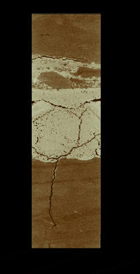
Seafloor features such as sulfide mounds and chimneys are prominent evidence of hydrothermal activity. These features, whether active or dormant, are just the tip of the iceberg, so to speak; much of the “plumbing” of hydrothermal systems exists beneath the seafloor surface.
Ocean Discovery
USGS Leads Research Expedition to Deep-sea Escanaba Trough
Watch short videos about the expedition, and read deep-dive stories about hydrothermal systems, marine geology, and critical minerals.
Watch short videos about the expedition, and read deep-dive stories about hydrothermal systems, marine geology, and critical minerals.
Humans know more about the physical and chemical properties of outer space than about planet Earth’s deep ocean regions. Just like space travel, exploring the often hard-to-reach submarine areas requires innovative approaches and technologies. USGS and partners are driving technology, to explore and discover new ocean environments and habitats that we know very little about.
Exploring the Ocean World
Sources/Usage: Public Domain. View Media Details
The ocean covers more than 70 percent of our planet, yet more than 80 percent of the marine environment remains unexplored and unmapped. This enormous gap in our understanding is narrowing, thanks in part to innovative approaches and techniques and exploration conducted by the USGS and its partners. Like space explorers, USGS deep-sea scientists are motivated by a desire to explore an unknown world, a world that has rarely – if ever – been seen by human eyes.
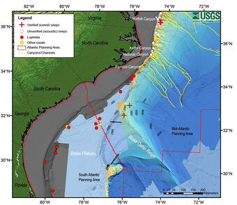
Research vessels or ships designed for scientific research, are small communities of scientists. On board the ship, geologists, biologists, microbiologists, geneticists, geospatial analysts, and engineers travel to the distant parts of the ocean, where they stay and work together, often for weeks at a time. While at sea, the interdisciplinary team weaves together seafloor imagery and maps; collects biological, hydrological, and geological samples; and other types of environmental data to help tell the story of what life is like at the bottom of the ocean. Each expedition brings our scientists face-to-face with something new, and with each discovery of a new deep-sea creature or feature, such as an 86-mile-long coral reef off the coast of Charleston, South Carolina, USGS researchers continue to push scientific limits as they dive deeper into the oceanic frontier.
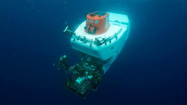
To help explore these hard-to-reach parts of the ocean, USGS scientists use underwater robots like remotely operated vehicles (ROVs), automated underwater vehicles (AUVs), or human occupied vehicles (HOVs). These underwater vehicles let us discover and explore remarkable geological features, as topographically complex as features on land, and deep-sea ecosystems teeming with biodiversity. The USGS works with academic, industry and other private and federal partners to advance our technological capabilities. Learn more about USGS deep sea research.
Sources/Usage: Public Domain. View Media Details
Sources/Usage: Some content may have restrictions. View Media Details
Thanks to these underwater vehicles, USGS scientists can investigate deepwater ecosystems such as hydrothermal vents, canyons, and cold seeps, working to characterize the microbial and benthic communities they support. USGS scientists identify, characterize, and quantify environmental microbial communities, which are critical components of healthy marine ecosystems. They also conduct research to understand community and food web structure, biodiversity, and habitat connectivity of marine benthic ecosystems, which involves examining the small animals that live in or on the seafloor. By providing a baseline understanding of these never-explored habitats, USGS science helps inform issues, such as the management of resource use and energy production.
We know that some of these areas are physically and biologically well-connected to land areas as well as to each other through areas of specialized research. Many explorative research efforts are collaborative and multidisciplinary in nature, developing holistic understanding of the ocean, from geologic structure and hazards, geochemistry and the unique mineralogic and biological communities that have developed in these environments. Scientists believe that life on Earth began more than 3.5 billion years ago in the ocean. The linkages between these remote areas and human populations and activities may not be as far removed as we think.
Innovative Technology
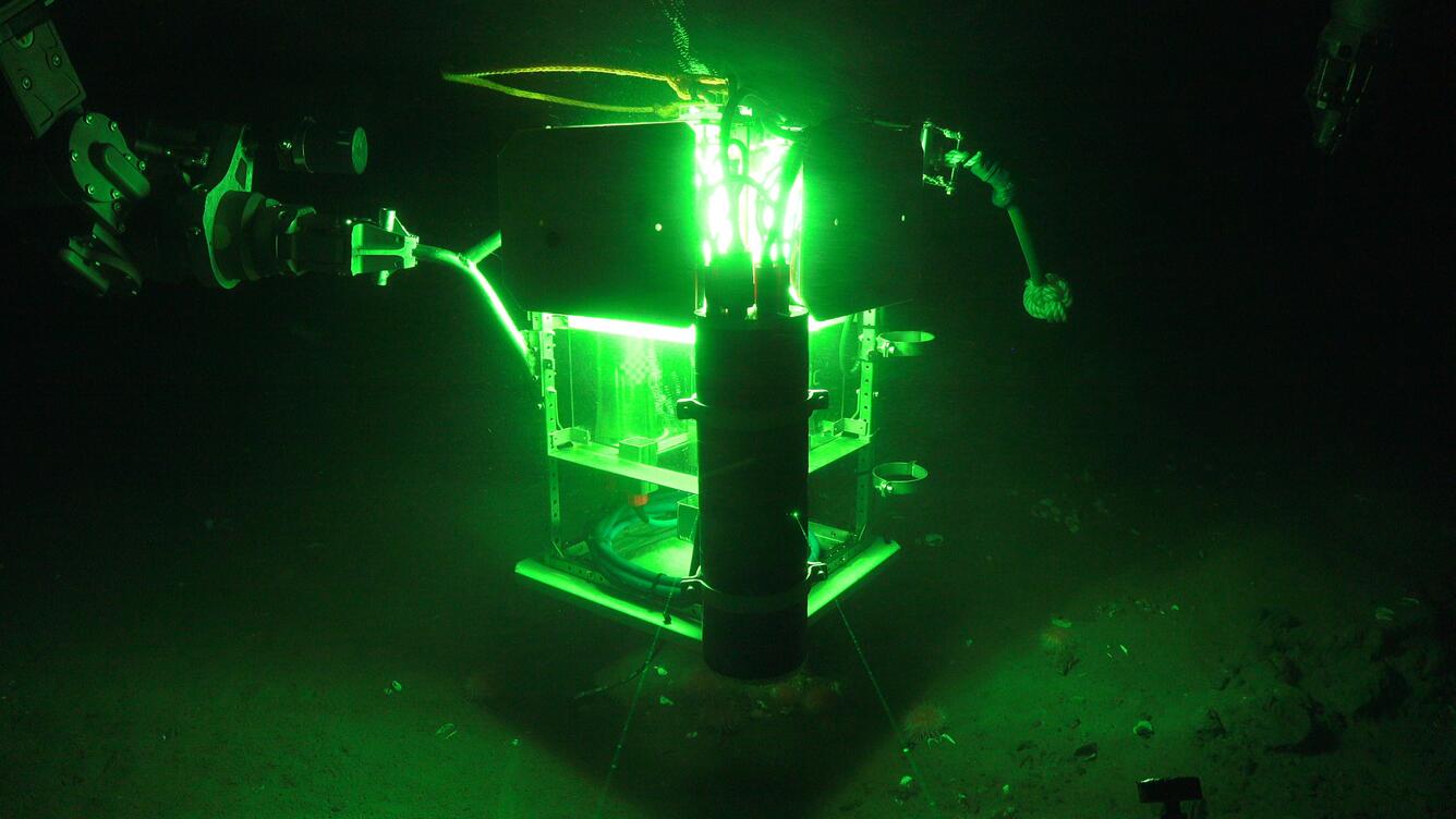
Exploring new places often requires new ways of doing things. New equipment, methods and capabilities are needed to access and study these hard-to-reach these locations, to obtain samples, and to ensure that these samples are preserved so they are useful at land surface. The USGS has worked with many partners to design specific new tools and capabilities so that we can learn as much as we can with each visit to these remote areas. This extensive network has allowed the USGS to tap into innovative technologies, for example, benthic landers for long-term data collection in the Atlantic Ocean and Gulf of Mexico and methane gas bubble collectors in the Pacific Ocean.


Sources/Usage: Public Domain. View Media Details
Science
EXPRESS: Expanding Pacific Research and Exploration of Submerged Systems
EXPRESS is a multi-year, multi-institution cooperative research campaign in deep sea areas of California, Oregon, and Washington, including the continental shelf and slope. EXPRESS data and information are intended to guide wise use of living marine resources and habitats, inform ocean energy and mineral resource decisions, and improve offshore hazard assessments.
By
Coastal and Marine Hazards and Resources Program, Pacific Coastal and Marine Science Center, 3-D CT Core Imaging Laboratory, Core Preparation and Analysis Laboratory and Sample Repositories, Multi-Sensor Core Logger Laboratory, Organic Geochemistry Laboratory, Deep Sea Exploration, Mapping and Characterization
USGS Role in DEEP SEARCH: Deep Sea Exploration to Advance Research on Coral, Canyon, and Cold-seep Habitats
USGS scientists are collaborating with multiple agencies to provide the esssential foundation for understanding these deep-sea environments.
By
Ecosystems Mission Area, Land Management Research Program, Pacific Coastal and Marine Science Center, St. Petersburg Coastal and Marine Science Center, Wetland and Aquatic Research Center , Woods Hole Coastal and Marine Science Center, Deep Sea Exploration, Mapping and Characterization, Gulf of Mexico
DISCOVRE: Diversity, Systematics and Connectivity of Vulnerable Reef Ecosystems
DISCOVRE ( DI versity, S ystematics and CO nnectivity of V ulnerable R eef E cosystems) is an integrated, multidisciplinary, international effort investigating the unique and fragile deep-sea coral environments from the microscopic level to the ecosystem level.
U.S. Geological Survey Gas Hydrates Project
The USGS Gas Hydrates Project has been making contributions to advance understanding of US and international gas hydrates science for at least three decades. The research group working on gas hydrates at the USGS is among the largest in the US and has expertise in all the major geoscience disciplines, as well as in the physics and chemistry of gas hydrates, the geotechnical properties of hydrate...
The Mid-Atlantic Resource Imaging Experiment (MATRIX)
In late August 2018, scientists and technical staff from the USGS Coastal and Marine Hazards and Resources Program completed the acquisition of over 2000 km of multichannel seismic (MCS) data as part of the Mid-Atlantic Resource Imaging Experiment (MATRIX) conducted aboard the R/V Hugh R. Sharp . The seismic program was led by the USGS Gas Hydrates Project and was sponsored by the USGS, the U.S...
Multimedia

Escanaba Trough Expedition: Gravity Coring
Seafloor features such as sulfide mounds and chimneys are prominent evidence of hydrothermal activity. These features, whether active or dormant, are just the tip of the iceberg, so to speak; much of the “plumbing” of hydrothermal systems exists beneath the seafloor surface.

Escanaba Trough Expedition: Part 2
Critical to scientific operations aboard the Escanaba Trough expedition is the submersible robots Sentry and Jason. Owned and operated by the Woods Hole Oceanographic Institute (WHOI), these robots allow researchers to observe seafloor features and collect data from depths seldom visited by humans.
Critical to scientific operations aboard the Escanaba Trough expedition is the submersible robots Sentry and Jason. Owned and operated by the Woods Hole Oceanographic Institute (WHOI), these robots allow researchers to observe seafloor features and collect data from depths seldom visited by humans.

Escanaba Trough Expedition: Part 3
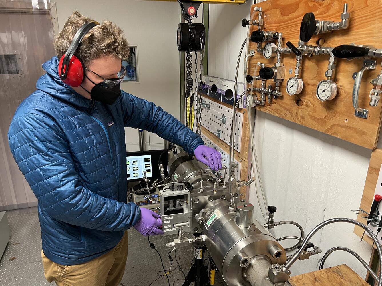
For scientists aboard the Escanaba Trough expedition, obtaining sediment cores or deep-sea biological and geological samples after a Jason dive is only the beginning.
For scientists aboard the Escanaba Trough expedition, obtaining sediment cores or deep-sea biological and geological samples after a Jason dive is only the beginning.

Escanaba Trough Expedition: Introduction
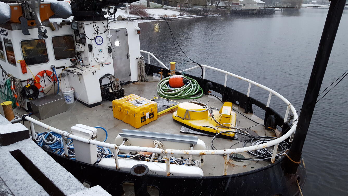
Embarking on a three-week deep-sea research expedition requires a lot of preparation. For this expedition to Escanaba Trough, U.S. Geological Survey scientists and partners spend the first few days in port, building their laboratory space aboard the research vessel Thomas G. Thompson.
Embarking on a three-week deep-sea research expedition requires a lot of preparation. For this expedition to Escanaba Trough, U.S. Geological Survey scientists and partners spend the first few days in port, building their laboratory space aboard the research vessel Thomas G. Thompson.

Iceberg scours on the seafloor
These 3D perspective views of the seafloor bathymetry from multibeam sonar offshore of South Carolina show numerous grooves carved by drifting icebergs. As iceberg keels plow into the seafloor, they dig deep grooves that push aside boulders and piles of sand and mud along their tracks.
These 3D perspective views of the seafloor bathymetry from multibeam sonar offshore of South Carolina show numerous grooves carved by drifting icebergs. As iceberg keels plow into the seafloor, they dig deep grooves that push aside boulders and piles of sand and mud along their tracks.

ROV Deep Discoverer surveying boulder covered in bamboo coral
Remotely operated vehicle Deep Discoverer surveys a large boulder covered in bamboo corals during the 2021 North Atlantic Stepping Stones expedition. Bamboo corals were locally abundant on these large boulders and more spread out throughout different hard-bottom habitats.
Remotely operated vehicle Deep Discoverer surveys a large boulder covered in bamboo corals during the 2021 North Atlantic Stepping Stones expedition. Bamboo corals were locally abundant on these large boulders and more spread out throughout different hard-bottom habitats.

Amanda Demopoulos Unloading ROV SuBastian
USGS scientist Amanda Demopoulos, lead scientist for this expedition, unloads several push cores taken from the sediment at the ocean floor by ROV SuBastian.
By
Ecosystems, Natural Hazards, Coastal and Marine Hazards and Resources Program, Environments Program, Pacific Coastal and Marine Science Center, St. Petersburg Coastal and Marine Science Center, Wetland and Aquatic Research Center , Woods Hole Coastal and Marine Science Center, Communications and Publishing

UNC Lander on the Seafloor
ROV SuBastian arrives at the landing site of one of the UNC landers. The ROV will reposition the lander so it is nearer to a methane seep so it can begin its experiment.
By
Ecosystems, Natural Hazards, Coastal and Marine Hazards and Resources Program, Environments Program, Pacific Coastal and Marine Science Center, St. Petersburg Coastal and Marine Science Center, Wetland and Aquatic Research Center , Woods Hole Coastal and Marine Science Center, Communications and Publishing

Unloading the ROV
USGS scientist Amanda Demopoulos, lead scientist on this cruise, helps unload the collections from a Grays Canyon dive by ROV SuBastian.
By
Ecosystems, Natural Hazards, Coastal and Marine Hazards and Resources Program, Environments Program, Pacific Coastal and Marine Science Center, St. Petersburg Coastal and Marine Science Center, Wetland and Aquatic Research Center , Woods Hole Coastal and Marine Science Center, Communications and Publishing
- Overview
Exploring the Ocean World
Sources/Usage: Public Domain. View Media DetailsDEEP SEARCH Mission operating area. The ocean covers more than 70 percent of our planet, yet more than 80 percent of the marine environment remains unexplored and unmapped. This enormous gap in our understanding is narrowing, thanks in part to innovative approaches and techniques and exploration conducted by the USGS and its partners. Like space explorers, USGS deep-sea scientists are motivated by a desire to explore an unknown world, a world that has rarely – if ever – been seen by human eyes.
Research vessels or ships designed for scientific research, are small communities of scientists. On board the ship, geologists, biologists, microbiologists, geneticists, geospatial analysts, and engineers travel to the distant parts of the ocean, where they stay and work together, often for weeks at a time. While at sea, the interdisciplinary team weaves together seafloor imagery and maps; collects biological, hydrological, and geological samples; and other types of environmental data to help tell the story of what life is like at the bottom of the ocean. Each expedition brings our scientists face-to-face with something new, and with each discovery of a new deep-sea creature or feature, such as an 86-mile-long coral reef off the coast of Charleston, South Carolina, USGS researchers continue to push scientific limits as they dive deeper into the oceanic frontier.
To help explore these hard-to-reach parts of the ocean, USGS scientists use underwater robots like remotely operated vehicles (ROVs), automated underwater vehicles (AUVs), or human occupied vehicles (HOVs). These underwater vehicles let us discover and explore remarkable geological features, as topographically complex as features on land, and deep-sea ecosystems teeming with biodiversity. The USGS works with academic, industry and other private and federal partners to advance our technological capabilities. Learn more about USGS deep sea research.
Sources/Usage: Public Domain. View Media DetailsHuman occupied vehicle (HOV) Alvin descends to the seafloor. Learn more
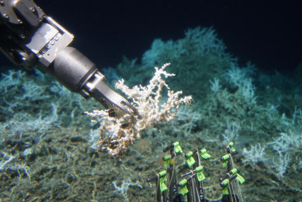
Sources/Usage: Some content may have restrictions. View Media DetailsHOV Alvin collecting a sample of live Lophelia pertusa on the DEEP SEARCH 2018 mission. Learn more Thanks to these underwater vehicles, USGS scientists can investigate deepwater ecosystems such as hydrothermal vents, canyons, and cold seeps, working to characterize the microbial and benthic communities they support. USGS scientists identify, characterize, and quantify environmental microbial communities, which are critical components of healthy marine ecosystems. They also conduct research to understand community and food web structure, biodiversity, and habitat connectivity of marine benthic ecosystems, which involves examining the small animals that live in or on the seafloor. By providing a baseline understanding of these never-explored habitats, USGS science helps inform issues, such as the management of resource use and energy production.
We know that some of these areas are physically and biologically well-connected to land areas as well as to each other through areas of specialized research. Many explorative research efforts are collaborative and multidisciplinary in nature, developing holistic understanding of the ocean, from geologic structure and hazards, geochemistry and the unique mineralogic and biological communities that have developed in these environments. Scientists believe that life on Earth began more than 3.5 billion years ago in the ocean. The linkages between these remote areas and human populations and activities may not be as far removed as we think.
Innovative Technology
Exploring new places often requires new ways of doing things. New equipment, methods and capabilities are needed to access and study these hard-to-reach these locations, to obtain samples, and to ensure that these samples are preserved so they are useful at land surface. The USGS has worked with many partners to design specific new tools and capabilities so that we can learn as much as we can with each visit to these remote areas. This extensive network has allowed the USGS to tap into innovative technologies, for example, benthic landers for long-term data collection in the Atlantic Ocean and Gulf of Mexico and methane gas bubble collectors in the Pacific Ocean.


 Sources/Usage: Public Domain. View Media Details
Science
EXPRESS: Expanding Pacific Research and Exploration of Submerged Systems
EXPRESS is a multi-year, multi-institution cooperative research campaign in deep sea areas of California, Oregon, and Washington, including the continental shelf and slope. EXPRESS data and information are intended to guide wise use of living marine resources and habitats, inform ocean energy and mineral resource decisions, and improve offshore hazard assessments.ByCoastal and Marine Hazards and Resources Program, Pacific Coastal and Marine Science Center, 3-D CT Core Imaging Laboratory, Core Preparation and Analysis Laboratory and Sample Repositories, Multi-Sensor Core Logger Laboratory, Organic Geochemistry Laboratory, Deep Sea Exploration, Mapping and CharacterizationUSGS Role in DEEP SEARCH: Deep Sea Exploration to Advance Research on Coral, Canyon, and Cold-seep Habitats
USGS scientists are collaborating with multiple agencies to provide the esssential foundation for understanding these deep-sea environments.ByEcosystems Mission Area, Land Management Research Program, Pacific Coastal and Marine Science Center, St. Petersburg Coastal and Marine Science Center, Wetland and Aquatic Research Center , Woods Hole Coastal and Marine Science Center, Deep Sea Exploration, Mapping and Characterization, Gulf of MexicoDISCOVRE: Diversity, Systematics and Connectivity of Vulnerable Reef Ecosystems
DISCOVRE ( DI versity, S ystematics and CO nnectivity of V ulnerable R eef E cosystems) is an integrated, multidisciplinary, international effort investigating the unique and fragile deep-sea coral environments from the microscopic level to the ecosystem level.U.S. Geological Survey Gas Hydrates Project
The USGS Gas Hydrates Project has been making contributions to advance understanding of US and international gas hydrates science for at least three decades. The research group working on gas hydrates at the USGS is among the largest in the US and has expertise in all the major geoscience disciplines, as well as in the physics and chemistry of gas hydrates, the geotechnical properties of hydrate...The Mid-Atlantic Resource Imaging Experiment (MATRIX)
In late August 2018, scientists and technical staff from the USGS Coastal and Marine Hazards and Resources Program completed the acquisition of over 2000 km of multichannel seismic (MCS) data as part of the Mid-Atlantic Resource Imaging Experiment (MATRIX) conducted aboard the R/V Hugh R. Sharp . The seismic program was led by the USGS Gas Hydrates Project and was sponsored by the USGS, the U.S...Multimedia
Escanaba Trough Expedition: Gravity CoringSeafloor features such as sulfide mounds and chimneys are prominent evidence of hydrothermal activity. These features, whether active or dormant, are just the tip of the iceberg, so to speak; much of the “plumbing” of hydrothermal systems exists beneath the seafloor surface.
Seafloor features such as sulfide mounds and chimneys are prominent evidence of hydrothermal activity. These features, whether active or dormant, are just the tip of the iceberg, so to speak; much of the “plumbing” of hydrothermal systems exists beneath the seafloor surface.
Escanaba Trough Expedition: Part 2Critical to scientific operations aboard the Escanaba Trough expedition is the submersible robots Sentry and Jason. Owned and operated by the Woods Hole Oceanographic Institute (WHOI), these robots allow researchers to observe seafloor features and collect data from depths seldom visited by humans.
Critical to scientific operations aboard the Escanaba Trough expedition is the submersible robots Sentry and Jason. Owned and operated by the Woods Hole Oceanographic Institute (WHOI), these robots allow researchers to observe seafloor features and collect data from depths seldom visited by humans.
Escanaba Trough Expedition: Part 3For scientists aboard the Escanaba Trough expedition, obtaining sediment cores or deep-sea biological and geological samples after a Jason dive is only the beginning.
For scientists aboard the Escanaba Trough expedition, obtaining sediment cores or deep-sea biological and geological samples after a Jason dive is only the beginning.
Escanaba Trough Expedition: IntroductionEmbarking on a three-week deep-sea research expedition requires a lot of preparation. For this expedition to Escanaba Trough, U.S. Geological Survey scientists and partners spend the first few days in port, building their laboratory space aboard the research vessel Thomas G. Thompson.
Embarking on a three-week deep-sea research expedition requires a lot of preparation. For this expedition to Escanaba Trough, U.S. Geological Survey scientists and partners spend the first few days in port, building their laboratory space aboard the research vessel Thomas G. Thompson.
Iceberg scours on the seafloorThese 3D perspective views of the seafloor bathymetry from multibeam sonar offshore of South Carolina show numerous grooves carved by drifting icebergs. As iceberg keels plow into the seafloor, they dig deep grooves that push aside boulders and piles of sand and mud along their tracks.
These 3D perspective views of the seafloor bathymetry from multibeam sonar offshore of South Carolina show numerous grooves carved by drifting icebergs. As iceberg keels plow into the seafloor, they dig deep grooves that push aside boulders and piles of sand and mud along their tracks.
ROV Deep Discoverer surveying boulder covered in bamboo coralRemotely operated vehicle Deep Discoverer surveys a large boulder covered in bamboo corals during the 2021 North Atlantic Stepping Stones expedition. Bamboo corals were locally abundant on these large boulders and more spread out throughout different hard-bottom habitats.
Remotely operated vehicle Deep Discoverer surveys a large boulder covered in bamboo corals during the 2021 North Atlantic Stepping Stones expedition. Bamboo corals were locally abundant on these large boulders and more spread out throughout different hard-bottom habitats.
Amanda Demopoulos Unloading ROV SuBastianUSGS scientist Amanda Demopoulos, lead scientist for this expedition, unloads several push cores taken from the sediment at the ocean floor by ROV SuBastian.
ByEcosystems, Natural Hazards, Coastal and Marine Hazards and Resources Program, Environments Program, Pacific Coastal and Marine Science Center, St. Petersburg Coastal and Marine Science Center, Wetland and Aquatic Research Center , Woods Hole Coastal and Marine Science Center, Communications and PublishingUSGS scientist Amanda Demopoulos, lead scientist for this expedition, unloads several push cores taken from the sediment at the ocean floor by ROV SuBastian.
ByEcosystems, Natural Hazards, Coastal and Marine Hazards and Resources Program, Environments Program, Pacific Coastal and Marine Science Center, St. Petersburg Coastal and Marine Science Center, Wetland and Aquatic Research Center , Woods Hole Coastal and Marine Science Center, Communications and Publishing
UNC Lander on the SeafloorROV SuBastian arrives at the landing site of one of the UNC landers. The ROV will reposition the lander so it is nearer to a methane seep so it can begin its experiment.
ByEcosystems, Natural Hazards, Coastal and Marine Hazards and Resources Program, Environments Program, Pacific Coastal and Marine Science Center, St. Petersburg Coastal and Marine Science Center, Wetland and Aquatic Research Center , Woods Hole Coastal and Marine Science Center, Communications and PublishingROV SuBastian arrives at the landing site of one of the UNC landers. The ROV will reposition the lander so it is nearer to a methane seep so it can begin its experiment.
ByEcosystems, Natural Hazards, Coastal and Marine Hazards and Resources Program, Environments Program, Pacific Coastal and Marine Science Center, St. Petersburg Coastal and Marine Science Center, Wetland and Aquatic Research Center , Woods Hole Coastal and Marine Science Center, Communications and Publishing
Unloading the ROVUSGS scientist Amanda Demopoulos, lead scientist on this cruise, helps unload the collections from a Grays Canyon dive by ROV SuBastian.
ByEcosystems, Natural Hazards, Coastal and Marine Hazards and Resources Program, Environments Program, Pacific Coastal and Marine Science Center, St. Petersburg Coastal and Marine Science Center, Wetland and Aquatic Research Center , Woods Hole Coastal and Marine Science Center, Communications and PublishingUSGS scientist Amanda Demopoulos, lead scientist on this cruise, helps unload the collections from a Grays Canyon dive by ROV SuBastian.
ByEcosystems, Natural Hazards, Coastal and Marine Hazards and Resources Program, Environments Program, Pacific Coastal and Marine Science Center, St. Petersburg Coastal and Marine Science Center, Wetland and Aquatic Research Center , Woods Hole Coastal and Marine Science Center, Communications and Publishing - Publications
- Science
- Data and More
- Multimedia
- News