


USGS research geologist Curt Storlazzi installs an instrument package on the seafloor of Maunalua Bay, Oʻahu. The platform, called a MiniPROBE, hosts six upward-looking acoustic Doppler current profilers (ADCP), seven conductivity and temperature (CT) sensors, and eight self-logging optical backscatter sensors (SLOBS).
Curt Storlazzi, PhD
My interests span the coastal zone, from seacliff erosional processes to sediment dynamics in the shallow coastal ocean. My research focuses on the quantitative study of hydrodynamics, sediment transport, and geomorphology in coastal and marine environments.
Research Topics
Coral reef morphology, hydrodynamics, and sediment, nutrient, contaminant, and larval transport
The role of coral reefs and other coastal ecosystems in coastal hazard risk reduction
The interplay between geologic structure, climatic fluctuations, and coastal processes
High-resolution oceanographic instrumentation and coastal mapping techniques
The influence of physical processes on coral reef ecosystems
Many tropical coastal environments have been impacted by infrastructure development, nutrient and contaminant delivery, and natural and human-induced sedimentation. The high geomorphic and hydrodynamic complexity both within and between coral reefs, in conjunction with past technical restrictions, has limited our understanding of the nature of flow and the resulting flux of physical, chemical, and biologic material in these ecosystems. Understanding the physical controls on the timing and magnitude of flow and sediment, larvae, nutrient, and contaminant transport, along with their impact on seafloor geomorphology, stability, and sedimentation in these refugia are essential to assessing modern anthropogenic impacts (climate change, etc.) on these ecosystems and help guide how restoration can increase the resiliency of coral reef-lined coastal communities.
See: Coral Reef Project and The Value of U.S. Coral Reefs for Risk Reduction (links below)
The influence of climate change and sea-level rise on coral reef-lined coasts
Observations show that sea level is rising and recent projections indicate sea level will exceed 1.0 m, and may reach 2.0 m, above 2000 levels by the end of the 21st century. The amount of land and water available for human habitation, water and food sources, and ecosystems along coral reef-lined coasts is limited and vulnerable to wave-driven flooding during storms. Rising sea levels will further exacerbate the impacts of storms on coral reef-lined coasts by reducing wave breaking (and thus energy dissipation) over reefs and result in greater wave energy impacting the shoreline, causing increased flooding and changes to the coast such as erosion. Understanding the physical controls on the timing and magnitude of flooding, along with their impact on coastal geomorphology, are essential to assessing impacts on, and the future sustainability of, coastal infrastructure, agriculture, freshwater availability, and ecosystems.
See: Low-lying areas of tropical Pacific islands (links below)
Science and Products
Filter Total Items: 26
Quantifying Flood Risk and Reef Risk Reduction Benefits in Florida and Puerto Rico: The Consequences of Hurricane Damage, Long-term Degradation, and Restoration Opportunities
Coastal flooding and erosion from extreme weather events affect thousands of vulnerable coastal communities; the impacts of coastal flooding are predicted to worsen during this century because of population growth and climate change. Hurricanes Irma and Maria in 2017 were particularly devasting to humans and natural communities. The coral reefs off the State of Florida and the Commonwealth of...
The Value of U.S. Coral Reefs for Risk Reduction
Summary of the report, “Rigorously valuing the role of U.S. coral reefs in coastal hazard risk reduction”
Coral Reef Project: Kauaʻi
As part of the USGS Coral Reef Project, the USGS is working on the island of Kauaʻi to identify circulation patterns and a sediment budget for Hanalei Bay to help determine any effects to the coastal marine ecosystem.
Coral Reef Project: Puerto Rico
To better understand how waves move across coral reefs and cause flooding on tropical shorelines, USGS scientists have installed video cameras and oceanographic instruments off San Juan and Rincón, Puerto Rico. Their work is part of a study funded by USGS after Hurricanes Irma and María. The offshore instruments measure wave heights and speeds; the onshore video cameras show where waves break on...
Coral Reef Project: Oʻahu
As part of the Coral Reef Project, the USGS is working closely with other local groups to investigate poor water quality issues in Maunalua Bay on the southeast coast of Oʻahu.
Coral Reef Project: Guam
As part of the USGS Coral Reef Project, the USGS is working on the west coast of Guam to help determine the effects of sedimentation in nearshore waters.
Coral Reef Project: Hawaiʻi
As part of the USGS Coral Reef Project, the USGS is working on the Kona (west) coast of Hawaiʻi to evaluate geologic resources at two historical parks.
Coral Reef Project: Kahoʻolawe
As part of the USGS Coral Reef Project, the USGS is trying to better understand how nearshore processes impact the deeper, scattered coral reef communities of Kahoʻolawe.
Coral Reef Project: Lānaʻi
Little is actually known about the overall extent, biodiversity, morphology, or health of Lānaʻi’s reef tracks. As part of the USGS Coral Reef Project, the USGS collected high-resolution swath bathymetry data and underwater video and photography in early 2013 in order to develop high-resolution seafloor habitat and reef morphology maps of the coral reef systems off of eastern Lānaʻi.
Coral Reef Project: Tutuila
As part of the USGS Coral Reef Project, the USGS is working on Tutuila with its partners: 1.) in Faga’alu Bay to better understand the impacts of land-based pollutants on the coral reefs, and 2.) on the north coast to help determine the effects of circulation on nearshore waters.
A Prioritization Plan for Coastal Wetland Restoration on Moloka‘i
Moloka‘i has great wetland restoration potential in Hawaiʻi, but most remaining sites are highly degraded. The future of several endangered waterbirds and insects relies on restoring coastal wetland habitat that is resilient under sea-level rise and coastal flooding. Currently, managers lack background data on Molokaʻi to prioritize sites for restoration. In this project, Researchers will develop
The Impact of Sea-Level Rise on Coral Reef and Mangrove Interactions and the Resulting Coastal Flooding Hazards
Ecosystems such as coral reefs and mangroves provide an effective first line of defense against coastal hazards and represent a promising nature-based solution to adapt to sea-level rise. In many areas, coral reefs cause waves to break and lose energy, allowing for sediment to accumulate on the inshore portion of reef flats (i.e. the shallowest, flattest part of a reef) and mangroves to establish.
Filter Total Items: 26
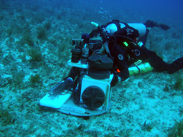
Installing oceanographic monitoring instrumentation on the seafloor
USGS research geologist Curt Storlazzi installs an instrument package on the seafloor of Maunalua Bay, Oʻahu. The platform, called a MiniPROBE, hosts six upward-looking acoustic Doppler current profilers (ADCP), seven conductivity and temperature (CT) sensors, and eight self-logging optical backscatter sensors (SLOBS).

Fish and coral in Tumon Bay Marine Reserve, Guam
Underwater photograph of Tumon Bay Marine Reserve, Guam, showing some of the amazing biologic diversity of coral reefs.
Underwater photograph of Tumon Bay Marine Reserve, Guam, showing some of the amazing biologic diversity of coral reefs.

Bleached coral in Tumon
Underwater photo of a stressed coral mound in Tumon Bay Marine Preserve in Guam.
Underwater photo of a stressed coral mound in Tumon Bay Marine Preserve in Guam.

Island-hopping Coral Larvae in Hawaii
Large-scale poster describing USGS work.
Large-scale poster describing USGS work.

Coral Larvae
Underwater photograph of larvae being released into the water column from reef-building coral spawning off Maui the night of June 30, 2003. The white larvae are about 0.5 to 1.5 mm across.
Underwater photograph of larvae being released into the water column from reef-building coral spawning off Maui the night of June 30, 2003. The white larvae are about 0.5 to 1.5 mm across.
Science and Products
- Science
Filter Total Items: 26
Quantifying Flood Risk and Reef Risk Reduction Benefits in Florida and Puerto Rico: The Consequences of Hurricane Damage, Long-term Degradation, and Restoration Opportunities
Coastal flooding and erosion from extreme weather events affect thousands of vulnerable coastal communities; the impacts of coastal flooding are predicted to worsen during this century because of population growth and climate change. Hurricanes Irma and Maria in 2017 were particularly devasting to humans and natural communities. The coral reefs off the State of Florida and the Commonwealth of...The Value of U.S. Coral Reefs for Risk Reduction
Summary of the report, “Rigorously valuing the role of U.S. coral reefs in coastal hazard risk reduction”
Coral Reef Project: Kauaʻi
As part of the USGS Coral Reef Project, the USGS is working on the island of Kauaʻi to identify circulation patterns and a sediment budget for Hanalei Bay to help determine any effects to the coastal marine ecosystem.Coral Reef Project: Puerto Rico
To better understand how waves move across coral reefs and cause flooding on tropical shorelines, USGS scientists have installed video cameras and oceanographic instruments off San Juan and Rincón, Puerto Rico. Their work is part of a study funded by USGS after Hurricanes Irma and María. The offshore instruments measure wave heights and speeds; the onshore video cameras show where waves break on...Coral Reef Project: Oʻahu
As part of the Coral Reef Project, the USGS is working closely with other local groups to investigate poor water quality issues in Maunalua Bay on the southeast coast of Oʻahu.Coral Reef Project: Guam
As part of the USGS Coral Reef Project, the USGS is working on the west coast of Guam to help determine the effects of sedimentation in nearshore waters.Coral Reef Project: Hawaiʻi
As part of the USGS Coral Reef Project, the USGS is working on the Kona (west) coast of Hawaiʻi to evaluate geologic resources at two historical parks.Coral Reef Project: Kahoʻolawe
As part of the USGS Coral Reef Project, the USGS is trying to better understand how nearshore processes impact the deeper, scattered coral reef communities of Kahoʻolawe.Coral Reef Project: Lānaʻi
Little is actually known about the overall extent, biodiversity, morphology, or health of Lānaʻi’s reef tracks. As part of the USGS Coral Reef Project, the USGS collected high-resolution swath bathymetry data and underwater video and photography in early 2013 in order to develop high-resolution seafloor habitat and reef morphology maps of the coral reef systems off of eastern Lānaʻi.Coral Reef Project: Tutuila
As part of the USGS Coral Reef Project, the USGS is working on Tutuila with its partners: 1.) in Faga’alu Bay to better understand the impacts of land-based pollutants on the coral reefs, and 2.) on the north coast to help determine the effects of circulation on nearshore waters.A Prioritization Plan for Coastal Wetland Restoration on Moloka‘i
Moloka‘i has great wetland restoration potential in Hawaiʻi, but most remaining sites are highly degraded. The future of several endangered waterbirds and insects relies on restoring coastal wetland habitat that is resilient under sea-level rise and coastal flooding. Currently, managers lack background data on Molokaʻi to prioritize sites for restoration. In this project, Researchers will developThe Impact of Sea-Level Rise on Coral Reef and Mangrove Interactions and the Resulting Coastal Flooding Hazards
Ecosystems such as coral reefs and mangroves provide an effective first line of defense against coastal hazards and represent a promising nature-based solution to adapt to sea-level rise. In many areas, coral reefs cause waves to break and lose energy, allowing for sediment to accumulate on the inshore portion of reef flats (i.e. the shallowest, flattest part of a reef) and mangroves to establish. - Data
- Maps
- Multimedia
Filter Total Items: 26
Installing oceanographic monitoring instrumentation on the seafloor
USGS research geologist Curt Storlazzi installs an instrument package on the seafloor of Maunalua Bay, Oʻahu. The platform, called a MiniPROBE, hosts six upward-looking acoustic Doppler current profilers (ADCP), seven conductivity and temperature (CT) sensors, and eight self-logging optical backscatter sensors (SLOBS).
USGS research geologist Curt Storlazzi installs an instrument package on the seafloor of Maunalua Bay, Oʻahu. The platform, called a MiniPROBE, hosts six upward-looking acoustic Doppler current profilers (ADCP), seven conductivity and temperature (CT) sensors, and eight self-logging optical backscatter sensors (SLOBS).
Fish and coral in Tumon Bay Marine Reserve, GuamUnderwater photograph of Tumon Bay Marine Reserve, Guam, showing some of the amazing biologic diversity of coral reefs.
Underwater photograph of Tumon Bay Marine Reserve, Guam, showing some of the amazing biologic diversity of coral reefs.
Bleached coral in TumonUnderwater photo of a stressed coral mound in Tumon Bay Marine Preserve in Guam.
Underwater photo of a stressed coral mound in Tumon Bay Marine Preserve in Guam.
Island-hopping Coral Larvae in HawaiiLarge-scale poster describing USGS work.
Large-scale poster describing USGS work.
Coral LarvaeUnderwater photograph of larvae being released into the water column from reef-building coral spawning off Maui the night of June 30, 2003. The white larvae are about 0.5 to 1.5 mm across.
Underwater photograph of larvae being released into the water column from reef-building coral spawning off Maui the night of June 30, 2003. The white larvae are about 0.5 to 1.5 mm across.
- Publications
- News