


USGS researchers running slope-area measurement in Ward Draw following storm of August 5, 2014. A group of thunderstorms produced greater than 4 inches of rain during four periods of progressively more intense rainfall across a small part of a relatively high-elevation area of the northern Black Hills on August 5, 2014.
Galen Hoogestraat
Galen Hoogestraat is a hydrologist for the Dakota Water Science Center (DWSC). Galen has been involved in various hydrologic investigations in the Dakotas including water-quality monitoring, stormwater, surface water models, and streamflow trends. Galen also serves as the DWSC reports specialist, social media coordinator, and is the current chair of the Western South Dakota Hydrology Conference.
Science and Products
Western South Dakota Hydrology Conference
The 2023 Western South Dakota Hydrology Conference will be held on April 20, 2023, at the Monument, Rapid City, SD. Registration will open on February 13, 2023. Previous years' program and abstracts are available from the "Multimedia" tab on this page.
Real-time, Continuous Nitrate Monitoring of the Big Sioux River near Sioux Falls, South Dakota
Project Period: ongoing Cooperators: City of Sioux Falls and East Dakota Water Development District Project Chief: Galen Hoogestraat
Study to Examine Water-Quality Concerns within Mount Rushmore National Memorial
Project Period: 2011-2016 Cooperators: Mount Rushmore National Memorial Project Chief: Galen Hoogestraat
Water-Quality Monitoring of Canyon Lake
Project Period: May 2017 - September 2018 Cooperator: West Dakota Water Development District Project Chief: Galen Hoogestraat
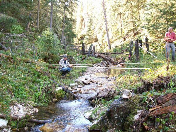
Slope-Area Measurements in Northern Black Hills, SD
USGS researchers running slope-area measurement in Ward Draw following storm of August 5, 2014. A group of thunderstorms produced greater than 4 inches of rain during four periods of progressively more intense rainfall across a small part of a relatively high-elevation area of the northern Black Hills on August 5, 2014.

Stormwater Runoff in Rapid City, SD
Looking downstream at the 3rd Street wetland channel following an August 2014 runoff event in Rapid City, SD. Runoff from this wetland channel discharges into Rapid Creek.
Looking downstream at the 3rd Street wetland channel following an August 2014 runoff event in Rapid City, SD. Runoff from this wetland channel discharges into Rapid Creek.

Stormwater Runoff in Rapid City, SD
Automated sampler bottles containing stormwater runoff from the Arrowhead drainage basin in Rapid City, SD, being processed in the laboratory. Stormwater runoff from urbanized lands is known to harm surface-water resources by increasing stream velocities, destroying natural habitat, and increasing pollutant loads in the receiving waters.
Automated sampler bottles containing stormwater runoff from the Arrowhead drainage basin in Rapid City, SD, being processed in the laboratory. Stormwater runoff from urbanized lands is known to harm surface-water resources by increasing stream velocities, destroying natural habitat, and increasing pollutant loads in the receiving waters.

Buffalo at Indirect Measurement at Beaver Creek, SD
U.S. Geological Survey Hydrologic Technician, Joel Petersen, has a buffalo audience while performing an indirect streamflow measurement survey at Beaver Creek near Pringle on August, 15, 2013.
U.S. Geological Survey Hydrologic Technician, Joel Petersen, has a buffalo audience while performing an indirect streamflow measurement survey at Beaver Creek near Pringle on August, 15, 2013.

Stormwater Runoff in Rapid City, SD
Stormwater runoff monitoring site at Meadowbrook Golf course, near the outlet of the Arrowhead drainage basin in Rapid City, SD.
Stormwater runoff monitoring site at Meadowbrook Golf course, near the outlet of the Arrowhead drainage basin in Rapid City, SD.
Science and Products
- Publications
- Science
Western South Dakota Hydrology Conference
The 2023 Western South Dakota Hydrology Conference will be held on April 20, 2023, at the Monument, Rapid City, SD. Registration will open on February 13, 2023. Previous years' program and abstracts are available from the "Multimedia" tab on this page.Real-time, Continuous Nitrate Monitoring of the Big Sioux River near Sioux Falls, South Dakota
Project Period: ongoing Cooperators: City of Sioux Falls and East Dakota Water Development District Project Chief: Galen HoogestraatStudy to Examine Water-Quality Concerns within Mount Rushmore National Memorial
Project Period: 2011-2016 Cooperators: Mount Rushmore National Memorial Project Chief: Galen HoogestraatWater-Quality Monitoring of Canyon Lake
Project Period: May 2017 - September 2018 Cooperator: West Dakota Water Development District Project Chief: Galen Hoogestraat - Data
- News
- Multimedia
Slope-Area Measurements in Northern Black Hills, SD
USGS researchers running slope-area measurement in Ward Draw following storm of August 5, 2014. A group of thunderstorms produced greater than 4 inches of rain during four periods of progressively more intense rainfall across a small part of a relatively high-elevation area of the northern Black Hills on August 5, 2014.
USGS researchers running slope-area measurement in Ward Draw following storm of August 5, 2014. A group of thunderstorms produced greater than 4 inches of rain during four periods of progressively more intense rainfall across a small part of a relatively high-elevation area of the northern Black Hills on August 5, 2014.
Stormwater Runoff in Rapid City, SDLooking downstream at the 3rd Street wetland channel following an August 2014 runoff event in Rapid City, SD. Runoff from this wetland channel discharges into Rapid Creek.
Looking downstream at the 3rd Street wetland channel following an August 2014 runoff event in Rapid City, SD. Runoff from this wetland channel discharges into Rapid Creek.
Stormwater Runoff in Rapid City, SDAutomated sampler bottles containing stormwater runoff from the Arrowhead drainage basin in Rapid City, SD, being processed in the laboratory. Stormwater runoff from urbanized lands is known to harm surface-water resources by increasing stream velocities, destroying natural habitat, and increasing pollutant loads in the receiving waters.
Automated sampler bottles containing stormwater runoff from the Arrowhead drainage basin in Rapid City, SD, being processed in the laboratory. Stormwater runoff from urbanized lands is known to harm surface-water resources by increasing stream velocities, destroying natural habitat, and increasing pollutant loads in the receiving waters.
Buffalo at Indirect Measurement at Beaver Creek, SDU.S. Geological Survey Hydrologic Technician, Joel Petersen, has a buffalo audience while performing an indirect streamflow measurement survey at Beaver Creek near Pringle on August, 15, 2013.
U.S. Geological Survey Hydrologic Technician, Joel Petersen, has a buffalo audience while performing an indirect streamflow measurement survey at Beaver Creek near Pringle on August, 15, 2013.
Stormwater Runoff in Rapid City, SDStormwater runoff monitoring site at Meadowbrook Golf course, near the outlet of the Arrowhead drainage basin in Rapid City, SD.
Stormwater runoff monitoring site at Meadowbrook Golf course, near the outlet of the Arrowhead drainage basin in Rapid City, SD.